Magellanstrædet
Magellanstrædet, stræde mellem Sydamerika og Ildlandet, opkaldt efter Ferdinand Magellan, der i 1520 sejlede gennem det.
Hele strædet ligger (siden 1843) i chilensk territorium.
| Wikimedia Commons har medier relateret til: |
Koordinater: 53°28′S 70°47′V / 53.467°S 70.783°V
|
Medier brugt på denne side
Forfatter/Opretter: Createaccount, Licens: CC BY-SA 3.0
Strait of Magellan, Chile
Straits of Magellan (June 21, 2004) - The Nimitz-class aircraft carrier USS Ronald Reagan (CVN 76) cruises through the Straits of Magellan on her way to the Pacific Ocean. Reagan is underway circumnavigating South America in transit to her new homeport of San Diego, Calif., while participating in exercises supporting Summer Pulse 2004. Summer Pulse 2004 is the simultaneous deployment of seven aircraft strike groups (CSGs), demonstrating the ability of the Navy to provide credible combat across the globe, in five theaters with other U.S., allied, and coalition military forces. Summer Pulse is the Navy’s first deployment under its new Fleet Response Plan (FRP). U.S. Navy photo by Photographer's Mate 3rd Class Elizabeth Thompson (RELEASED)For more information go to: <a href="http://www.cffc.navy.mil/summerpulse04.htm" Target="_BLANK">www.cffc.navy.mil/summerpulse04.htm</a>
Forfatter/Opretter: Miguel Vieira, Licens: CC BY 2.0
Commerson's dolphins (Cephalorhynchus commersonii) in the Strait of Magellan
Until the Panama Canal was finished in 1914, the Strait of Magellan was the only safe way to move between the Atlantic and Pacific Oceans. Protected by the Tierra del Fuego to the south and the bulk of South America to the north, ships crossed in relative ease, removed from the dangers of Drake Passage. Drake Passage is the relatively narrow stretch of ocean separating South America from Antarctica, the waters of which are notoriously turbulent, unpredictable, and frequented by icebergs and sea ice. In this unusually clear true-color Moderate Resolution Imaging Spectroradiometer (MODIS) image, the entire Strait is visible. The eastern opening is the wide bay on the border of Chile and Argentina. To the west, there are a number of access points from the Pacific, though the most easily seen here is the roughly 200 km stretch from the Queen Adelaide Archipelago (at center left) to the bulk of the Strait (at lower center). The islands and mountains are highlighted by bright white snow, while the lower-elevation lands to the north and east remain clear. This image was acquired by the Aqua satellite on August 27, 2003.
Forfatter/Opretter: Magallanes1, Licens: CC0
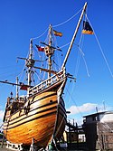
Replica de la Nao Victoria de Hernando de Magallanes en la ciudad de Punta Arenas


