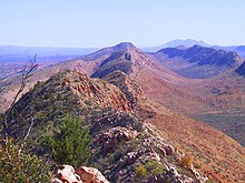
MacDonnell Ranges
23°42′S 132°30′Ø / 23.700°S 132.500°Ø

MacDonnell Ranges er en 644 km lang bjergkæde i det centrale Australien. Den består af parallelle bjergrygge, og løber øst og vest for Alice Springs.
| Spire |
Medier brugt på denne side
Forfatter/Opretter: Wikipedysty:Marcin n Dyskusja Wikipedysty:Marcin n, Licens: CC BY-SA 3.0
Australia stub (map outline of Australia containing flag of Australia)
View along the West MacDonnell Ranges from Counts Point on the Larapinta Trail. Mount Sonder, one of the higherst mountains in the Northern Territory, is in the background.

