Maastricht
| Maastricht Mestreech | |||||
|---|---|---|---|---|---|
| |||||
 Topografisk kommunekort december 2015 | |||||
 Maastricht kommunes beliggenhed i Nederlandene | |||||
| Overblik | |||||
| Land: | Nederlandene | ||||
| provins: | Limburg | ||||
| Postnr.: | 6200-6229 | ||||
| Demografi | |||||
| Kommune: | 120.2[1] (1. april 2016) | ||||
| - Areal: | 60,03 km² | ||||
| - Befolkningstæthed: | 2155 pr. km² | ||||
| Tidszone: | UTC +1 | ||||
| Højde m.o.h.: | 49 m | ||||
| Hjemmeside: | www.maastricht.nl | ||||
| Information med symbolet | |||||

Maastricht (![]() udtale ?; Limburgsk: Mestreech /məsˈtʁeːç/; fransk: Meuse) er en kommune og en by, beliggende i den sydlige provins Limburg i Nederlandene. Kommunens areal er på 60,03 km², og indbyggertallet er på 122.418 pr. 1. april 2016.[1]
udtale ?; Limburgsk: Mestreech /məsˈtʁeːç/; fransk: Meuse) er en kommune og en by, beliggende i den sydlige provins Limburg i Nederlandene. Kommunens areal er på 60,03 km², og indbyggertallet er på 122.418 pr. 1. april 2016.[1]

Byen ligger nordøst for grænsen til Belgien og vest for grænsen til Tyskland, og der er togforbindelser til Belgien, Heerlen og Eindhoven.
%2c_collectie_Centre_C%c3%a9ramique%2c_Maastricht.jpg)
Historie
Byen ligger ved bredderne af floden Maas. Den blev grundlagt af romerne ved et vadested,[2] (Latinsk: Traiectum Mosae, Traiectum ad Mosam, Mosa-trajectum) Også navnet Utrecht stammer fra det latinske Traiectum eller Triecht. Derfor blev navnet af floden tilføjet.[3] I 1051 blev for første gang navnet Masetrieth nedskrevet som senere blev bøjet til Maastricht.[4]
I 300-tallet etablerede den kristne biskop Skt. Servatius (død i 384, nederlandsk: Sint Servaas) et bispedømme i Maastricht. Den ældste bro over Maas er opkaldt efter ham, Skt. Servatiusbroen (nederlandsk: Sint Servaasbrug). Ligeledes den ældste kirke, Skt. Servatiuskirken (nederlandsk: Sint Servaaskerk).
I 1992 blev Maastricht-traktaten underskrevet her, hvilket skabte den Europæiske Union.
Kernerne
Maastricht består af fem bydele og mere end 40 landsbyer og bebyggelser.
- Maastricht Centrum (Binnenstad, Jekerkwartier, Kommelkwartier, Statenkwartier, Boschstraatkwartier, Sint Maartenspoort, Wyck-Céramique)
- Sydvest: (Villapark, Jekerdal, Biesland, Campagne, Wolder, Sint Pieter)
- Nordvest: (Brusselsepoort, Mariaberg, Belfort, Pottenberg, Malpertuis, Caberg, Malberg, Dousberg-Hazendans, Daalhof, Boschpoort, Bosscherveld, Frontenkwartier, Belvédère, Lanakerveld)
- Nordøst: (Beatrixhaven, Borgharen, Itteren, Meerssenhoven, Wyckerpoort, Wittevrouwenveld, Nazareth, Limmel, Amby)
- Sydøst: (Randwyck, Heugem, Heugemerveld, Scharn, Heer, De Heeg, Vroendaal)
Landsbyerne Itteren, Borgharen, Limmel, Amby, Heer, Heugem, Scharn, Oud-Caberg, Sint Pieter og Wolder har været selvstændige kommuner eller landsbyer men blev i løbet af 1900-tallet indlemmet i Maastricht Kommune.
Nabolandsbyer
- Neerharen (B*)
- Bunde
- Meerssen
- Berg en Terblijt
- Bemelen
- Cadier en Keer
- Gronsveld
- Oost
- Ternaaien (B)
- Kanne (B)
- Vroenhoven (B)
- Kesselt (B)
- Veldwezelt (B)
- Lanaken (B)
- ("(B)" = Belgien)
Kendte fra Maastricht

- Lambert af Maastricht (c. 636 – c. 705) – biskop, sankt
- Henrietta d'Oultremont (1792–1864) – 2. kone af Vilhelm 1. af Nederlandene
- André Rieu (født 1949) – violinist, conductor og musikskriver
- Maxime Verhagen (født 1956) – politiker
- Frans Timmermans (født 1961) – politiker
- Pieter van den Hoogenband (født 1978) – swømmer og tredobbelt Olympisk Mester
- Tom Dumoulin (født 1990) – cyklist
Hymne
I 2002 adopterede Maastricht Kommune den lokale hymne (Limburgsk: 'Mestreechs Volksleed', nederlandsk: Maastrichts Volkslied) med tekst skrevet på Maastrichtsk dialekt. Musikken var skrevet i 1910 af Ciprian Porumbescu (1853–1883).[5]
Maastrichtsk Kommunes folkesang (Mestreechs Volksleed) (adopteret i 2002, skrevet i 1910) |
|---|
|
Galleri
 Maastricht på en gravure af Simon de Bellomonte, 1500-tallet
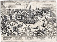 1579. Spanske soldater indtager byen
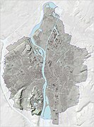 Reliefb af Maastricht Kommune
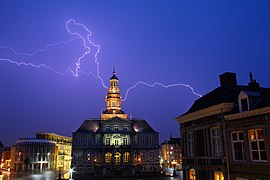
 Rommerske opgravninger i Museumkelder Derlon
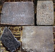 Sint-Servaasbasilieks Gravtombe
- Merovingisk gravhøj Vrijthof, 1970
 St-Servaasbasiliek
 St-Servaasbasiliek
 Onze Lieve Vrouwewal
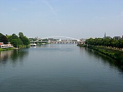
 Sint Servaasbrug
 Tinghus
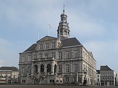 Rådhuset
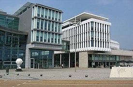 Mosae Forum
 Onze-Lieve-Vrouweplein
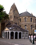 Onze-Lieve-Vrouwebasiliek
 Lang Grachtje
 Helpoort
 Pater Vinktoren
 Bastion Haet ende Nijt (Had og Misundelse)
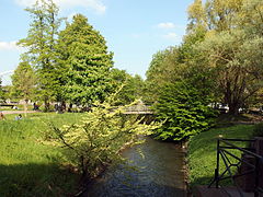 Bypark
 Bypark
 Jekerflode
 Havnebasin
 Sint-Lambertuskirke
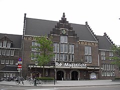 Maastrichts Hovedbanegård
 (c) T Houdijk, CC BY-SA 3.0Wyck, togstation
 Wyck, Stationstorv
 Hoeg Brögk, Céramique
 Charles Eyckpark
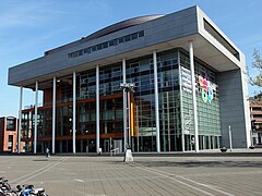 Biblioteket
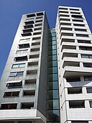 tårn: Siza's Toren
 Sint Pieterfort
 udsigt fra Slavante
 Lichtenberg Slotsruin
 Huis de Torentjes
 ENCI quarry
 Château Neercanne
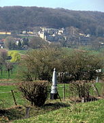 udsigt på Cannerberg
 Provinsens regeringsbygninger
 Kiste af Sint-Servaas i St-Servaasbasiliek
 Boghandler i en 1300-tallets kirke i Maastricht
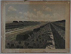 Tavle med billede af tørveskæring ses i udstillingsbygningen i bydelen Wyck-Céramique

Eksterne henvisninger
 Der findes også en Wikipedia på limburgsk.
- Kommunens hjemmeside (nederlandsk/hollandsk)
- Turistbureaets hjemmeside (engelsk)
- ^ a b CBS, Statline
- ^ Et vadested i Mase
- ^ Nicoline van der Sijs (2001), Chronologisch woordenboek. De ouderdom en herkomst van onze woorden en betekenissen, blz. 100, Uitgeverij L.J. Veen, Amsterdam/Antwerpen, ISBN 90-204-2045-3
- ^ M. Gysseling (1960), Toponymisch Woordenboek van België, Nederland, Luxemburg, Noord-Frankrijk en West-Duitsland (vóór 1226), blz. 646-647, George Michiels N.V., Tongeren
- ^ Municipality of Maastricht (2008). "Municipality of Maastricht: Maastrichts Volkslied". N.A. Maastricht. Arkiveret fra originalen 30. september 2011. Hentet 2009-08-05.
Medier brugt på denne side


A 1×1 transparent image. Useful for when a template requires an image but you don't have one.

Forfatter/Opretter: Mark Ahsmann, Licens: CC BY-SA 3.0
2013-05-04 in Maastricht; Céramique; Charles Eyckpark

Apsis van Onze Lieve Vrouwekerk in Maastricht

Forfatter/Opretter: Kleon3, Licens: CC BY-SA 4.0
View from the southwest of the the 12th-century Westwork of the Basilica of Saint Servatius in Maastricht, the Netherlands.

Forfatter/Opretter: Kleon3, Licens: CC BY-SA 3.0
Maastricht, the Netherlands. Panoramic view from mount Sint-Pietersberg towards the valley of the Jeker and the Cannerbos in the West. In the front a border marker: The photo is taken from the Dutch side towards the Belgian side.
%2c_collectie_Centre_C%c3%a9ramique%2c_Maastricht.jpg)
Educational wall picture formerly used in primary schools in the Netherlands. Here: "Peat bog in Drenthe", published in 1915 by J B Wolters in Groningen. Collection Centre Céramique, Maastricht, the Netherlands.

Province: Limburg is a part of the Netherlands
Forfatter/Opretter: Quichot, Licens: CC BY-SA 3.0
Quichot Little ogg: pronounciation of Dutch city

Forfatter/Opretter: The Sundowners (talk), Licens: CC BY-SA 3.0
The early 18th-century Fort Sint Pieter - Fortress Saint Peter - in Maastricht. A thorough restoration finished in 2008.

Forfatter/Opretter: Kleon3, Licens: CC BY-SA 3.0
Maastricht, the Netherlands. View of 'Siza's Tower', designed by Álvaro Siza. one of the buildings on Avenue Céramique, the main avenue in the newly developped Céramique district.

Forfatter/Opretter: The Sundowners (talk), Licens: CC BY-SA 3.0
The Lange Grachtje street in Maastricht, with a remaining section of the solid first city wall.

Forfatter/Opretter: Sb2s3, Licens: CC BY-SA 4.0
13th century Dominican church converted into a bookstore in Maastricht, the Netherlands

Forfatter/Opretter: The Sundowners (talk) (Transferred by Grondemar/Originally uploaded by The Sundowners), Licens: CC BY-SA 3.0
The famous Saint Servatius Basilica at the Vrijthof square in Maastricht.
Localização de Maastricht

Reliquary chest of Saint Servatius in the Treasury of the Basilica of Saint Servatius, Maastricht, Netherlands. So-called 'Christ panel' and 'Saint Peter side' of the chest. From left to right on the Saint Peter panel: St Peter, St Andrew, St Matthew, St Thomas, St Judas (Thaddeus) and St Simeon. Mosan (Maastricht?), gilded copper over wood.

Coat of arms of the Dutch municipality of Maastricht, Limburg.

Forfatter/Opretter: Janwillemvanaalst, Licens: CC BY-SA 4.0
Reliëfbeeld van de gemeente, o.b.v. het Actuele Hoogtebestand Nederland (AHN2, open data) met subtiele elementen uit de Basisregistratie Topografie (BRT/Top10NL, open data). Kaartbeeld samengesteld door Jan-Willem van Aalst.

Forfatter/Opretter: Otter, Licens: CC BY-SA 3.0
National monument 527161 - Museum Derlon, Plankstraat 21, Maastricht, The Netherlands

Maastricht, the Netherlands, the Market Suare. Spanish troops raiding the city in 1576.

Forfatter/Opretter: The Sundowners (talk) (Transferred by Grondemar/Originally uploaded by The Sundowners), Licens: CC BY-SA 3.0
The Meuse River cuts right through Maastricht, as seen here from the John F. Kennedy Bridge. The Hoge Brug - High Bridge - and Sint Servaasbrug - Saint Servatius Bridge - can be seen further up the river.

Forfatter/Opretter: henkiedenkie, Licens: CC BY-SA 3.0
Station Maastricht - 2009


Forfatter/Opretter: The Sundowners (talk), Licens: CC BY-SA 3.0
A view of the Mosae Forum shopping centre, located between Wilhelmina Bridge and the Market Square. Aside from various stores and shops, it also houses offices of city council. The much-praised design is one of renowned Dutch architect Jo Coenen

Forfatter/Opretter: Kleon3, Licens: CC BY-SA 3.0
Maastricht, the Netherlands. View of an artificial lake in the ENCI quarry on the hill Sint-Pietersberg, South of Maastricht. Landscape refurbishment is underway in this area as part of the closure of the quarry in 2018.

Forfatter/Opretter: Pierre Vossen, Licens: CC BY-SA 3.0
Lichtenberg Castle, overview

Forfatter/Opretter: Hans Peter Schaefer, http://www.reserv-a-rt.de, Licens: CC BY-SA 3.0
Maastricht, Platz vor der Liebfrauenkirche

Forfatter/Opretter: Julian Ilcheff Borissoff, Licens: CC BY 3.0
Provincial Government Buildings on the Meuse are depicted above, where the Maastricht Treaty (formally, the Treaty on European Union, TEU) was signed on 7 February 1992.
Educational wall picture formerly used in primary schools in the Netherlands. Here: "Camels in the desert", published around 1900. Collection Centre Céramique, Maastricht, the Netherlands.

Forfatter/Opretter: Kleon3, Licens: CC BY-SA 3.0
Maastricht, the Netherlands. View of Stationsplein with the Colonel office tower.
Maquette of Maastricht 1750

Forfatter/Opretter: The Sundowners (talk) (Transferred by Grondemar/Originally uploaded by The Sundowners), Licens: CC BY-SA 3.0
The 13th-century medieval Helpoort - Hells Gate - in Maastricht is one of the most impressive remaining fortifications of the city.

Forfatter/Opretter: Arne Hückelheim, Licens: CC BY-SA 3.0
Panorama of Vrijthof at Maastricht, Netherlands
Picture taken on an early sunday morning in June at 6:34 am
The square was absolutely empty, however one could still hear techno music from some club.
Forfatter/Opretter: Michielverbeek, Licens: CC BY-SA 3.0
Maastricht, church St. Lambertus (1916) by Hubert van Groenendael

Forfatter/Opretter: Mark Ahsmann, Licens: CC BY-SA 3.0
2013-05-05 in Maastricht. Céramique; Centre Céramique.
.jpg)
Forfatter/Opretter: Kleon3, Licens: CC BY-SA 4.0
Collage of four early Christian grave stones from the 5th and 6th century in the lapidarium ("stone collection") in the East Crypt of the Basilica of Saint Servatius in Maastricht, the Netherlands.

Forfatter/Opretter: Mark Ahsmann, Licens: CC BY-SA 3.0
2013-05-04 in Maastricht; Slavante. Walls of Slavante.

Forfatter/Opretter: Otter, Licens: CC BY-SA 3.0
National monument no. 28017 - Haat en Nijd, Maastricht, The Netherlands

Forfatter/Opretter: The Sundowners (talk) (Transferred by Grondemar/Originally uploaded by The Sundowners), Licens: CC BY-SA 3.0
The 2003-built Hoge Brug - High Bridge - is the most recent bridge of Maastricht. It is accessible only to pedestrians and bicyclists. The oldest bridge of Maastricht, and in fact of the Netherlands, can be seen in the background: the Sint Servaasbrug - Saint Servatius Bridge - dates back to the late 13th century.

Forfatter/Opretter: Eva van Mossevelde, Licens: CC BY 2.5
The 'Dinghuis' in Maastricht, The Netherlands. The building has been used for political and juridical purposes, and later used to be a theater. Currently, the bottom floor contains the Tourist Information Office. The name is derived from the Dutch word 'geding', which means 'lawsuit' and stems from the original use as a courtroom. So not to be confused with the Dutch word 'ding', which means 'thing', a common misconception.

(c) Rijksdienst voor het Cultureel Erfgoed, CC BY-SA 4.0
noord-zijde, naar het noorden, Merovingisch grafveld

Forfatter/Opretter: Otter, Licens: CC BY-SA 3.0
National monument no. 27963 - Huis De Torentjes, Lage Kanaaldijk 63, Maastricht, The Netherlands
Forfatter/Opretter: Karl-Heinz Meurer (--Charlie1965nrw), Licens: CC BY-SA 3.0
Andre Rieu bei seinem Kölner Konzert am 02.01.2010

Forfatter/Opretter: Arne Hückelheim, Licens: CC BY-SA 3.0
Panoramic view of Maastricht, Netherlands. Taken from St. Servatius Bridge spanning Maas River at 6:25 am on a sunday morning in June. Of course, the streets were actually empty - only my bike is leaned on the wall

Forfatter/Opretter: Kleon3, Licens: CC BY-SA 4.0
View of Onze Lieve Vrouwewal, part of the Medieval city wall of Maastricht, the Netherlands.

Forfatter/Opretter: The Sundowners (talk) (Transferred by Grondemar/Originally uploaded by The Sundowners), Licens: CC BY-SA 3.0
A picturesque corner of the public park in Maastricht.

Forfatter/Opretter: Michielverbeek, Licens: CC BY-SA 3.0
Maastricht, the town hall

drawing of Maastricht, by Philippo Bellomonte from 1580 or 1582

Forfatter/Opretter: The Sundowners (talk) (Transferred by Grondemar/Originally uploaded by The Sundowners), Licens: CC BY-SA 3.0
The Pater Vink Toren - Father Vink Tower - in Maastricht. The tower is named after a priest who was accused of treason during the Eighty Years' War.

Forfatter/Opretter: Pieter Hoogland, Licens: CC BY-SA 3.0 nl
Lightning above the city hall from Maastricht.

Forfatter/Opretter: Mark Ahsmann, Licens: CC BY-SA 3.0
2013-05-04 Maastricht City Park; Jeker.
Forfatter/Opretter: Janwillemvanaalst, Licens: CC BY-SA 4.0
Topografische gemeentekaart. Resolutie: 400 pixels/km.
Kaartbeeld samengesteld uit de open geodata van de Top10NL en Top25namen (Kadaster), Creative Commons-BY licentie. Gebouwvlakken uit open geodata BAG extract. Wegen uit de OpenStreetMap, OpenStreetMap community. Reliëfschaduw uit de Actuele Hoogtekaart AHN2.
Samenstelling en kleurenschema: Jan-Willem van Aalst, met QGIS. Zie ook de Legenda.

Bassin, Inner harbour in Maastricht, the Netherlands

Forfatter/Opretter: The Sundowners (talk), Licens: CC BY-SA 3.0
The small Jeker River passes through Maastricht.