Latakia
| Latakia اللاذقية | ||||||||
|---|---|---|---|---|---|---|---|---|
| ||||||||
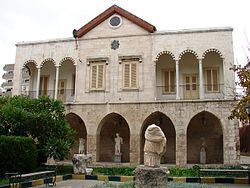
Collage af billeder fra Latakia | ||||||||
| Overblik | ||||||||
| Land | ||||||||
| Telefonkode | 041 | |||||||
| UN/LOCODE | SYLTK | |||||||
| Demografi | ||||||||
| Indbyggere | 700.000 (2009) | |||||||
| - Areal | 58,0 km² | |||||||
| - Befolkningstæthed | 12.069 pr. km² | |||||||
| Andet | ||||||||
| Højde m.o.h. | 0 m | |||||||
| Hjemmeside | www.elatakia.sy | |||||||
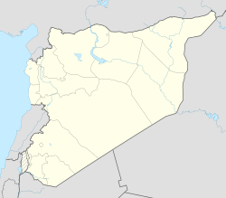
| Oversigtskort | ||||||||
(c) Karte: NordNordWest, Lizenz: Creative Commons by-sa-3.0 de Latakia | ||||||||
(på museet)
Latakia er en by på Syriens kyst ud til Middelhavet. Den er hovedby i et guvernement med samme navn og er sammen med den sydligere beliggende by Tartus en af Syriens vigtige havnebyer.[1]
Via Latakia eksporteres blandt andet landbrugsprodukter og der importeres færdigvarer. Byen har Syriens tredjestørste universitet "Tishrin" grundlagt i 1971. Området har flere ruiner fra romersk og hellenistisk tid.[1]
|
Tobak
Byen eller området har også lagt navn til en særlig type mørk tobak, 'Latakia-tobak'[2][3]
|
|
Se også
Referencer
- ^ a b Latakia i Store norske leksikon af Marcus Irgens, markeret med "fri gjenbruk. Creative Commons"
- ^ "Tobakstyper" hos Piberyger.dk, afsnittet 'Latakia' : "... Tobakkens særlige aroma er resultatet af en efterbehandling, der efter høst og tørring omfatter opvarmning/røgning af tobakken i særlige røglader, hvor der antændes bål af eg og fyrretræ tilsat aromatiske urter. ..."
- ^ Latakia i Den Store Danske på Lex.dk af Kirstine Sinclair og "Mellemøst-Information"
Eksterne henvisninger
- Latakia i Store norske leksikon af Marcus Irgens, markeret med "fri gjenbruk. Creative Commons" (norsk)
- Latakia i Den Store Danske på Lex.dk af Kirstine Sinclair og "Mellemøst-Information"
- Latakia hos Wikivoyage.org (engelsk)
- Lattakia, Syria Metro Area Population 1950-2024 Chart and table of population level and growth rate for the Lattakia, Syria metro area from 1950 to 2024. United Nations population projections are also included through the year 2035. (engelsk)
- Tidslinje for Latakia (engelsk)
- "History of Latakia, from Ugarit to the Assads (engelsk)
| Spire |
Medier brugt på denne side
Flag of Syria (2024-present) and the Syria Revolution
Wellenlinie als Gewässersymbol für die Formatvorlage Autobahn
A 1×1 transparent image. Useful for when a template requires an image but you don't have one.
Shiny black button/marker widget.
a map symbol for a mountain, the center is in the middle of the base line - as opposed to Fire.svg
Shiny green button/marker widget.
(c) Karte: NordNordWest, Lizenz: Creative Commons by-sa-3.0 de
Location map of Syria. De facto situation.
Exhibit in the Portland Museum of Art - Portland, Maine, USA.
Forfatter/Opretter: Dosseman, Licens: CC BY-SA 4.0
Once thought to be a city gate, but in reality giving access to a temple compound to the north. It has a remarkable weapons frieze.
Globally-used UNESCO World Heritage logo
Forfatter/Opretter: Bertramz, Licens: CC BY 3.0
Latin Church, Latakia, Syria.
Seal of Latakia City, Syria. 1975.
(c) Gianfranco Gazzetti / GAR, CC BY-SA 4.0
Museum courtyard, late antique sarcophagus, Latakia in 2006
Latakia Sports City aerial view in 1991, Latakia, Syria.
Forfatter/Opretter: Michael Goodine , Licens: CC BY 2.0
Latakia downtown view
Forfatter/Opretter: Edgars2007, Licens: CC BY 2.0
Archaeological site icon
a simple (unofficial) dam symbol.
Forfatter/Opretter: Rawpixel, Licens: CC BY-SA 4.0
Port of Latachia from Views in the Ottoman Dominions, in Europe, in Asia, and some of the Mediterranean islands (1810) illustrated by Luigi Mayer (1755-1803).
Forfatter/Opretter: Mikenorton, Licens: CC BY-SA 3.0
Bull's eye graphic for use with earthquake location maps
Flag of Syria. Originally flag of the Syria Revolution (from 2011), de facto flag of Syria beginning December 2024, official beginning March 2025.
Latakia harbour.
Forfatter/Opretter:

Latakia Governorate on Syria Map with its Subdistricts.
(c) Karte: NordNordWest, Lizenz: Creative Commons by-sa-3.0 de
Location map of the Levant
Forfatter/Opretter: Dosseman, Licens: CC BY-SA 4.0
Remains of a peripteral temple (the type with a portico with columns surrounding the central cella).
Forfatter/Opretter: Jadd Haidar, Licens: CC BY-SA 4.0
The previous Mandatory-era barracks and current school of Jules Jammal in Latakia, Syria.
(c) Firas1977 at engelsk Wikipedia, CC BY-SA 3.0
Municipal Stadium in Latakia / Syria


