Landkreis Fürth

Fürth
VåbenBeliggenhed
Coat of arms of Fürth
Tyskland, beliggenhed af Fürth markeret
Administration
LandTyskland Tyskland
DelstatBayern
Admin. regionMittelfranken
Admin. byZirndorf
Lokal inddeling14 kommuner
Statistiske data
Areal307,60 km²
Indbyggere117.387  (31/12/2018)
 - Tæthed382 Indb./km²
Andre informationer
TidszoneCET/CEST (UTC+1/UTC+2)
Nummerplade
Webstedwww.landkreis-fuerth.de
Beliggenhed af Fürth
Weiden in der OberpfalzStraubingWürzburgSchwabachSchweinfurtRegensburgRosenheimNürnbergNürnbergPassauLandshutMemmingenKaufbeurenKempten (Allgäu)IngolstadtFürthHofErlangenCoburgBayreuthBambergAugsburgMünchenAschaffenburgAmbergAnsbachLandkreis WürzburgLandkreis Wunsiedel im FichtelgebirgeLandkreis Weißenburg-GunzenhausenLandkreis Weilheim-SchongauLandkreis UnterallgäuLandkreis TraunsteinLandkreis TirschenreuthLandkreis Straubing-BogenLandkreis StarnbergLandkreis SchweinfurtLandkreis SchwandorfLandkreis Rottal-InnLandkreis RothLandkreis RosenheimLandkreis Rhön-GrabfeldLandkreis RegensburgLandkreis Pfaffenhofen an der IlmLandkreis RegenLandkreis PassauLandkreis OstallgäuLandkreis OberallgäuLandkreis Nürnberger LandLandkreis Neu-UlmLandkreis Neustadt an der WaldnaabLandkreis Neustadt an der Aisch-Bad WindsheimLandkreis Neumarkt in der OberpfalzLandkreis Neuburg-SchrobenhausenLandkreis MünchenLandkreis Mühldorf am InnLandkreis MiltenbergLandkreis MiesbachLandkreis Main-SpessartLandkreis Lindau (Bodensee)Landkreis LichtenfelsLandkreis LandshutLandkreis Landsberg am LechLandkreis KulmbachLandkreis KronachLandkreis KitzingenLandkreis KelheimLandkreis HofLandkreis HaßbergeLandkreis GünzburgLandkreis Garmisch-PartenkirchenLandkreis FürthLandkreis FürstenfeldbruckLandkreis Freyung-GrafenauLandkreis FreisingLandkreis ForchheimLandkreis Erlangen-HöchstadtLandkreis ErdingLandkreis EichstättLandkreis EbersbergLandkreis Donau-RiesLandkreis Dingolfing-LandauLandkreis Dillingen an der DonauLandkreis DeggendorfLandkreis DachauLandkreis CoburgLandkreis ChamLandkreis Berchtesgadener LandLandkreis BayreuthLandkreis BambergLandkreis Bad Tölz-WolfratshausenLandkreis Bad KissingenLandkreis AugsburgLandkreis AschaffenburgLandkreis AnsbachLandkreis Amberg-SulzbachLandkreis AltöttingLandkreis Aichach-FriedbergBodenseeSchweizØstrigBaden-WürttembergHessenTjekkietSachsenThüringenBeliggenheden af Landkreis Fürth i Bayern (klikbart kort)
Om dette billede

Landkreis Fürth er en landkreis i Regierungsbezirk Mittelfranken i den tyske delstat Bayern.

Geografi

Der Landkreis Fürth ligger vest for storbyområdet Nürnberg, som også byerne Zirndorf, Stein og Oberasbach er en del af. Mod vest går landkreisen over i det mere landbrugsprægede vestlige Mittelfranken. Landkreis Fürth er arealmæssigt den mindste Landkreis i Bayern. En højslette gennemskæres af brede dale med floderne Bibert, Zenn og flere mindre floder. I den nordlige del af landkreisen giver forekomster af ler basis for en omfattende teglværksindustri.

Nabokreise

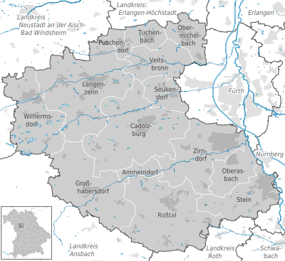
Nabokreise er mod nord Landkreis Erlangen-Höchstadt, mod øst de kreisfri byer Nürnberg og Fürth, mod syd Landkreis Roth, i sydvest Landkreis Ansbach og i nordvest Landkreis Neustadt an der Aisch-Bad Windsheim.

Byer og kommuner

Landkreis Fürth består af 14 kommuner, hvoraf de 4 har Stadsret.

Kreisen havde 117387 indbyggere pr. 2018-12-31 [1]

Landkreis FürthBayernLandkreis AnsbachLandkreis RothSchwabachErlangenLandkreis Neustadt an der Aisch-Bad WindsheimLandkreis Erlangen-HöchstadtFürthNürnbergObermichelbachTuchenbachPuschendorfVeitsbronnSeukendorfWilhermsdorfLangenzennCadolzburgGroßhabersdorfAmmerndorfRoßtalZirndorfOberasbachStein (Mittelfranken)
Imagemap med byer og kommuner

Byer

  1. Langenzenn (10665)
  2. Oberasbach (17672)
  3. Stein (13996)
  4. Zirndorf (25596)

Købstæder (markt)

  1. Ammerndorf (2058)
  2. Cadolzburg (11188)
  3. Roßtal (9868)
  4. Wilhermsdorf (5387)

Kommuner

  1. Großhabersdorf (4193)
  2. Obermichelbach (3321)
  3. Puschendorf (2330)
  4. Seukendorf (3128)
  5. Tuchenbach (1341)
  6. Veitsbronn (6644)

Verwaltungsgemeinschafte

  1. Obermichelbach-Tuchenbach
    med kommunerne Obermichelbach og Tuchenbach
  2. Veitsbronn
    med kommunerne Seukendorf og Veitsbronn

Eksterne henvisninger

Koordinater: 49°25′00″N 10°50′00″Ø / 49.416666666667°N 10.833333333333°Ø / 49.416666666667; 10.833333333333

Medier brugt på denne side

Bavaria FÜ (district).svg
Deutsch (de): Lagekarte von Landkreis Fürth in Bayern, Deutschland.
English (en): Locator map of District of Fürth in Bavaria, Germany.
français (fr): Plan de localisation de l'arrondissement Landkreis Fürth dans le Land Bayern, Allemagne.
Nederlands (nl): Detailkaart van Landkreis Fürth in Bayern, Duitsland.
Esperanto (eo): Situomapo de [[:eo:{{{mun}}}|komunumo nekonata]] en Landkreis Fürth, Bayern, Germanio.
മലയാളം (ml): ജർമ്മനിയിലെ Bavaria District of Fürth, ഭൂപടസ്ഥാനം.
Lage des Landkreises Fürth in Deutschland.png
Forfatter/Opretter: own work by Geograv, Licens: CC BY-SA 3.0
Landkreis Fürth, Bavaria, Germany
Municipalities in FÜ detailed.svg
Forfatter/Opretter: TUBS Gallery, Licens: CC BY-SA 2.0
Deutsch (de): Lagekarte von Landkreis Fürth in Bayern, Deutschland.
English (en): Locator map of District of Fürth in Bavaria, Germany.
français (fr): Plan de localisation de l'arrondissement de Ansbach dans le Land Bavière, Allemagne.
Nederlands (nl): Detailkaart van Landkreis Fürth in Bayern, Duitsland.
Esperanto (eo): Situomapo de komunumo nekonata en Landkreis Fürth, Bayern, Germanio.
മലയാളം (ml): ജർമ്മനിയിലെ Bavaria District of Fürth, ഭൂപടസ്ഥാനം.