Lancashire
| Lancashire | |
|---|---|
 | |
| Geografi | |
| Status | Ceremoniel & (mindre) Administrative County |
| Region | North West England |
| Areal - Samlet - Admin. grevskab - Admin. areal | 17. 3079 km² 16. 2903 km² |
| Admin.by | Preston |
| ISO 3166-2 | GB-CMA |
| ONS-kode | 30 |
| NUTS 3 | UKD43 |
| Demografi | |
| Indbyggere - Total (2016) - tæthed - Admin. grevskab - Admin. indb. | 8. 1.485.000 482/km² 4. 1.171.600 |
| Etnisk fordeling | |
| Politik | |
 Lancashire County Council http://www.lancashire.gov.uk | |
| Formand | Det Konservative Parti |
| Parlamentsmedlemmer | |
| Distrikter | |
 | |
Lancashire er et engelsk grevskab ved det Irske Hav.
Grevskabet grænser op til Cumbria, North Yorkshire, West Yorkshire, Greater Manchester, Merseyside og de selvstændige unitary authorities Blackpool og Blackburn med Darwen.
Lancashire er opdelt i lokaldistrikterne: Burnley, Chorley, Fylde, Hyndburn, Lancaster, Pendle, Preston, the Ribble Valley, Rossendale, South Ribble, West Lancashire og Wyre.
Lancashires befolkningstal blev i 2016 anslået til 1.485.000. Dets navn kommer af Lancaster + shire.
Grevskabet blev etableret i 1182. I den engelske jordebog fra Vilhelm Erobrerens tid, Domesday Book, blev det anset som en part af Cheshire og af Yorkshire. Dets grænser var Cumberland, Westmorland, Yorkshire og Cheshire.
Det moderne administrative område er i dag mindre end det var tidligere på grund af en selvstyrereform.
Den 1. april 1974 kom Furness-området i det nordlige Lancashire under det nye engelske grevskab Cumbria, den sydøstlige del til Greater Manchester, og det sydvestlige blev til Merseyside
Warrington og de omkringliggende distrikter med landsbyerne Winwick og Croft samt Risley og Culcheth blev indlemmet i Cheshire. En del af West Riding of Yorkshire ved Clitheroe blev ligeledes overført til Lancashire.
I 1998 blev Blackpool og Blackburn med Darwen selvstændige amter "unitary authorities", men forblev i Lancashire rent ceremonielt af historiske årsager, lige som brand, redningstjeneste og politi.
Bymæssige området i Lancashire
Bemærk: nogle af disse steder ligger ikke længere i Lancashire.
- Accrington, Adlington
- Bacup, Bamber Bridge, Barrow-in-Furness, Barnoldswick, Bickerstaffe, Blackburn, Blackpool, Bolton, Burnley, Burscough
- Carnforth, Chipping, Chorley, Clayton-le-Moors, Cleveleys, Clitheroe, Colne
- Dalton, Darwen
- Earby
- Fleetwood, Freckleton
- Galgate, Garstang, Gisburn, Goosnargh, Great Harwood
- Haslingden, Heysham, Hoghton
- Kirkham
- Lancaster, Lathom, Leyland, Liverpool, Longridge, Lytham
- Manchester, Mawdesley, Morecambe
- Nelson
- Ormskirk, Oswaldtwistle
- Padiham, Parbold, Pendle, Poulton-le-Fylde, Preston
- Rawtenstall, Ribchester, Rufford
- Silverdale, Skelmersdale, Slaidburn, St Annes
- Thornton, Trawden, Tyldesley
- Upholland
- Warrington, Whalley
Historie
Lancashire har givet navn til Hertugdømmet Lancaster, der har været i personalunion med England siden 1413.
Seværdigheder
- Arnside and Silverdale AONB

- Astley Hall

- Bank Hall
- Beacon Fell

- Blackburn Cathedral

- Blackpool Pleasure Beach

- Blackpool Tower
- Blackpool Zoo
- British Commercial Vehicle Museum, Leyland
- Camelot Theme Park
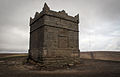
- Clitheroe Castle

- Darwen Tower
- East Lancashire Railway

- Forest of Bowland: Area of Outstanding Natural Beauty
- Gawthorpe Hall, Padiham

- Harris Museum

- Helmshore Mills Textile Museum
- Hoghton Tower
- Irwell Sculpture Trail
- Lancaster Castle
- Lancaster Cathedral
- Lathom Park Chapel, site of Lathom Hall, seat of the Earls of Derby
- Lytham Hall
- Leighton Moss nature reserve, Royal Society for the Protection of Birds
- Martin Mere, Wildfowl and Wetlands Trust nature reserve, Burscough
- Morecambe Bay
- Museum of Lancashire

- Pendle Hill
- The Pennines
- Ribble Steam Railway
- Rivington Pike
- Rufford Old Hall
- Samlesbury Hall
- St Walburge's Church
- Stonyhurst College – manor house dating from 1592, now a Jesuit public school
- Towneley Hall, Burnley
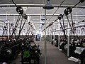
- Queen Street Mill, Burnley
- West Lancashire Light Railway
- West Pennine Moors
- Williamson Park and the Ashton Memorial
- Witton Country Park
- Yarrow Valley Park
- White Coppice
- Haigh Hall

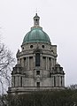
Ashton Memorial, Lancaster
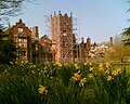
Bank Hall, Bretherton, jakobit-herregård. På grunden står Lancashires ældste takstræ og et af to fælede sequoiaer i Storbritannien

Blackpool Tower, færdiggjort i 1894
Rivington Pike, nær Horwich, på toppen af West Pennine Moors, er en af de mest populære vandredestinationer i landet. På klare dage kan hele countiet ses herfra.
 (c) Betty Longbottom, CC BY-SA 2.0
Queen Street Mill, verdens eneste tilbageværende damp-drevne bomuldsvæve-maskine. Ligger i Burnley
Eksterne henvisninger
Koordinater: 53°48′N 2°36′V / 53.8°N 2.6°V
|
Medier brugt på denne side


(c) Lupin fra en.wikipedia.org, CC BY-SA 3.0
Upper levels of the Ashton Memorial, exterior

Forfatter/Opretter: Parrot of Doom, Licens: CC BY-SA 4.0
Rivington Pike, with the Winter Hill mast in the background after 1990's restoration. Note 1733 date stone no longer present, foundations exposed by errosion.
Castle icon in SVG vector format
.jpg)
Forfatter/Opretter: Nathanemmison, Licens: CC BY-SA 4.0
This is a photo of listed building number 1205810.
Icon for use on UK lists of places of interest.

Forfatter/Opretter: Bankhall, Licens: CC BY-SA 3.0
Some of the Daffodils that grow at Bank Hall
Theme Park icon (UK)
.png)

A photograph of Clitheroe Castle taken on the 6th August 2007
Forfatter/Opretter: PNG Rastergrafik blev lavet med Inkscape. ., Licens: CC BY-SA 3.0
The Coat of arms of Lancashire County Council, the top-tier authority for the county of Lancashire, in North West England. The blazon is:
ARMS: Gules three Piles two issuant from the chief and one in base Or each charged with a Rose of the field barbed and seeded proper.
CREST: On a Wreath of the Colours a Lion passant guardant proper charged on the body with a Mascle Gules and resting the dexter forepaw on an Escocheon of the above said Arms.

(c) Betty Longbottom, CC BY-SA 2.0
Queen Street Mill - Weaving Shed
Historic House icon
For use with en:Template:EngPlacesKey or any other use.
Created by Naturenet