Kroatiens distrikter

Kroatiens distrikter
distrikt
Officielt navn: Hrvatske županije
LandKroatien Kroatien
HovedbyZagreb
Oprettet1992
[[Image:
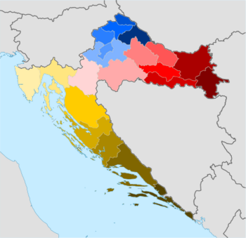
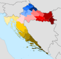
Map of present-day counties of CroatiaVukovar-Srijem distriktOsijek-Baranja distriktBrod-Posavina distriktPožega-Slavonia distriktVirovitica-Podravina distriktBjelovar-Bilogora distriktKoprivnica-Križevci distriktMeđimurje distriktVaraždin distriktKrapina-Zagorje distriktZagreb distriktZagrebSisak-Moslavina distriktKarlovac distriktIstria distriktPrimorje-Gorski Kotar distriktLika-Senj distriktZadar distriktŠibenik-Knin distriktSplit-Dalmatia distriktDubrovnik-Neretva distrikt
Distrikter i Kroatien:      Bjelovar-Bilogora      Brod-Posavina      Dubrovnik-Neretva      Istria      Karlovac      Koprivnica-Križevci      Krapina-Zagorje      Lika-Senj      Međimurje      Osijek-Baranja      Požega-Slavonia      Primorje-Gorski Kotar      Šibenik-Knin      Sisak-Moslavina      Split-Dalmatia      Varaždin      Virovitica-Podravina      Vukovar-Srijem      Zadar      Byen Zagreb      Zagreb distrikt
|256px|center| ]]

Kroatiens distrikter eller amter (kroatisk: hrvatske županije) er de administrative underinddelinger på første niveau i Republikken Kroatien.[1] Siden de blev genetableret i 1992, har Kroatien været opdelt i 20 distrikter og hovedstaden Zagreb, som har myndighed og juridisk status som både et amt og en by (adskilt fra det omkringliggende Zagreb distrikt).[2] Fra 2015 er amterne opdelt i 128 byer og 428 (for det meste landlige) kommuner.

Inddelingen har ændret sig over tid siden middelalderens kroatiske stat. De afspejlede territoriale tab og udvidelser; ændringer i den politiske status for Dalmatien, Dubrovnik og Istrien; og politiske omstændigheder, herunder personalunion og den efterfølgende udvikling af forholdet mellem Kongeriget Kroatien-Slavonien og Kongeriget Ungarn.[3]

Nuværende distrikter

Distrikter i Kroatien etableret i 1992
DistriktAdmin.Areal (2006)[4]Indb. (2021)[5]BNP per capita (2019)[6]VåbenKoordinater
Bjelovar-BilogoraBjelovar2.640 km²101.87907986€9.132Coat of arms of Bjelovar-Bilogora distrikt45°54′10″N 16°50′51″Ø / 45.90278°N 16.84750°Ø / 45.90278; 16.84750 (Bjelovar-Bilogora distrikt)
Brod-PosavinaSlavonski Brod2.030 km²130.26706607€8.211Coat of arms of Brod-Posavina County45°09′27″N 18°01′13″Ø / 45.15750°N 18.02028°Ø / 45.15750; 18.02028 (Brod-Posavina distrikt)
Dubrovnik-NeretvaDubrovnik1.781 km²115,56413277€14.673Coat of arms of Dubrovnik-Neretva County42°39′13″N 18°05′41″Ø / 42.65361°N 18.09472°Ø / 42.65361; 18.09472 (Dubrovnik-Neretva County)
IstriaPazin2.813 km²195.23715570€15.960Coat of arms of Istria County45°14′21″N 13°56′19″Ø / 45.23917°N 13.93861°Ø / 45.23917; 13.93861 (Istria County)
KarlovacKarlovac3.626 km²112,19508301€9,510Coat of arms of Karlovac County45°29′35″N 15°33′21″Ø / 45.49306°N 15.55583°Ø / 45.49306; 15.55583 (Karlovac County)
Koprivnica-KriževciKoprivnica1.748 km²101,22108711€10.110Coat of arms of Koprivnica-Križevci County46°10′12″N 16°54′33″Ø / 46.17000°N 16.90917°Ø / 46.17000; 16.90917 (Koprivnica-Križevci County)
Krapina-ZagorjeKrapina1.229 km²120,70207919€8.954Coat of arms of Krapina-Zagorje County46°7′30″N 15°48′25″Ø / 46.12500°N 15.80694°Ø / 46.12500; 15.80694 (Krapina-Zagorje County)
Lika-SenjGospić5.353 km²42,74808878€10.725Coat of arms of Lika-Senj County44°42′25″N 15°10′27″Ø / 44.70694°N 15.17417°Ø / 44.70694; 15.17417 (Lika-Senj County)
MeđimurjeCČakovecČakovec0,730729 km²105,25010302€11.476Coat of arms of Međimurje County46°27′58″N 16°24′50″Ø / 46.46611°N 16.41389°Ø / 46.46611; 16.41389 (Međimurje County)
Osijek-BaranjaOsijek4.155 km²258,02608684€10.232Coat of arms of Osijek-Baranja County45°38′13″N 18°37′5″Ø / 45.63694°N 18.61806°Ø / 45.63694; 18.61806 (Osijek-Baranja County)
Požega-SlavoniaPožega1.823 km²64,08406620€8.217Coat of arms of Požega-Slavonia County45°18′40″N 17°44′24″Ø / 45.31111°N 17.74000°Ø / 45.31111; 17.74000 (Požega-Slavonia County)
Primorje-Gorski KotarRijeka3.588 km²265,41914797€15.232Coat of arms of Primorje-Gorski Kotar County45°27′14″N 14°35′38″Ø / 45.45389°N 14.59389°Ø / 45.45389; 14.59389 (Primorje-Gorski Kotar County)
Sisak-MoslavinaSisak4.468 km²139,60307868€9,706Coat of arms of Sisak-Moslavina County45°13′15″N 16°15′5″Ø / 45.22083°N 16.25139°Ø / 45.22083; 16.25139 (Sisak-Moslavina County)
Split-DalmatiaSplit4.540 km²423,40709636€10.759Coat of arms of Split-Dalmatia County43°10′0″N 16°30′0″Ø / 43.16667°N 16.50000°Ø / 43.16667; 16.50000 (Split-Dalmatia County)
ŠibenikŠibenik-KninSŠibenikŠibenik2.984 km²96,38109713€11.325Coat of arms of Šibenik-Knin County43°55′44″N 16°3′43″Ø / 43.92889°N 16.06194°Ø / 43.92889; 16.06194 (Šibenik-Knin County)
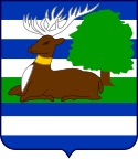
VaraždinVaraždin1.262 km²159,48710899€12.112Post-1992 coat of arms of Varaždin County46°19′16″N 16°13′52″Ø / 46.32111°N 16.23111°Ø / 46.32111; 16.23111 (Varaždin County)
Virovitica-PodravinaVirovitica2.024 km²70,36806525€7.869Coat of arms of Virovitica-Podravina County45°52′23″N 17°30′18″Ø / 45.87306°N 17.50500°Ø / 45.87306; 17.50500 (Virovitica-Podravina County)
Vukovar-SrijemVukovar2.454 km²143,11306730€8.606Coat of arms of Vukovar-Srijem County45°13′43″N 18°55′0″Ø / 45.22861°N 18.91667°Ø / 45.22861; 18.91667 (Vukovar-Srijem County)
ZadarZadar3.646 km²159,76610803€11.544Coat of arms of Zadar County44°1′5″N 15°53′42″Ø / 44.01806°N 15.89500°Ø / 44.01806; 15.89500 (Zadar County)
ZagrebZagreb3.060 km²299,98509710€10.769Post-1992 coat of arms of Zagreb County45°44′56″N 15°34′16″Ø / 45.74889°N 15.57111°Ø / 45.74889; 15.57111 (Zagreb County)
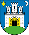
Zagreb byByen Zagreb0,641641 km²767,13122695 €23.742Coat of arms of the city of Zagreb45°49′0″N 15°59′0″Ø / 45.81667°N 15.98333°Ø / 45.81667; 15.98333 (City of Zagreb)

Referencer

  1. ^ "The Constitution of the Republic of Croatia (consolidated text)". Kroatiske Parlament. hentet 15. november 2022.
  2. ^ "Zakon o područjima županija, gradova i općina u Republici Hrvatskoj" Territories of Counties, Cities and Municipalities of the Republic of Croatia Act. Narodne novine (kroatisk). Republic of Croatia (10). 1997. ISSN 0027-7932.
  3. ^ Goldstein, Ivo (1996). Hrvatske županije kroz stoljeća [Croatian Counties Through the Centuries (kroatisk). Zagreb: Školska knjiga. ISBN 9789530613676.
  4. ^ "Županije – velike gospodarske razlike na malom prostoru" [Counties – Great Economic Differences in a Small Space (PDF)(kroatisk). Croatian Chamber of Economy. 2016. Retrieved 16. november 2022.
  5. ^ "Objavljeni konačni rezultati Popisa 2021" [Final Results of the 2021 Census Published (in Croatian). Croatian Bureau of Statistics. 22. september 2022. Retrieved 16. november 2022.
  6. ^ "Bruto domaći proizvod za Republiku Hrvatsku, HR NUTS 2 i županije u 2019" ([Gross domestic product for the Republic of Croatia, HR NUTS 2 and counties in 2019). Priopćenje Državnog zavoda za statistiku Republike Hrvatske (kroatisk). Croatian Bureau of Statistics. LIX (2022–2–1). ISSN 1334-0557.

Medier brugt på denne side

Flag of Croatia.svg
Det er let at give dette billede en kant
Zadar County coat of arms.png
Forfatter/Opretter: Timbouctou, Licens: CC BY-SA 3.0
Official coat of arms of the Zadar county in Croatia, made from gif version at http://www.crwflags.com/fotw/flags/hr-za.html#coa by Željko Heimer
Primorje-Gorski Kotar County coat of arms.png
Forfatter/Opretter: Timbouctou, Licens: CC BY-SA 3.0
Official coat of arms of the Primorje-Gorski Kotar county in Croatia, made from gif version at http://www.crwflags.com/fotw/flags/hr-ri.html#coa by Željko Heimer
Grb Istarske županije.svg
the coat of arms of the Istria County
Koprivnica County coat of arms.png
Forfatter/Opretter: Timbouctou, Licens: CC BY-SA 3.0
Official coat of arms of the Karlovac county in Croatia, made from gif version at http://www.crwflags.com/fotw/flags/hr-ka.html#coa by Željko Heimer
Dubrovnik-Neretva.svg
Coat of arms of Dubrovnik–Neretva County in Croatia
Požega-Slavonia County coat of arms.png
Forfatter/Opretter: Timbouctou, Licens: CC BY-SA 3.0
Official coat of arms of the Požega-Slavonia county in Croatia, made from gif version at http://www.crwflags.com/fotw/flags/hr-pz.html#coa by Željko Heimer
Coat of arms of Zagreb.svg
Coat of arms of Zagreb, Croatia
Coat of arms of Split-Dalmatia County.svg
Official coat of arms of the Split-Dalmatia county in Croatia. The coat of arms is Azure a Crown of Zvonimir Or. The crown of Zvonimir is based on the representation of the crown on the head of Croatian king found on the old Croatian engraving on a baptistery in early Romanic style of 11th century.
Croatia-counties-colorkey450px.png
Forfatter/Opretter: Tomobe03, Licens: CC BY-SA 3.0
450 px wide map of Croatian counties
Varaždin County coat of arms.png
Forfatter/Opretter: Timbouctou, Licens: CC BY-SA 3.0
Official coat of arms of the Varaždin county in Croatia, made from gif version at http://www.crwflags.com/fotw/flags/hr-vz.html#coa by Željko Heimer
Osijek-Baranja County Arms.png
Coat of arms of Osijek-Baranja County
Coat of arms of Šibenik County.svg
Coat of arms of Šibenik County
Bjelovar-Bilogora County coat of arms.png
Forfatter/Opretter: Timbouctou, Licens: CC BY-SA 3.0
Official coat of arms of the Bjelovar-Bilogora county in Croatia, made from gif version at http://www.crwflags.com/fotw/flags/hr-bj.html#coa by Željko Heimer
Coat of arms of Zagreb County.svg
Forfatter/Opretter: Eget arbejde, Licens: CC BY-SA 3.0
Official coat of arms of Zagreb county in Croatia, made from gif version at Coat of arms of Zagreb County by Željko Heimer
Sisak-Moslavina County coat of arms.png
Forfatter/Opretter: Timbouctou, Licens: CC BY-SA 3.0
Official coat of arms of the Sisak-Moslavina county in Croatia, made from gif version at http://www.crwflags.com/fotw/flags/hr-sk.html#coa by Željko Heimer
Virovitica-Podravina County coat of arms.png
Forfatter/Opretter: Timbouctou, Licens: CC BY-SA 3.0
Official coat of arms of the Virovitica-Podravina county in Croatia, made from gif version at http://www.crwflags.com/fotw/flags/hr-vi.html#coa by Željko Heimer