Kobe
| Kobe 神戸市 | |||||
|---|---|---|---|---|---|
| |||||
 | |||||
| Overblik | |||||
| Land | |||||
| Borgmester | Kizō Hisamoto | ||||
| Ø | Honshu | ||||
| Region | Kansai | ||||
| Præfektur | Hyōgo | ||||
| Grundlagt | 1. april 1889 | ||||
| Postnr. | 650-8570 | ||||
| UN/LOCODE | JPUKB | ||||
| Demografi | |||||
| Indbyggere | 1.513.193 (2021)[1] | ||||
| - Areal | 552 km² | ||||
| - Befolkningstæthed | 2.740 pr. km² | ||||
| Andet | |||||
| Tidszone | UTC+9 | ||||
| Hjemmeside | www.city.kobe.lg.jp | ||||
| Oversigtskort | |||||
 Kobe | |||||

Kobes havn
Kobe (神戸市 Kōbe-shi) er en by i Japan. Byen ligger på den vestlige del af øen Honshu ved Osakabugten. Den ligger ca. 30 kilometer vest for Osaka og er en af Japans vigtigste havnebyer. Den har 1.513.193(2021)[1] indbyggere og er hovedby i præfekturet Hyōgo.
Kobe blev i 1995 ramt af et jordskælv, der målte 7,2 på richterskalaen.
Michael Laudrup spillede en overgang for Kobes fodboldhold.
Galleri
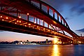
Kobe-ohashi 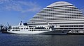
Luminous Kobe2 
Portopia Hotel 
Harbor land 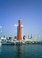
Kobes havn 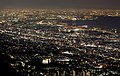
Night view 
Arima-Onsen
Referencer
- ^ a b 兵庫県/推計人口 兵庫県, hentet 31. marts 2021 (fra Wikidata).
Eksterne henvisninger
- KobeCityInfo(engelsk)
| Spire |
|
Medier brugt på denne side

Kobe Mosaic06s4s3200.jpg
Forfatter/Opretter: 663highland, Licens: CC BY 2.5
"MOSAIC" of Harborland in Kobe, Hyogo prefecture, Japan
Forfatter/Opretter: 663highland, Licens: CC BY 2.5
"MOSAIC" of Harborland in Kobe, Hyogo prefecture, Japan

Kobe-meriken-park-port-tower.jpg
Forfatter/Opretter: Tomomarusan, Licens: CC BY-SA 3.0
Kobe-meriken-park-port-tower
Forfatter/Opretter: Tomomarusan, Licens: CC BY-SA 3.0
Kobe-meriken-park-port-tower

Flag of Kobe.svg
Flag of Kobe, Hyogo
Flag of Kobe, Hyogo

Emblem of Kobe, Hyogo.svg
Emblem of Kobe, Hyogo
Emblem of Kobe, Hyogo

Flag-map of Japan.svg
Flag-map of Japan
Flag-map of Japan
Japan location map with side map of the Ryukyu Islands.svg
Forfatter/Opretter: Maximilian Dörrbecker (Chumwa), Licens: CC BY-SA 3.0
Location map of Japan
Forfatter/Opretter: Maximilian Dörrbecker (Chumwa), Licens: CC BY-SA 3.0
Location map of Japan
Equirectangular projection.
Geographic limits to locate objects in the main map with the main islands:
- N: 45°51'37" N (45.86°N)
- S: 30°01'13" N (30.02°N)
- W: 128°14'24" E (128.24°E)
- E: 149°16'13" E (149.27°E)
Geographic limits to locate objects in the side map with the Ryukyu Islands:
- N: 39°32'25" N (39.54°N)
- S: 23°42'36" N (23.71°N)
- W: 110°25'49" E (110.43°E)
- E: 131°26'25" E (131.44°E)

Portopia hotel02s3248.jpg
Forfatter/Opretter: 663highland, Licens: CC BY 2.5
"Portopia Hotel" in Kobe, Hyogo prefecture, Japan
Forfatter/Opretter: 663highland, Licens: CC BY 2.5
"Portopia Hotel" in Kobe, Hyogo prefecture, Japan

Kobe port island02s3200.jpg
Forfatter/Opretter: 663highland, Licens: CC BY 2.5
Kobe bridge (Kobe-ohashi) of the Kobe harbor at the time of twilight in Kobe, Hyogo prefecture, Japan
Forfatter/Opretter: 663highland, Licens: CC BY 2.5
Kobe bridge (Kobe-ohashi) of the Kobe harbor at the time of twilight in Kobe, Hyogo prefecture, Japan

Luminous kobe02s3200.jpg
Forfatter/Opretter: 663highland, Licens: CC BY 2.5
"Luminous Kobe2" at Port of Kobe in Kobe, Hyogo, Japan
Forfatter/Opretter: 663highland, Licens: CC BY 2.5
"Luminous Kobe2" at Port of Kobe in Kobe, Hyogo, Japan

Kobe takahama01s3200.jpg
Forfatter/Opretter: 663highland, Licens: CC BY 2.5
Harborland "Takahama-ganpeki" of the Kobe harbor ( Kobe, Hyogo prefecture, Japan)
Forfatter/Opretter: 663highland, Licens: CC BY 2.5
Harborland "Takahama-ganpeki" of the Kobe harbor ( Kobe, Hyogo prefecture, Japan)

Night view of Osaka bay.jpg
Forfatter/Opretter: Laitr Keiows, Licens: CC BY-SA 3.0
Night view of Osaka bay from Mount Maya
Forfatter/Opretter: Laitr Keiows, Licens: CC BY-SA 3.0
Night view of Osaka bay from Mount Maya
Port of Kobe02s4100.jpg
Forfatter/Opretter: 663highland, Licens: CC BY 2.5
Port of Kobe at twilight in Kobe, Hyōgo Prefecture, Japan
Forfatter/Opretter: 663highland, Licens: CC BY 2.5
Port of Kobe at twilight in Kobe, Hyōgo Prefecture, Japan

Kin-no-yu Arima Onsen03s3s.jpg
Forfatter/Opretter: 663highland, Licens: CC BY 2.5
Kin-no-yu in Arima onsen, Kobe, Hyogo prefecture, Japan
Forfatter/Opretter: 663highland, Licens: CC BY 2.5
Kin-no-yu in Arima onsen, Kobe, Hyogo prefecture, Japan