Jordskælvet i Christchurch 2011
 Kort over Christchurch | |
Epicenter for jordskælvet i Christchurch 2011 | |
| Dato | 22. februar 2011 |
|---|---|
| Dybde | 5 km |
| Epicenter | Nær Lyttelton i Canterbury |
| Lande og områder berørt | |
| Maks. intensitet | 6,3 MW[1] |
| Døde | 185 |
Jordskælvet i Christchurch 2011 var et jordskælv med momentmagnitude på 6,3,[1] som indtraf i Canterbury-regionen på Sydøen i New Zealand kl. 12.51 lokal tid den 22. februar 2011 (kl. 23.51 21. februar 2011 UTC).[1][2] Jordskælvets epicenter var 5 km under byen Lyttelton, og det medførte store ødelæggelser og flere dødsfald i nærliggende (10 km) Christchurch, New Zealands næststørste by med ca. 340.000 indbyggere.
Det var det største efterskælv efter jordskælvet i New Zealand 2010,[3] men anses også for at være et separat jordskælv. Det havde mindre magnitude end det tidligere, men forårsagede mere skade, fordi epicentret var nærmere Christchurch og var tættere på overfladen. Epicenteret ved jordskælvet i 2010 lå 33 km under jorden, mens dette kun var 5 km under jorden. Desuden skete dette jordskælv ved frokosttid på en tirsdag, hvor det forrige skete tidligt om morgenen på en lørdag, og mange bygninger var i forvejen skadede af de tidligere skælv.[4][5]
Jordskælvet forårsagede store materielle skader og kostede 185 mennesker livet.
Skader

I Christchurch og dens omgivelser blev mange bygninger ødelagt eller beskadiget. De stærkeste ødelæggelser havde de murede bygninger, men også jernbetonkonstruktioner, som Pyne Gould Guinness Building i bymidten blev totalt ødelagt. Byens vartegn Christ Church Cathedral fik store skader, kirketårnet styrtede ned og beskadigede dele af de øvrige bygninger. Der skete også store skader på historiske bygninger, som Canterbury Provincial Council Buildings og på den katolske Cathedral of the Blessed Sacrament.
Der skete også en del jordskred og i flere bydele forårsagede ødelagte vandrør oversvømmelser. På grund af revner og bygningsrester blev mange veje umulig at passere. Byens kommercielle fjernsynsstation, blev beskadiget og brændte derefter totalt ned. Der skete også andre steder i byen mange ildebrande.
Fra Tasman-Gletsjeren omkring 200 km fra skælvets epicenter faldt der få minutter efter jordskælvets udbrud et isstykke med en anslået masse på 30 millioner tons ned i søen for enden af gletsjeren og forårsagede en over 3 meter høj flodbølge.
På grund af ødelagte veje opstod der fordelingsproblemer på Sydøen og for at forhindre hamstring blev vigtige basisfødevarer fem dage efter jordskælvet frivilligt rationeret af supermarkedskæderne.
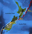
De større brudlinier i New Zealand med den relative bevægelse af den australske plade og Stillehavspladen

Sattelitfoto af Christchurch efter jordskælvet

Jordskælvskadet gade i bydelen North New Brighton

Christchurch 25. februar 2011
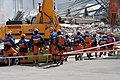
Japanske redningsfolk i Christchurch den 24. februar
Kilder
- ^ a b c GeoNet (2011-02-22). "New Zealand earthquake report - 22. februar 2011 kl. 12:51 pm (NZDT)" (engelsk). Arkiveret fra originalen 23. februar 2011. Hentet 2011-02-22.
- ^ USGS (2011-02-22). "M6.3 – South Island of New Zealand" (engelsk). Hentet 2011-02-22.
- ^ The New York Times (2011-02-22). "Scores Killed in New Zealand Earthquake" (engelsk). Hentet 2011-02-22.
{{cite web}}: Mere end en|forfatter=og|author=angivet (hjælp) - ^ NZ Herald (2011-02-22). "Deadly quake could be sign of more to come" (engelsk). Hentet 2011-02-22.
- ^ CBC News (2011-02-22). "New Zealand hit by strong quake, 65 dead" (engelsk). Hentet 2011-02-22.
Eksterne henvisninger
- Wikimedia Commons
- Uglesiden.dk (Webside ikke længere tilgængelig)
Koordinater: 43°36′S 172°43′Ø / 43.60°S 172.71°Ø
|
Medier brugt på denne side


Forfatter/Opretter: NordNordWest, Licens: CC BY-SA 3.0
Location map of New Zealand

Christchurch, New Zealand, February 25, 2011 -- Tim Manning, left, Deputy Administrator for Protection and National Preparedness at the Federal Emergency Management Agency, inspecting earthquake damage in Christchurch. Manning was in Christchurch attending a U.S.-N.Z. Partnership Forum when the earthquake struck. Manning, a first responder, immediately went to work with a local relief agency going door-to-door checking for structural integrity. FEMA/U.S. Embassy-New Zealand/Janine Burns
Forfatter/Opretter: Gabriel, Licens: CC BY 2.0
ChristChurch Cathedral showing the effects of the February 2011 earthquake.

Forfatter/Opretter: Gabriel, Licens: CC BY 2.0
Japanese urban search and rescue team in Christchurch, 24 February 2011.

Forfatter/Opretter: Mikenorton, Licens: CC BY-SA 3.0
Main fault zones associated with the plate boundary in New Zealand with displacement vectors relative to the Australian plate. Base map is a screenshot from the NASA World Wind software. Kermadec trench is located incorrectly. The Hikurangi subduction zone is off the east coast of the North Island, the Kermadec trench is located 1000km NE of New Zealand.

Satellite image of Christchurch and surrounding areas on 4 March 2011, about two weeks after the 2011 Christchurch earthquake. Circle colour indicates shaking strength, with deeper red meaning stronger shaking as shown in the key under the image.
NASA's caption: "It is a modern human tendency to focus on the number of an earthquake—specifically, the magnitude, or what people used to call the “Richter scale.” But the destruction from a quake usually has more to do with location and timing. Such was the case with the earthquake in Christchurch, New Zealand, on February 22, 2011.
"A September 2010 earthquake centered 40 kilometers (25 miles) west of Christchurch, in the plains near Darfield, struck at 4:35 a.m., had a magnitude of 7.1, and caused some structural damage and one death (by heart attack). The earthquake in February 2011 occurred at 12:51 p.m. and just 10 kilometers (6 miles) from the center of Christchurch. It had a magnitude of 6.3, though was officially classified—scientifically speaking—as an aftershock of the 2010 quake. At least 166 people died, and the city of Christchurch was devastated structurally and emotionally. Many people are still missing.
"The natural-color image above was captured on March 4, 2011, by the Advanced Land Imager (ALI) on NASA’s Earth Observing-1 (EO-1) satellite. Overlain on the map [not in this high resolution version] are seismological measurements of the ground shaking in the Christchurch area on February 22, as noted by the U.S. Geological Survey's Earthquake Hazard Program. "The deeper the red color of the circle, the more intense the “peak ground acceleration,” or shaking of the earth. Note how intensity is highest right around the most densely developed areas of Christchurch. City officials and news accounts also described liquefaction—the softening and loosening of the soil due to shaking and groundwater penetration—that was 300 to 500 percent worse than during the September 2010 earthquake.

Forfatter/Opretter: Mikenorton, Licens: CC BY-SA 3.0
Bull's eye graphic for use with earthquake location maps
Forfatter/Opretter: Benchill, Licens: CC BY-SA 2.0
Map of Christchurch, New Zealand, derivative of OpenStreetMap.

Forfatter/Opretter: Martin Luff, Licens: CC BY-SA 2.0
Car stuck in sink holes and liquefaction on roads - North New Brighton in Christchurch, New Zealand.