Jordandalen
Jordandalen (arabisk: arabisk: الغور Al-Ghor eller Al-Ghawr) er en forlænget fordybning af Riftdalen, lokaliseret i Israel og Jordan samt på Vestbredden og Golanhøjderne. Den geografiske region inkluderer Jordan-floden, Huladalen, Genesaretsøen og Dødehavet, det laveste landområde på Jorden.
Der bor i dag over 85.000 mennesker i området,[1] hvoraf de fleste lever af landbrug.
I henhold til Trumps fredsplan 2020 for Palæstina skal Jordandalen forenes med staten Israel.
Se også
Referencer
| Spire |
| Spire |
Koordinater: 32°19′02″N 35°34′12″Ø / 32.317222°N 35.57°Ø
|
Medier brugt på denne side
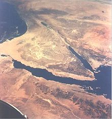
Near East area as seen from Gemini 11 spacecraft during its 26th revolution of the earth. The United Arab Republic (Egypt) is in foreground. Triangular-shaped area is the Sinai Peninsula. Saudi Arabia is at upper right. The Mediterranean Sea is at upper left. The Gulf of Suez separates Egypt from the Sinai Peninsula. The Red Sea is at bottom right. The Gulf of Aqaba is body of water in right center of photography separating the Sinai Peninsula and the Arabian Peninsula. The Dead Sea, Sea of Galilee, Jordan and Israel are in top center of picture. Iraq is at top right edge of photograph.
Mapo of Jordan with flag
Forfatter/Opretter: Aktron, Licens: CC BY-SA 3.0
Flag-map of Israel in 1949-1967 boundaries


