Jenin
| Jenin جنين | |
|---|---|
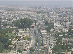
 Udsigt over Jenin, o. 2010 | |
| Overblik | |
| Land | Skabelon:Lande data Staten Palæstina |
| Andet | |
| Tidszone | UTC+2 (normaltid) UTC+3 (Palestine Summer Time[1]) |
| Oversigtskort | |
Jenin (arabisk: جنين; hebraisk: ג'נין) er en by i guvernementet Jenin[2] på Vestbredden. Guvernementet er et vigtigt landbrugsområde.[kilde mangler] Byen fik selvstyre i 1995 som en af de første på Vestbredden[3], og er af israelerne blevet beskyldt for at være et center for selvmordsbombere.[4]
|
Referencer
- ^ Navnet er anført på engelsk og stammer fra Wikidata hvor navnet endnu ikke findes på dansk.
- ^ 'Janin' hos Citypopulation.de (Governorate in Palestinian Territories)
- ^ "Jenin" i Den Store Danske hos Lex.dk
- ^ 'Jenin rises from the dirt' hos Bbc.co.uk, 24. juni 2003 ("... The action was in retribution for a Passover suicide bombing in Netanya, which claimed the lives of 28 Israelis in March last year. ..."
Eksterne henvisninger
 Wikimedia Commons har flere filer relaterede til Jenin – Jenin flygtningelejr
- "Jenin" i Den Store Danske hos Lex.dk
- "Jenin i Store Norske Leksikon hos Snl.no af Jørgen Jensehaugen ("PRIO Institutt for fredsforskning")
- 'Janin' hos Citypopulation.de (Governorate in Palestinian Territories)
- "Israel attacks Jenin in biggest West Bank incursion in 20 years" hos Theguardian.com, 3. juli 2023
| Spire Denne artikel om Palæstinas geografi er en spire som bør udbygges. Du er velkommen til at hjælpe Wikipedia ved at udvide den. |
Medier brugt på denne side
Letiště. Určený symbol č. 307 pro dopravní značky podle přílohy č. 7 vyhlášky č. 294/2015 Sb., kterou se provádějí pravidla provozu na pozemních komunikacích.
Shiny LightSteelBlue button/marker widget. Used to mark the location of something such as a tourist attraction.
Stub image for modern Palestine (West Bank and Gaza strip).
Forfatter/Opretter: Edgars2007, Licens: CC BY 2.0
Archaeological site icon
Forfatter/Opretter: Guillaume Paumier, Licens: CC BY 3.0
Streets of Jenin, West Bank
A 1×1 transparent image. Useful for when a template requires an image but you don't have one.
Shiny green button/marker widget.
Forfatter/Opretter: NordNordWest, Licens: CC BY-SA 3.0
Location map of Israel. De facto situation.
Forfatter/Opretter: Guillaume Paumier, Licens: CC BY 3.0
Streets of Jenin, West Bank
Forfatter/Opretter: Guillaume Paumier, Licens: CC BY 3.0
Streets of Jenin, West Bank
a map symbol for a mountain, the center is in the middle of the base line - as opposed to Fire.svg


