Interstate Highway 80 i Californien

I-80 starter ved et motorvejskryds med U.S. Highway 101 i San Francisco, og derefter krydser den San Francisco-Oakland Bay Bridge og kører ind i Oakland. Efter omkring 130 kilometer i nordøstlig retning kører I-80 ind i Sacramento, hvor den mødes med I-5. I-80 kører gennem Sierra Nevada-bjergene, og krydser efter omkring 320 kilometer i Californien ind i Nevada. På stykker er den kendt som San Fransisco Skyway, Eastshore Freeway og Roseville Freeway. Den går også under navnene Kent D. Pursel Memorial Freeway, Linus F. Claeys Freeway, Alan S. Hart Freeway og Dutch Flat and Donner Lake Wagon Road.
Fartgrænsen er intet sted mere end 65 miles i timen (ca. 105 km/t).[1]
I Sierra Nevada-bjergene falder der ofte sne i vinterhalvåret, og en gang i mellem er vinterkæder påkrævet. Det højeste punkt i bjergene ligger i 2.206 meters højde, og går under navnet Euer Saddle.
Tilslutninger
 | ||
|---|---|---|
| Interstate Highway 80 i Californien | ||
| Afkørsel | Afstand | Destination |
| 1 mile | ||
| 1 mile | Ninth Street | |
| 1 mile | Seventh Street | |
| 2 miles | Fifth Street | |
| 2 miles | Fourth Street | |
| 2 miles | Harrison Street | |
| 2 miles | Fremont Street; Folsom Street | |
| San Francisco-Oakland Bay Bridge (vestlige del) | ||
| 4 miles | Treasure Island | |
| 4 miles | Yearba Buena Island | |
| San Francisco-Oakland Bay Bridge (østlige del) | ||
| 8 miles | ||
| 8 miles | ||
| 9 miles | Powell Street (mod Emeryville) | |
| 10 miles | ||
| 11 miles | University Avenue (mod University of California, Berkeley) | |
| 12 miles | Gilman Street | |
| 13 miles | Buchanan Street (mod Albany) | |
| 13 miles | ||
| 14 miles | Central Avenue (mod El Cerrito) | |
| 14 miles | Carlson Boulevard | |
| 15 miles | Portrero Avenue; | |
| 16 miles | MacDonald Avenue | |
| 16 miles | San Pablo Avenue | |
| 17 miles | Solano Avenue; McBryde Avenue | |
| 18 miles | San Pablo Dam Road | |
| 19 miles | El Portal Drive | |
| 19 miles | Hilltop Mall | |
| 20 miles | Richmond Parkway (mod | |
| 21 miles | Appian Way | |
| 22 miles | Pinole Valley Road | |
| 23 miles | ||
| 24 miles | Willow Avenue | |
| 26 miles | Cummings Skyway (mod | |
| 27 miles | Pomona Street | |
| Carquinez Bridge | ||
| 29 miles | ||
| 29 miles | Sequoia Avenue | |
| 29 miles | Magazine Street | |
| 30 miles | ||
| 30 miles | Frontage Road | |
| 30 miles | Georgia Road | |
| 31 miles | Springs Road; Solano Avenue | |
| 31 miles | Tennessee Street | |
| 32 miles | Redwood Parkway | |
| 33 miles | ||
| 36 miles | American Canyon Road | |
| 39 miles | Red Top Road | |
| 39 miles | ||
| 40 miles | Green Valley Road; | |
| 41 miles | Suisun Valley Road | |
| 43 miles | ||
| 44 miles | Abernathy Road | |
| 44 miles | West Texas Street | |
| 45 miles | Travis Boulevard | |
| 47 miles | Waterman Boulevard | |
| 48 miles | North Texas Street | |
| 51 miles | Lagoon Valley Road | |
| 51 miles | Peña Adobe Road | |
| 52 miles | Cherry Glen Road | |
| 53 miles | Alamo Drive; Merchant Street | |
| 54 miles | Davis Street | |
| 54 miles | Peabody Road; Mason Street | |
| 55 miles | Monta Vista Avenue; Allison Drive; Nut Tree Parkway | |
| 56 miles | ||
| 57 miles | Leisure Town Road; Vaca Valley Parkway | |
| 59 miles | Meridian Road; Weber Road | |
| 60 miles | Midway Road; Lewis Road | |
| 63 miles | Dixon Avenue; West A Street (mod Dixon) | |
| 64 miles | Pitt School Road | |
| 66 miles | ||
| 66 miles | Milk Farm Road | |
| 67 miles | Pedrick Road | |
| 69 miles | Kidwell Road | |
| 70 miles | ||
| 71 miles | University of California, Davis | |
| 72 miles | Richards Boulevard (mod Downtown Davis) | |
| 73 miles | Olive Drive | |
| 75 miles | Mace Boulevard | |
| 78 miles | Road 32A; East Chiles Road | |
| Yolo Causeway | ||
| 81 miles | West Capitol Avenue; Enterprise Boulevard (mod West Sacramento) | |
| 82 miles | ||
| 83 miles | Reed Avenue (mod West Sacramento) | |
| 85 miles | West El Camino Avenue | |
| 86 miles | ||
| 88 miles | Truxel Road | |
| 89 miles | Northgate Boulevard | |
| 90 miles | Norwood Avenue | |
| 91 miles | Raley Boulevard; Marysville Boulevard (mod Del Paso Heights) | |
| 92 miles | Winters Street | |
| 93 miles | Longview Drive | |
| 94 miles | Watt Avenue | |
| 94 miles | Auburn Boulevard | |
| 95 miles | ||
| 96 miles | Madison Avenue | |
| 98 miles | Greenback Lane; Elkhorn Boulevard | |
| 100 miles | Antelope Road | |
| 102 miles | Riverside Avenue; Auburn Boulevard (mod Roseville og Citrus Heights) | |
| 103 miles | Douglas Boulevard; Sunrise Avenue | |
| 105 miles | Atlantic Street; Eureka Road | |
| 105 miles | Taylor Road; Pacific Street | |
| 106 miles | ||
| 108 miles | Rocklin Road | |
| 109 miles | Sierre College Boulevard | |
| 110 miles | Horseshoe Bar Road | |
| 112 miles | Penryn Road | |
| 115 miles | Newcastle Road | |
| 116 miles | ||
| 119 miles | Maple Street; Nevada Street | |
| 119 miles | ||
| 119 miles | Elm Avenue | |
| 120 miles | Lincoln Way, Russell Way | |
| 121 miles | Auburn Ravine Road | |
| 122 miles | Bowman | |
| 123 miles | Bell Road | |
| 124 miles | Dry Creek Road | |
| 125 miles | Clipper Gap; Meadow Vista | |
| 128 miles | Applegate | |
| 129 miles | Heather Glen | |
| 139 miles | West Paoli Lane | |
| 131 miles | Weimar Cross Road | |
| 133 miles | Canyon Way; Placer Hills Road | |
| 135 miles | ||
| 139 miles | Rollins Lake Road; Magra Road | |
| 140 miles | Secret Town Road; Magra Road | |
| 143 miles | Magra Road | |
| 144 miles | Gold Run | |
| 145 miles | Dutch Flat | |
| 146 miles | Alta | |
| 148 miles | Crystal Springs | |
| 148 miles | Baxter | |
| 150 miles | Drum Forebay Road | |
| 155 miles | Blue Canyon | |
| 156 miles | Nyack Road | |
| 158 miles | Emigrant Gap | |
| 158 miles | Laing Road | |
| 160 miles | Yuba Gap | |
| 161 miles | ||
| 165 miles | Cisco Road | |
| 166 miles | Big Bend | |
| 166 miles | Rainbow Road | |
| 171 miles | Kingvale | |
| 174 miles | Soda Springs og Norden | |
| 176 miles | Boreal Ridge Road | |
| 180 miles | Donner Lake Road | |
| 184 miles | Donner Pass Road | |
| 185 miles | ||
| 186 miles | Central Truckee | |
| 188 miles | Truckee | |
| 188 miles | ||
| 190 miles | Overland Trail | |
| 194 miles | Hirschdale Road | |
| 199 miles | Floriston | |
| 201 miles | Farad | |
| I-80 øst (mod Reno) - fortsætter ind i Nevada | ||
Galleri

Den vestlige ende af I-80

I-80 i Sierra Nevada-bjergene
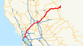
I-80 i Californien

Yolo Causeway
Referencer
- ^ "California Speed Limit". Arkiveret fra originalen 6. februar 2015. Hentet 24. november 2014.
Koordinater: 39°19′01″N 120°36′50″V / 39.317°N 120.614°V
Medier brugt på denne side


Vector image of a 24 in by 25 in (600 mm by 635 mm) California State Route shield. Colors are from [1] (Pantone Green 342), converted to RGB by [2]. The outside border has a width of 1 (1/16 in) and a color of black so it shows up; in reality, signs have no outside border.

Vector image of a 24 in by 25 in (600 mm by 635 mm) California State Route shield. Colors are from [1] (Pantone Green 342), converted to RGB by [2]. The outside border has a width of 1 (1/16 in) and a color of black so it shows up; in reality, signs have no outside border.

.svg)
28 in by 24 in (711 mm by 610 mm) California-style U.S. Route shield, made to the specifications of the 2002 edition of Standard Highway Signs with 10 in (250 mm) numerals. Uses the Roadgeek fonts. (United States law does not permit the copyrighting of typeface designs, and the fonts are meant to be copies of a U.S. Government-produced work anyway.)

Vector image of a 24 in by 25 in (600 mm by 635 mm) California State Route shield. Colors are from [1] (Pantone Green 342), converted to RGB by [2]. The outside border has a width of 1 (1/16 in) and a color of black so it shows up; in reality, signs have no outside border.
Forfatter/Opretter: User Minesweeper on en.wikipedia, Licens: CC BY-SA 3.0
Looking south above en:Interstate 80, the Eastshore Freeway, near en:Berkeley, California on a Saturday afternoon. en:Emeryville, California is at the towers, en:Aquatic Park (Berkeley) is visible to the left. To the right is the east shore of the en:San Francisco Bay. Picture taken by Minesweeper on May 14, 2005.

Forfatter/Opretter: Cullen328, Licens: CC BY-SA 3.0
The Yolo Causeway for Interstate 80 — seen from the entrance to the Yolo Bypass Wildlife Area in Yolo County.
- Photo by Jim Heaphy.

Vector image of a 24 in by 25 in (600 mm by 635 mm) California State Route shield. Colors are from [1] (Pantone Green 342), converted to RGB by [2]. The outside border has a width of 1 (1/16 in) and a color of black so it shows up; in reality, signs have no outside border.

Vector image of a 24 in by 25 in (600 mm by 635 mm) California State Route shield. Colors are from [1] (Pantone Green 342), converted to RGB by [2]. The outside border has a width of 1 (1/16 in) and a color of black so it shows up; in reality, signs have no outside border.

Motorway Junction Icon (blue).

Vector image of a 24 in by 25 in (600 mm by 635 mm) California State Route shield. Colors are from [1] (Pantone Green 342), converted to RGB by [2]. The outside border has a width of 1 (1/16 in) and a color of black so it shows up; in reality, signs have no outside border.

California State Route 89 shield.

Vector image of a 24 in by 25 in (600 mm by 635 mm) California State Route shield. Colors are from [1] (Pantone Green 342), converted to RGB by [2]. The outside border has a width of 1 (1/16 in) and a color of black so it shows up; in reality, signs have no outside border.

Vector image of a 24 in by 25 in (600 mm by 635 mm) California State Route shield. Colors are from [1] (Pantone Green 342), converted to RGB by [2]. The outside border has a width of 1 (1/16 in) and a color of black so it shows up; in reality, signs have no outside border.

Vector image of a 24 in by 25 in (600 mm by 635 mm) California State Route shield. Colors are from [1] (Pantone Green 342), converted to RGB by [2]. The outside border has a width of 1 (1/16 in) and a color of black so it shows up; in reality, signs have no outside border.


Vector image of a 24 in by 25 in (600 mm by 635 mm) California State Route shield. Colors are from [1] (Pantone Green 342), converted to RGB by [2]. The outside border has a width of 1 (1/16 in) and a color of black so it shows up; in reality, signs have no outside border.


Forfatter/Opretter: user:Coolcaesar, Licens: CC BY-SA 3.0
The interchange of Interstate 80 with U.S. Highway 101 in San Francisco. This is where Interstate 80 starts or ends, depending upon which way one is traveling.

Vector image of a 24 in by 25 in (600 mm by 635 mm) California State Route shield. Colors are from [1] (Pantone Green 342), converted to RGB by [2]. The outside border has a width of 1 (1/16 in) and a color of black so it shows up; in reality, signs have no outside border.


Vector image of a 24 in by 25 in (600 mm by 635 mm) California State Route shield. Colors are from [1] (Pantone Green 342), converted to RGB by [2]. The outside border has a width of 1 (1/16 in) and a color of black so it shows up; in reality, signs have no outside border.

Forfatter/Opretter: Davemeistermoab, Licens: CC BY-SA 4.0
Interstate 80 near the junction with California State Route 20 on the western approach to Donner Summit

.svg)


Vector image of a 24 in by 25 in (600 mm by 635 mm) California State Route shield. Colors are from [1] (Pantone Green 342), converted to RGB by [2]. The outside border has a width of 1 (1/16 in) and a color of black so it shows up; in reality, signs have no outside border.


600 mm by 600 mm (24 in by 24 in) Interstate shield, made to the specifications of the 2004 edition of Standard Highway Signs (sign M1-1). Uses the Roadgeek 2005 fonts. (United States law does not permit the copyrighting of typeface designs, and the fonts are meant to be copies of a U.S. Government-produced work anyway.) Colors are from [1] (Pantone Red 187 and Blue 294), converted to RGB by [2]. The outside border has a width of 1 (1 mm) and a color of black so it shows up; in reality, signs have no outside border.

Vector image of a 24 in by 25 in (600 mm by 635 mm) California State Route shield. Colors are from [1] (Pantone Green 342), converted to RGB by [2]. The outside border has a width of 1 (1/16 in) and a color of black so it shows up; in reality, signs have no outside border.

Map of Interstate 80 in California. The Interstate runs from the Bay Bridge in San Francisco, east through Sacramento and over the Sierra Nevada, to the Nevada border en route to Reno, Nevada.