Huntington (West Virginia)
| Huntington | |||||
|---|---|---|---|---|---|
| |||||
 | |||||
| Overblik | |||||
| Land | |||||
| Delstat | West Virginia | ||||
| County | Cabell | ||||
| Grundlagt | 1870 | ||||
| Telefonkode | 304 | ||||
| Demografi | |||||
| Indbyggere | 48.113 (2016)[1] | ||||
| Andet | |||||
| Tidszone | Eastern Time Zone | ||||
| Højde m.o.h. | 172 m | ||||
| Hjemmeside | www.cityofhuntington.com | ||||
| Oversigtskort | |||||
| West Virginias beliggenhed i USA | |||||
Huntington er en by i den amerikanske delstat West Virginia. Byen har 48.113(2016)[1] indbyggere og er administrativt centrum i det amerikanske county Cabell County.
Personer fra Huntington
- Thomas Massie (1971-), politiker i USAs kongress
- Justice M. Chambers
- Robert E. Femoyer
- Evan Jenkins, politiker i U.S. Congress
Referencer
- ^ a b www.census.gov (fra Wikidata).
Eksterne henvisninger
| Spire |
|
Medier brugt på denne side
(c) Lokal_Profil, CC BY-SA 2.5
Map showing Mainland USA ("lower 48") with a superimposed US flag.
Forfatter/Opretter: Wvfunnyman, Licens: CC BY-SA 3.0
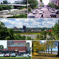
Clockwise: the Paul Ambrose Trail for Health (PATH), the Old Main Corridor, Downtown Huntington as seen from across the Ohio River, Harris Riverfront Park in the Fall, and the Huntington Welcome Center at Heritage Station.
Forfatter/Opretter: Wvfunnyman, Licens: CC BY-SA 3.0
Seal of the City of Huntington, WV
Forfatter/Opretter: Wvfunnyman, Licens: CC BY-SA 3.0
The city flag of Huntington, WV.
Forfatter/Opretter: This version: uploader
Base versions this one is derived from: originally created by en:User:Wapcaplet, Licens: CC BY 2.0
Map of USA with West Virginia highlighted
Forfatter/Opretter: Alexrk2, Licens: CC BY 3.0
Location map of West Virginia, USA
Equirectangular projection, N/S stretching 130.0 %. Geographic limits of the map:
- N: 40.8° N
- S: 37.0° N
- W: 82.8° W
- E: 77.5° W


