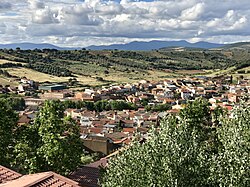
Horcajo de los Montes
| Horcajo de los Montes | |||
|---|---|---|---|
| |||
 | |||
| Overblik | |||
| Land | |||
| Autonom region | |||
| Provins | |||
| Amt | Montes | ||
| Borgmester | Alfredo Enrique Prado Fernández[1] | ||
| Postnr. | 13110 | ||
| Nummerpladebogstav(er) | CR | ||
| Demografi | |||
| Indbyggere | 795 (2024) | ||
| - Areal | 208 km² | ||
| - Befolkningstæthed | 3,81 pr. km² | ||
| Andet | |||
| Tidszone | UTC+1 | ||
| Højde m.o.h. | 780 m | ||
| Hjemmeside | aytohorcajodelosmontes.es | ||
| Oversigtskort | |||
| Kommunens beliggenhed i provinsen Ciudad Real | |||
(c) Miguillen, CC BY-SA 3.0 Horcajo de los Montes | |||
Horcajo de los Montes er en by og kommune i det sydlige centrale Spanien i provinsen Ciudad Real. Den har et indbyggertal på 795 (2024) indbyggere.
Se også
Referencer
Eksterne henvisninger
| Spire |
Medier brugt på denne side
Forfatter/Opretter: Roi González Villa (Vivaelcelta), Licens: CC BY-SA 3.0
Location map of Spain
Equirectangular projection, N/S stretching 130 %. Geographic limits of the map:
- N: 44.4° N
- S: 34.7° N
- W: 9.9° W
- E: 4.8° E
Forfatter/Opretter: jynus, Licens: CC BY-SA 3.0
Silhouette of Spain with Spanish Flag.
Forfatter/Opretter: Waltie, Licens: CC BY-SA 4.0
Overzichtsfoto Horcajo de los Montes vanaf hooggelegen camping. Gemaakt tijdens reis in 2018.
Forfatter/Opretter: Ulaidh, Licens: CC BY-SA 4.0
Bandera de la provincia de Ciudad Real (España)
Forfatter/Opretter: Tschubby, Licens: CC BY-SA 3.0
Gemeinde Horcajo de los Montes
SIn bordes.
(c) Miguillen, CC BY-SA 3.0
Location map of Castile-La Mancha


