Hill County (Texas)

 For alternative betydninger, se Hill County. (Se også artikler, som begynder med Hill County)
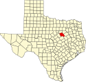
Hill County er et county i den amerikanske delstat Texas. Den ligger i de centrale dele af delstaten og det grænser mod Johnson County i nord, Ellis County i nordøst, Navarro County i øst, Limestone County i sydøst, McLennan County i syd og mod Bosque County i vest.
Hill Countys totale areal er 2.553 km² hvoraf 60 km² er vand. I år 2000 havde fylket 32.361 indbyggere og administrationscentret ligger i byen Hillsboro. Hill County er blevet opkaldt efter George Washington Hill.
Byer
- Abbott
- Aquilla
- Blum
- Bowman Community
- Bynum
- Carl's Corner
- Covington
- Hillsboro
- Hubbard
- Itasca
- Malone
- Mertens
- Mount Calm
- Penelope
- Whitney
Eksterne henvisninger
| ||||||||
| Spire |
Koordinater: 31°59′N 97°08′V / 31.99°N 97.13°V
|
Medier brugt på denne side
(c) Lokal_Profil, CC BY-SA 2.5
Map showing Mainland USA ("lower 48") with a superimposed US flag.
This is a locator map showing Hill County in Texas. For more information, see Commons:United States county locator maps.


