Haut-Uele
| Haut-Uele | |
|---|---|
 | |
| Overblik | |
| Land | |
| Provinshovedstad | Isiro |
| Demografi | |
| Indbyggere | 2.242.500 (2020)[1] |
| - Areal | 89.683 km² |
| - Befolkningstæthed | 25,0 pr. km² |
| Andet | |
| Hjemmeside | provinceduhautuele.cd |
| Koordinater | 2°46′35.02″N 27°37′4.48″Ø / 2.7763944°N 27.6179111°Ø |
| Oversigtskort | |
Haut-Uele er en provins i Den Demokratiske Republik Congo. Den er en af de 21 provinser, der blev oprettet ved opdelingen i 2015. Opdelingen af den tidligere provins Orientale førte til oprettelsen af provinserne Haut-Uélé, Bas-Uélé, Ituri og Tshopo.[2] Haut-Uélé blev dannet af Haut-Uélé-distriktet, hvis by Isiro blev hovedstad i den nye provins.
Administration
De vigtigste byer er Niangara, Dungu, Faradje, Watsa, Rungu, Isiro and Wamba.[3] Provinsen hovedstad er byen Isiro.[4]
Provinsen er inddelt i seks territorier:
Territories are
- Dungu
- Faradje
- Niangara
- Rungu
- Wamba
- Watsa
Referencer
- ^ www.citypopulation.de (fra Wikidata).
- ^ "Découpage territorial : procédures d'installation de nouvelles provinces". Radio Okapi (fransk). 13. juli 2015. Arkiveret fra originalen 19. juli 2015. Hentet 5. juni 2020.
- ^ Blaes, X. (oktober 2008). "Découpage administratif de la République Démocratique du Congo" (PDF). PNUD-SIG. Arkiveret fra originalen (PDF) 1. april 2010. Hentet 9. december 2011.
- ^ "Provinces of the Democratic Republic of Congo". Statiods.com. Arkiveret fra originalen 5. februar 2012. Hentet 24. januar 2012.
Medier brugt på denne side
The national flag of the Democratic Republic of the Congo. Created according to the 2006 constitution : Son emblème est le drapeau bleu ciel, orné d’une étoile jaune dans le coin supérieur gauche et traversé en biais d’une bande rouge finement encadrée de jaune. (Its symbol is a sky blue flag, decorated with a yellow star in the upper left corner and crossed in the diagonal by a red strip with thin yellow borders) It seems to be identical, except for a lighter field hue, to the 1966–1971 flag.
Forfatter/Opretter: Julien Harneis, Licens: CC BY-SA 2.0
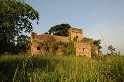
Dungu in the far north of the Democratic Republic of Congo borders on the Central African Republic and the south of Sudan. There are no government troops there since the local people asked them to leave two years ago. The infamous Lords Resistance Army is in the area, they crisscross the notional borders in the area attacking villages, kidnapping looting and killing. I was there to see what UNICEF needs to do to help. We stayed in sleepy Dungu meeting with local authorities and peace keepers.
In the early mornings I managed to make some time to visit. Dungu is pretty much cut off from the rest of the Congo, in the dry season it takes three to five weeks by truck from the nearest town, longer in the wet season. A small plane or two run by NGOs or missionaries come by in the week. The town itself is collection of huts under the mango trees strung out along a river. As in many such areas mud huts rub up against crumbling colonial brickwork interspersed with electricity pylons that have long since lost their cables.
I was not expecting the castle. A neo-medieval brick pile looming out of the mist over the river eaten up by the jungle. An old man collecting wood in the overgrown courtyard said that it had been the residence of the colonial Administrator and his first secretary. I waded through the dew wet grasses and went in, or rather I hesitated wondering what was in this hulk and then went in; It was a Walt Disney sleeping beautys castle, stripped bare, empty except for birds and bats.Forfatter/Opretter: Derivative work: User:Profoss - Original work:NordNordWest, Licens: CC BY-SA 3.0
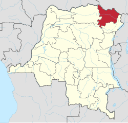
Location of Province (see file name) in Democratic Republic of the Congo
Forfatter/Opretter: Darwinek, Licens: CC BY-SA 3.0
Flag-map of the Democratic Republic of the Congo


