Haut-Katanga
| Haut-Katanga Haut-Katanga | |
|---|---|
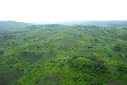
 Bakker i Katanga i regntiden | |
| Overblik | |
| Land | |
| Provinshovedstad | Lubumbashi |
| Guvernør | Jacques Kyabula[1] |
| Grundlagt | juli 2015 |
| Demografi | |
| Indbyggere | 5.718.800 (2020)[2] |
| - Areal | 132.425 km² |
| - Befolkningstæthed | 43,2 pr. km² |
| Andet | |
| Tidszone | UTC+2 |
| Koordinater | 11°40′S 27°29′Ø / 11.667°S 27.483°Ø |
| Oversigtskort | |
Haut-Katanga (Swahili: Jimbo la Lualaba) er en af de 26 Provinser i Demokratiske Republik Congo. Provinserne Tanganyika, Haut-Katanga, Haut-Lomami og Lualaba er resultatet af opdelingen af den tidligere provins Katanga.[3] Haut-Katanga blev dannet af distriktet Haut-Katanga og de uafhængige byer Likasi og Lubumbashi. Lubumbashi bibeholdt sin status som provinshovedstad, og i 2020, havde den en befolkning på, anslået 5.718.800 mennesker.[4]
Den nye provinss territorium svarer til det historiske Katanga-Oriental, der eksisterede i den tidlige periode efter Congos uafhængighed, mellem 1963 og 1966.
Sammen med Lualaba er Haut-Katanga en del af Kobberbæltet i Centralafrika. Kun Chile, Peru og Kina producerer mere kobber globalt end Congo.
Inddeling

Haut-Katanga er inddelt i 6 territorier og to byer:
- Kambove
- Kasenga
- Kipushi
- Mitwaba
- Pweto
- Sakania
- Byer
Referencer
- ^ Lukusa, Patient (11. juli 2024). "Haut-Katanga : Le gouvernement provincial investi". 7sur7.cd (fransk). Hentet 14. juli 2024.
- ^ www.citypopulation.de (fra Wikidata).
- ^ "Le Katanga officiellement démembré en quatre nouvelles provinces". Radio Okapi (fransk). 16. juli 2015. Arkiveret fra originalen 19. juli 2015. Hentet 8. juni 2020.
- ^ "Congo (Dem. Rep.): Provinces, Major Cities & Towns - Population Statistics, Maps, Charts, Weather and Web Information". www.citypopulation.de. Arkiveret fra originalen 26. juni 2022. Hentet 11. februar 2024.
Medier brugt på denne side
The national flag of the Democratic Republic of the Congo. Created according to the 2006 constitution : Son emblème est le drapeau bleu ciel, orné d’une étoile jaune dans le coin supérieur gauche et traversé en biais d’une bande rouge finement encadrée de jaune. (Its symbol is a sky blue flag, decorated with a yellow star in the upper left corner and crossed in the diagonal by a red strip with thin yellow borders) It seems to be identical, except for a lighter field hue, to the 1966–1971 flag.
Forfatter/Opretter: Darwinek, Licens: CC BY-SA 3.0
Flag-map of the Democratic Republic of the Congo
Forfatter/Opretter: GeoBall05, Licens: CC BY-SA 4.0
A map of Haut-Katanga presenting its Territories.
Forfatter/Opretter: Derivative work: User:Profoss - Original work:NordNordWest, Licens: CC BY-SA 3.0
Location of Province (see file name) in Democratic Republic of the Congo
Forfatter/Opretter: sebastienlavoie, Licens: CC BY-SA 3.0
Les collines verdoyantes du Katanga durant la saison des pluies.


