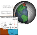
Generel cirkulationsmodel

En global klimamodel eller generel cirkulationsmodel (GCM, engelsk: Global Climate Model) er en model, der prøver at skildre hvordan klimaet ændrer sig ved at bruge ligninger fra væskedynamikken, kemien og blandt andet biologien. Disse ligninger er enten baseret på fysiske love, såsom Newtons love eller Termodynamikkens 2. lov, eller bliver konstrueret ud fra empiriske metoder. Der findes både atmosfæriske modeller (AGCM) og havmodeller (OCGM). En ACGM og en OCGM er ofte koblet sammen (AOGCM). Sammen med andre modeller (for f.eks. havis eller fordampning over land) danner AOGCM grundlaget for en fuld klimamodel. De forskellige modeller kan være opbygget på forskellig måde og indeholde forskellige komponenter, som kan give forskellige resultater, og er altid forbundet med en vis usikkerhed.[1] De første AOGCM blev bygget i slutningen af 1960'erne af Syokoru Manabe og Kirk Bryan ved Geophysical Fluid Dynamics Laboratory i Princeton i New Jersey.
I dag har man mellem ti og tyve institutioner på verdensplan som kører AOGCM'er for at varsle om klimaforandringer.
Henvisninger
| Spire Denne artikel om klima og klimaforandringer er en spire som bør udbygges. Du er velkommen til at hjælpe Wikipedia ved at udvide den. |
Medier brugt på denne side
Before the year 2004, only two tropical cyclones had ever been noted in the South Atlantic Basin, and no hurricane. However, a circulation center well off the coast of southern Brazil developed tropical cyclone characteristics and continued to intensify as it moved westward. The system developed an eye and apparently reached hurricane strength on Friday, March 26, before eventually making landfall late on Saturday, March 27, 2004.
The crew of the International Space Station was notified of the cyclone and acquired excellent photographs of the storm just as it made landfall on the southern Brazilian state of Santa Catarina (the storm has been unofficially dubbed “Cyclone Catarina”). Note the clockwise circulation of Southern Hemisphere cyclones, the well-defined banding features, and the eyewall of at least a Category 1 system. The coastline is visible under the clouds in the upper left corner of the image.
Climate models are systems of differential equations based on the basic laws of physics, fluid motion, and chemistry. To “run” a model, scientists divide the planet into a 3-dimensional grid, apply the basic equations, and evaluate the results. Atmospheric models calculate winds, heat transfer, radiation, relative humidity, and surface hydrology within each grid and evaluate interactions with neighboring points.

