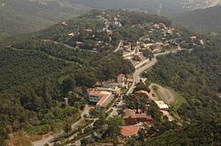
Gavà
| Gavanenc Gavà | |||||
|---|---|---|---|---|---|
| |||||
 | |||||
| Overblik | |||||
| Land | |||||
| Borgmester | Raquel Sánchez Jiménez | ||||
| Region | |||||
| Provins | Barcelona | ||||
| Comarca | Baix Llobregat | ||||
| Postnr. | 08850 | ||||
| Nummerpladebogstav(er) | B | ||||
| Demografi | |||||
| Indbyggere | 47.057 (2020) | ||||
| - Areal | 30,8 km² | ||||
| - Befolkningstæthed | 1.530 pr. km² | ||||
| Andet | |||||
| Tidszone | UTC+1 | ||||
| Højde m.o.h. | 9 m | ||||
| Hjemmeside | www.gavaciutat.cat | ||||
| Oversigtskort | |||||
| Cataloniens beliggenhed i Spanien | |||||
Gavà (Catalansk udtale: [ɡəˈβa]) er en catalansk by og kommune i comarcaet Baix Llobregat i provinsen Barcelona i det nordøstlige Spanien. Byen har 47.057(2020) indbyggere og dækker et areal på 30,90 km². Den er beliggende mellem byerne Castelldefels og Viladecans. Gavà betjenes af RENFE, der bl.a. opererer mellem Barcelona-Sants og dele af Spanien.
Demografi
| 1900 | 1930 | 1950 | 1970 | 1986 | 2002 | 2007 |
|---|---|---|---|---|---|---|
| 1.825 | 5.054 | 6.860 | 24.213 | 32.351 | 42.304 | 44.678 |
Referencer
Eksterne henvisninger
| ||||||||
|
Medier brugt på denne side
The senyera, a flag of Catalonia, and also used by several lands and municipalities of the ancient Crown of Aragon
Coat of Arms of Gavà, with Saint Peter's keys and the flag of Catalonia
Location map of Catalonia. Equirectangular projection, N/S stretching 130 %. Geographic limits of the map: * N: 42.99° N * S: 40.405° N * W: 0.55° O * E: 4.02° O
Forfatter/Opretter: TUBS
Location of region xy (see filename) in Spain.
Forfatter/Opretter: MrPotato1010, Licens: CC BY-SA 4.0
Bandera no oficial del municipi de Gavà (Baix Llobregat).


