Galičica

Galičica (makedonsk: Галичица (![]() hør), albansk: Mali i Thatë) er et bjerg beliggende på tværs af grænsen mellem Nordmakedonien og Albanien. Der er en nationalpark på Nordmakedoniens side af bjerget, beliggende mellem de to største søer i republikken: Ohridsøen og Prespasøen. Den har et areal på 227 km2
hør), albansk: Mali i Thatë) er et bjerg beliggende på tværs af grænsen mellem Nordmakedonien og Albanien. Der er en nationalpark på Nordmakedoniens side af bjerget, beliggende mellem de to største søer i republikken: Ohridsøen og Prespasøen. Den har et areal på 227 km2
Galičica er blandt de rigeste på endemiske arter blandt bjergene i Nordmakedonien.[1] Blomsterlivet i Galičica Nationalpark repræsenterer over 1600 arter, hvoraf mange har deres eneste udbredelsesområde præcis på bjerget Galičica.
Udsigten over søerne og de tilstødende bjerge kan ses fra Galičica-toppene. Den højeste top er Magaro, der er 2.255 moh.
Nationalparken blev oprettet af regeringen i 1958.
Galleri
 Udsigt over Ohrid- og Prespasøen fra toppen af Galičica
 Udsigt fra Galičica på den sydlige del af Ohrid-søen
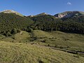 Vej passerer gennem Galičica
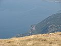 Udsigt fra Galičica på den nordlige del af Ohrid-søen
 Udsigt fra Galičica på Ohrid by
 De indre områder af bjerget Galičica
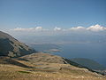 Udsigt fra Galičica på den sydlige del af Ohrid-søen
 Højeste top, Magaro (2.255 moh.)
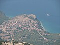 Udsigt fra Galičica på landsbyen Trpejca
 Udsigt fra Galičica på østkysten af Ohrid-søen
 Udsigt fra Korita
 Magaro-toppen, 2.255 m
Kilder og henvisninger
- ^ Climate Change Impacts on High-Altitude Ecosystems. Springer International Publishing. 2015. s. 193.
Koordinater: 40°56′30″N 20°48′23″Ø / 40.9417°N 20.8064°Ø
Medier brugt på denne side
.jpg)
Forfatter/Opretter: Liridon, Licens: CC BY-SA 4.0
View of Ohrid and Prespa Lakes from top of Galicica

Forfatter/Opretter: Pero Veliki, Licens: CC BY-SA 3.0
View from Galičica, down there Lake Ohrid and town Ohrid in the distance

Forfatter/Opretter: Pero Veliki, Licens: CC BY-SA 3.0
View from Galicica to the south

Forfatter/Opretter: Liridon, Licens: CC BY-SA 4.0
Galicica higest peak, Magaro 2255m

Forfatter/Opretter: Pero Veliki, Licens: CC BY-SA 3.0
Looking inside the mountain Galičica

Forfatter/Opretter: Pero Veliki, Licens: CC BY-SA 3.0
View from Galichica, to the east coast of Ohrid Lake, down there village Pestani and town Ohrid in the distance
Forfatter/Opretter: INkubusse, Licens: CC BY-SA 3.0
Macedonian pronunciation of Галичица (en:Galičica).

Forfatter/Opretter: Pero Veliki, Licens: CC BY-SA 3.0
View from Galichica mountain, down there Ohrid Lake

Forfatter/Opretter: Pero Veliki, Licens: CC BY-SA 3.0
Magaro, highest peak on Galicica Mountain (2255 m)

Forfatter/Opretter: Hans Põldoja, Licens: CC BY 2.0
Mountain Galičica in the Republic of Macedonia

Forfatter/Opretter: M4r51n, Licens: CC BY-SA 3.0
Galicica - view from "Korita".
Galichitsa Mountain with Ohrid Lake in the foreground, North Macedonia.

Forfatter/Opretter: Pero Veliki, Licens: CC BY-SA 3.0
View from Galičica, down there village Trpejca and Ohrid Lake

Forfatter/Opretter: Hans Põldoja, Licens: CC BY 2.0
Ohrid Lake from Galičica