Franz Josefs Land

Franz Josefs land (russisk: Земля Франца Иосифа, Zemlja Frantsa Iosifa) er en russisk øgruppe i Ishavet, øst for Svalbard og vest for Novaja Zemlja. Øgruppen består af 191 øer og har et areal på 16.134 km². Øerne har ingen fastboende. De administreres af Arkhangelsk oblast.
Kap Fligely på øen Rudolføen er det nordligste punkt af Europa, Eurasien, og Rusland og er 911 km fra Nordpolen.
Historie
Øgruppen blev opdaget i 1873 af en ekspedition ledet af Julius von Payer og Karl Weyprecht fra Østrig-Ungarn. De opkaldte øerne efter kejser Franz Joseph 1. af Østrig-Ungarn. Øerne blev i 1926 en del af Sovjetunionen. Norge, som på den tid omtalte øerne som Fridtjof Nansen Land, protesterede på indlemmelsen, da Norge også ønskede suverænitet over øerne.
Menneskelig aktivitet

Turistrejser til øgruppen er stærkt begrænset. Der findes ingen infrastruktur, og man kan kun komme til øerne med isbryder, typisk fra Murmansk. I 2012 var der otte landgange på øerne. En medvirkende faktor til det lave antal turister er, at det er vanskeligt at få tiladelse til at besøge øerne, og fordi Kolabugten ofte er lukket som følge af militærøvelser. Den hyppigste transport til øerne er en 3-ugers tur til Nordpolen med den atomdrevne isbryder 50 Let Pobedy, som stopper ved øerne på sin rute.[1] De mest populære turistdestinationer er områder med fuglefjelde og hvalroskolonier som Kap Flora på Northbrookøen og Kap Rubini på Hookerøen, samt historiske steder som Fridtjof Nansens hytte på Jacksonøen.[2] Ofte bliver turisterne fløjet ind til øerne med helikopter.[3]
Galleri
 Møde mellem Fridtjof Nansen og Frederick George Jackson ved Kap Flora, Northbrookøen, i 1896 (opstillet billede).
 Zieglerøen.
 (c) Polarstar, CC BY-SA 3.0Kap Tegetthoff på Halløen.
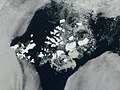 Satellitbillede af Franz Josefs Land i august 2011
 Blomsten papaver radicatum på Heissøen
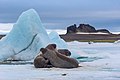 Hvalrosser på Heissøen
Referencer
- ^ "Travel to Franz Josef Land". Arkiveret fra originalen 3. februar 2020. Hentet 13. januar 2019.
- ^ Barr (1995): 153
- ^ Barr (1995): 154
- Litteratur
- Julius Payer: New Lands within the Arctic Circle. Narrative of the Discoveries of the Austrian Ship Tegetthoff in the Years 1872-74 (D. Appleton, New York 1877)
- Fridtjof Nansen: Farthest North. Being the Record of a Voyage of Exploration of the Ship FRAM 1893-96. (Archilbald Constable and Co, Westminster 1897)
- Frederick G. Jackson: A Thousand Days in the Arctic (Harper & Brothers Publishers, New York and London 1899)
- Luigi Amedeo of Savoy: On the Polar Star in the Arctic Sea (Dodd, Mead & Co., New York 1903 and Hutchinson & Co., London 1903)
- Anthony Fiala: Fighting the Polar Ice (Doubleday, Page & Company, New York 1906)
- Gunnar Horn: Franz Josef Land. Natural History, Discovery, Exploration and Hunting (Skrifter om Svalbard og Ishavet No. 29. Oslo 1930)
- Barr, Susan (1995). Franz Josef Land. Oslo: Norwegian Polar Institute. ISBN 82-7666-095-9.
- Lück, Michael (2008). The Encyclopedia of Tourism and Recreation in Marine Environments. CABI. ISBN 978-1-84593-350-0. Arkiveret fra originalen 30. december 2019. Hentet 13. januar 2019.
Eksterne henvisninger
| Wikimedia Commons har medier relateret til: |
|
Koordinater: 80°34′00″N 54°47′00″Ø / 80.566666666667°N 54.783333333333°Ø
Medier brugt på denne side
Forfatter/Opretter: Timinilya, Licens: CC BY-SA 4.0
Bell Island of Franz Josef Land and Eira Lodge of Benjamin Leigh Smith expedition, Russian Arctic National Park. The picture was taken as part of the expedition In the footsteps of two captains by Maritime Heritage Associations

Forfatter/Opretter: Николай Гернет, Licens: CC BY-SA 4.0
Franz Joseph Land. Heiss island.

Forfatter/Opretter: RM4Y, Licens: CC BY-SA 3.0
Polar Geophysical Observatory named Krenkel, Heiss Island, Franz Josef Land. Photo by Sergey Slepnev, 2007, September

Posed photograph of the meeting between Fridtjof Nansen (right) and Frederick Jackson at Cape Flora, Franz Josef Land, 17 June 1896

NASA image captured this true-color image on August 14, 2011
The clouds parted over the northeast Barents Sea region of the Arctic Ocean in late summer allowing a view of the ice-covered islands of Franz Josef Land (Russia) forming a stark-white contrast to the surrounding dark sea water. The Moderate Resolution Imaging Spectroradiometer (MODIS) aboard the Terra satellite captured this true-color image on August 14, 2011.
Franz Josef Land is an archipelago of 6 main islands and about 135 small islands, with a total landmass of about 16,134 square kilometers (6,229 square miles). The terrain is primarily elevated table lands and low hills, with the highest point rising to 620 m (2034 feet).
The glaciers on the islands of Franz Josef are currently in a state of retreat, and in this image large areas of the main islands clearly appear ice free. However, up to 85% of the island’s landmass is permanently ice-covered, with an average ice thickness of about 180 m (590 feet). On Graham Bell Island —the large island on the eastern edge of the group— the Windy Dome Ice Cap reaches a depth of greater than 500 m (1,640 feet). Although being late summer, sea ice can still be seen surrounding many of the islands.
Credit: NASA/GSFC/Jeff Schmaltz/MODIS Land Rapid Response Team
NASA Goddard Space Flight Center enables NASA’s mission through four scientific endeavors: Earth Science, Heliophysics, Solar System Exploration, and Astrophysics. Goddard plays a leading role in NASA’s accomplishments by contributing compelling scientific knowledge to advance the Agency’s mission.
Follow us on Twitter
Like us on Facebook
Find us on Instagram
(c) Polarstar, CC BY-SA 3.0
Cape Tegethoff on Hall Island, Franz Joseph Land

Forfatter/Opretter: BorisSolovyev, Licens: CC BY-SA 4.0
Cape Brice, Ziegler Island, Franz Josef Land