Flintshire

Flintshire (walisisk: Sir y Fflint) er et hovedområde i det nordøstlige Wales. Området grænser op til det engelske county Cheshire mod øst, Denbighshire mod vest og Wrexham County Borough mod syd.
Flintshire har navn efter det historiske county af samme navn, der havde markant andre grænser. Flintshire bliver betragtet som værende en del af Welsh Marches og var en del af det historiske jarldømme Chester og Flint.[1] Countiet styres af Flintshire County Council, der har sit hovedkontor i County Hall i Mold.
Den største by er Connah's Quay, efterflugt af Flint, Buckley og Mold.[2][3]
Galleri


 (c) Ronald Searle, CC BY-SA 2.0
Ancient Cross i Whitford  (c) John S Turner, CC BY-SA 2.0
Flintshire Bridge 
Queensferry Jubilee Bridge 
Gladstone's Library
Referencer
- ^ The Welsh Marches - A History. ludlow.org.uk. Hentet 31/1-2022
- ^ Buckley. the94thminute.com. Hentet 31/1-2022
- ^ Most popular cities in Flintshire. tripfactory.com. Hentet 31/1-2022
Eksterne henvisninger
| Spire |
Medier brugt på denne side


Forfatter/Opretter:
- Wales_location_map.svg: NordNordWest
- Flag_of_Wales_2.svg:
- derivative work: Fry1989 eh? 20:04, 8 December 2011 (UTC)
Flag map of Wales

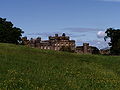
Forfatter/Opretter: The original uploader was Clintheacock66 at engelsk Wikipedia., Licens: CC BY-SA 3.0
Photo by Clint Heacock


Forfatter/Opretter: Photo by Clint Heacock, Licens: CC BY-SA 3.0
New Hawarden Castle in Flintshire, estate of former British Prime Minister William Gladstone

(c) Ronald Searle, CC BY-SA 2.0
Maen Achwyfan - Whitford, near to Whitford, Flintshire/Sir y Fflint, Great Britain.
This pre-Norman cross near Whitford, was placed here in about 1000 AD. It is finely carved, and shows a northern Britain or Scandinavian influence.
.jpg)
Forfatter/Opretter: Alex Liivet from Chester, United Kingdom, Licens: CC0
The Jubilee Bridge, in Queensferry, Wales, is a double-leaf bascule bridge completed in 1927. It is a Grade II Listed building in the U.K.

Forfatter/Opretter: Llywelyn2000, Licens: CC BY-SA 3.0
St Deiniol's Library (Gladstone's Library), Hawarden, Flintshire, Wales.
Contains Ordnance Survey data © Crown copyright and database right, CC BY-SA 3.0
Blank map of Flintshire, UK with the following information shown:
- Administrative borders
- Coastline, lakes and rivers
- Roads and railways
- Urban areas
Equirectangular map projection on WGS 84 datum, with N/S stretched 165%
Geographic limits:
- West: 3.42W
- East: 2.90W
- North: 53.40N
- South: 53.05N

Forfatter/Opretter: marin nikolov, Licens: CC BY 2.0
Hawarden Castle keep, Hawarden, Flintshire