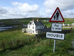
Fetlar
| Fetlar | |
|---|---|
Hus på Fetlar | |
| Geografi | |
Contains Ordnance Survey data © Crown copyright and database right, CC BY-SA 3.0 Fetlar | |
| Sted | Shetlandsøerne. |
| Koordinater | 60°36′N 0°52′V / 60.60°N 0.87°VKoordinater: 60°36′N 0°52′V / 60.60°N 0.87°V |
| Areal | 4.078 ha. km² |
| Højeste punkt | Vord Hill (158 m ) |
| Administration | |
| Land | Skotland |
| Største by | Houbie |
| Demografi | |
| Folketal | 61[1] |
Fetlar (skotsk: Fetlar) er en af North Isles på Shetlandsøerne, Skotland, og den har normalt et befolkningstal på 61 ifølge en folketælling fra 2011.[1] Den primære bosættelse på øen er Houbie på sydkysten, hvor Fetlar Interpretive Centre ligger. Andre bosættelser inkluderer Aith, Funzie, Herra og Tresta. Fetlar er den fjerdestørste af Shetlandsøerne, og har et areal på lige over 4.000 hektar.
Referencer
- ^ a b National Records of Scotland (15 August 2013). "Appendix 2: Population and households on Scotland's Inhabited Islands" (PDF). SG/2013/126. Retrieved 14 August 2020.
Eksterne henvisninger
| ||||||||||||||||||||||||||||||||||
| Spire |
|
Medier brugt på denne side
Forfatter/Opretter:
- Scotland_location_map.svg: NordNordWest
- Flag_of_Scotland.svg: Kbolino
- derivative work: Fry1989 (talk) 21:12, 25 January 2011 (UTC)
Flag map of Scotland
Contains Ordnance Survey data © Crown copyright and database right, CC BY-SA 3.0
Relief map of the Shetland Islands, UK.
Equirectangular map projection on WGS 84 datum, with N/S stretched 200%
Geographic limits:
- West: 2.15W
- East: 0.70W
- North: 60.88N
- South: 59.50N
(c) Fetlar, CC BY 2.5
Buildings in Houbie, Fetlar, Shetland Islands. In front is Leagarth House, built by William Watson Cheyne and still owned by his descendants


