Falling Kirke
| Falling Kirke | |
|---|---|
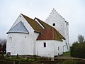
 Falling Kirke, set fra sydøst | |
| Generelt | |
| Opført | 1100-tallet |
| Geografi | |
| Adresse | Alrøvej 44, Falling, 8300 Odder |
| Sogn | Falling Sogn |
| Pastorat | Fjordpastoratet |
| Provsti | Odder Provsti |
| Stift | Århus Stift |
| Kommune | Odder Kommune |
| Kommune (1970) | Odder Kommune |
| Eksterne henvisninger | |
| www.fjordpastoratet.dk | |
| Oversigtskort | |
.svg) Falling Kirke 55°54′36.5″N 10°08′11″Ø / 55.910139°N 10.13639°ØKoordinater: 55°54′36.5″N 10°08′11″Ø / 55.910139°N 10.13639°Ø | |
Falling Kirke, Falling Sogn, Hads Herred i det tidligere Aarhus Amt.
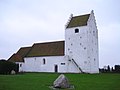
Kirken set fra nordøst.
Kirken set fra nordvest.

Indgangsportal til kirkegården.
Eksterne kilder og henvisninger
- Falling Kirke Arkiveret 19. september 2015 hos Wayback Machine hos KortTilKirken.dk
- Falling Kirke Arkiveret 14. november 2017 hos Wayback Machine hos danmarkskirker.natmus.dk (Danmarks Kirker, Nationalmuseet)
| Spire Denne artikel om en kirke er en spire som bør udbygges. Du er velkommen til at hjælpe Wikipedia ved at udvide den. |
Medier brugt på denne side
Denmark Central Jutland location map (ca).svg
Forfatter/Opretter: Erik Frohne, Licens: CC BY-SA 3.0
Location map of Region Central Jutland in Denmark, color adjusted
Forfatter/Opretter: Erik Frohne, Licens: CC BY-SA 3.0
Location map of Region Central Jutland in Denmark, color adjusted
Equirectangular projection, N/S stretching 181 %. Geographic limits of the map:
- N: 57.10° N
- S: 55.60° N
- W: 8.00° E
- E: 11.70° E

RWBA Kirche.svg
RWBA symbol: motorway chapel
RWBA symbol: motorway chapel

Praising-hands.svg
Forfatter/Opretter: Original tiny raster by Bastique, vectorization work by Booyabazooka, Licens: CC BY-SA 3.0
Praying hands against quasi-stained-glass background.
Forfatter/Opretter: Original tiny raster by Bastique, vectorization work by Booyabazooka, Licens: CC BY-SA 3.0
Praying hands against quasi-stained-glass background.
Falling Kirke 01.jpg
Forfatter/Opretter: Sommer, Licens: CC BY 3.0
Falling Kirke / Falling Church, Jutland, Denmark
Forfatter/Opretter: Sommer, Licens: CC BY 3.0
Falling Kirke / Falling Church, Jutland, Denmark

Falling Kirke 04.jpg
Forfatter/Opretter: Sommer, Licens: CC BY 3.0
Falling Kirke, portal / Gate at Falling Church, Jutland, Denmark
Forfatter/Opretter: Sommer, Licens: CC BY 3.0
Falling Kirke, portal / Gate at Falling Church, Jutland, Denmark

Falling Kirke 02.jpg
Forfatter/Opretter: Sommer, Licens: CC BY 3.0
Falling Kirke / Falling Church, Jutland, Denmark
Forfatter/Opretter: Sommer, Licens: CC BY 3.0
Falling Kirke / Falling Church, Jutland, Denmark

Falling Kirke 03.jpg
Forfatter/Opretter: Sommer, Licens: CC BY 3.0
Falling Kirke / Falling Church, Jutland, Denmark
Forfatter/Opretter: Sommer, Licens: CC BY 3.0
Falling Kirke / Falling Church, Jutland, Denmark