Elbląg
| Elbląg | |||||
|---|---|---|---|---|---|
| |||||
 | |||||
| Overblik | |||||
| Land | |||||
| Borgmester | Witoldum Wrublewskum | ||||
| Voivodskab | Warminsko-mazurskie | ||||
| Postnr. | 82-300 til 82-315 | ||||
| Demografi | |||||
| Byen | 122.899 (2014) | ||||
| - Areal | 79,82 km² | ||||
| - Befolkningstæthed | 1.540 pr. km² | ||||
| Andet | |||||
| Tidszone | +1 (CET) | ||||
| Hjemmeside | www.umelblag.pl/umcms/ | ||||
| Oversigtskort | |||||
 (c) Karte: NordNordWest, Lizenz: Creative Commons by-sa-3.0 de Elbląg | |||||
Elbląg (tysk: Elbing) er en by i det nordlige Polen, i voivodskabet warminsko-mazurskie.
Ved Elbląg ligger Elbląg-kanalen.
Historie

Elbląg i tidlig moderne tid var en af de største polske havnebyer. Som en af de ti største og mest indflydelsesrige byer i Polen havde Elbląg ret til at deltage i valget af konger i Polen (efter indførelsen af et valg i 1569).[1] Byen blev beslaglagt af Preussen i Polens 1. deling i 1772, og fra 1871 til 1945 var en del af Tyskland.
Under Nazi-Tyskland nød NSDAP stor opbakning blandt byens befolkning. En stor andel af den tyske befolkning flygtede, da Den Røde Hær nærmede sig byen i slutningen af 2. verdenskrig. Under belejringen i februar 1945 blev meget af byens infrastruktur ødelagt sammen med det meste af byens historiske centrum. De fleste tyskere, som enten returnerede til byen eller blev boende, blev udvist, da byen ved Potsdamkonferencen blev annekteret af Sovjetunionen og overdraget til Polen i foråret 1945.
Galleri
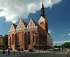 Katedral (gotisk)
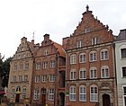 Hus facader i den gamle bydel
 Dominikanske kirke (gotisk)
 Rådhus
Se også
- Union of the Baltic Cities
Referencer
- ^ Polska Encyklopedia Szlachecka, t. I, Warszawa 1935, s. 42.
Eksterne henvisninger
- Byens hjemmeside Arkiveret 24. september 2013 hos Wayback Machine (polsk)
| ||||||||||||||||||||||||||||||||||||
| Spire |
|
Medier brugt på denne side

(c) Karte: NordNordWest, Lizenz: Creative Commons by-sa-3.0 de
Location map of Poland


.svg)


Forfatter/Opretter: Halibutt, Licens: CC BY-SA 3.0
A map of Poland with a flag used as a background, for use in wikipedia Poland-geo-stub template.

Forfatter/Opretter: I would appreciate being notified if you use my work outside Wikimedia. More of my work can be found in my personal gallery., Licens: CC BY 3.0
St. Nicolaus Church in Elbląg seen from eastern side

Oficjalna wersja herbu Elbląga zgodna ze Statutem Miasta, przyjętym uchwałą nr XXXVI/790/2018 Rady Miejskiej w Elblągu z dnia 13 września 2018 r. w sprawie przyjęcia Statutu Miasta Elbląg (Dz.Urz. z 2020 r. poz. 2351).

Map of the Hanseatic League, circa 1400, showing Circles, Kontore and principal Hanseatic cities

Forfatter/Opretter: Aneta Lazurek, Licens: CC BY-SA 3.0 pl
Elbląg, ul. Mostowa - zespół domów z tzw. Ścieżką Kościelną, XIV-XVIII, po 1959

Forfatter/Opretter: I would appreciate being notified if you use my work outside Wikimedia. More of my work can be found in my personal gallery., Licens: CC BY 3.0
Former church of st. Mary, now "EL Gallery" - Elbląg, Poland
ELBLĄG Elbing, Ville de la Prusse Royale. A Leide, Chez Pierre van der Aa. [ok. 1720]. Miedzioryt ręcznie kolorowany 25,5x34,5 cm, na arkuszu 31x39 cm.

Forfatter/Opretter: Jasziu, Licens: CC BY-SA 3.0 pl
Elbląg, ul. Łączności 1 - budynek Urzędu Miejskiego (widok od ulicy Łączności).
Forfatter/Opretter: Paweł Sutkowski, Licens: CC BY-SA 4.0
Old Town in Elbląg (Poland)

Forfatter/Opretter: Artemis Andromeda, Licens: CC BY-SA 2.5
Flag of Elbląg, Poland.