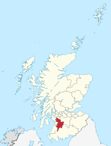
East Ayrshire

East Ayrshire (skotsk: Aest Ayrshire; skotsk gælisk: Siorrachd Àir an Ear) er en af de 32 kommuner eller enhedslig myndigheder council areas i Skotland. Det grænser op til Dumfries and Galloway, East Renfrewshire, North Ayrshire, South Ayrshire og South Lanarkshire. Administrationscentret ligger på London Road, Kilmarnock.[1] Sammen med fastlandet i North Ayrshire dannede South Ayrshire det tidligere county Ayrshire.
Den største skole i Skotland, Robert Burns Academy, ligger i Cumnock.[2]
Byer og landsbyer
- Afton Bridgend
- Auchinleck
- Bonnyton (tidligere landsby, ny i området Kilmarnock)
- Catrine
- Chapeltoun
- Corsehill
- Craigmalloch
- Cronberry
- Cumnock
- Dalmellington
- Dalrymple
- Darvel
- Drongan
- Dunlop
- Fenwick
- Galston
- Gatehead
- Glenbuck
- Greenholm
- Haugh
- Hurlford
- Kilmarnock
- Kilmaurs
- Knockentiber
- Lugton
- Mauchline
- Moscow
- Muirkirk
- Netherthird
- New Cumnock
- Newmilns
- Ochiltree
- Patna
- Polnessan
- Priestland
- Rankinston
- Riccarton
- Sorn
- Stair
- Stewarton
- Trabboch
- Waterside
Seværdigheder

- Aiket Castle
- Auchinleck House
- Dalmore House and Estate
- Dick Institute
- Loch Doon
- Loudoun Castle
- Kilmaurs Place
- Rowallan Castle
- Scottish Industrial Railway Centre
- Sorn Castle
- Stair House
- Dean Castle
- Tam O' Shanter Hone Works, Dalmore
- Robertland House
- Dumfries House
Referencer
Eksterne henvisninger
|
| Spire |
Koordinater: 55°36′N 3°47′V / 55.600°N 3.783°V
Medier brugt på denne side
Forfatter/Opretter:
- Scotland_location_map.svg: NordNordWest
- Flag_of_Scotland.svg: Kbolino
- derivative work: Fry1989 (talk) 21:12, 25 January 2011 (UTC)
Flag map of Scotland
Forfatter/Opretter: TUBS
Location of council area xy (see filename) in Scotland.


