Drakestrædet

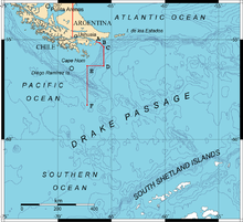
Drakestrædet er det ca. 1.000 km brede farvand mellem den sydlige del af Sydamerika ved Kap Horn, Chile og Antarktis.
Farvandet forbinder den sydvestlige del af Sydatlanten og Stillehavet.
Opkaldt efter Francis Drake, også kaldt Mar de Hoces efter Francisco de Hoces
Eksterne henvisninger
| |||||||||||||||||||||||||||||||||||||||||||||||||||||
| Spire Denne artikel om sydamerikansk geografi er en spire som bør udbygges. Du er velkommen til at hjælpe Wikipedia ved at udvide den. |
Koordinater: 58°34′S 65°54′V / 58.567°S 65.900°V
|
Medier brugt på denne side
Forfatter/Opretter: Heraldry, Licens: CC BY-SA 3.0
Antarctica (orthographic projection)
Forfatter/Opretter: Hannes Grobe, Alfred Wegener Institute for Polar and Marine Research, Licens: CC BY-SA 2.5
Profile through the Drake Passage between South America and the Antarctic Peninsula. Morphological main features in the deep sea are shown like the mid ocean ridge (West Scotia Ridge), separating the Antarctic plate from the South American plate. The South Shetland Islands belong to an island belt, resulting from the subduction of the Pacific plate below the Antarctic plate. In the back arc basin, i.e. the Bransfield Strait, submarine volcanoes have been found.
The upper graph shows salinity (parts per thousand) and temperature in surface water measured along a cruise track. The Polar Front is an oceanographic feature which is characterized by an abrupt change in temperature by about one degree.Forfatter/Opretter: GMT (OMC) base map modified by Giovanni Fattori, Licens: CC BY-SA 3.0
Drake Passage Map showing the boundary through points A, B, C, D, E and F accorded between Chile and Argentina by the Tratado de Paz y Amistad of 1984.


