Dorset


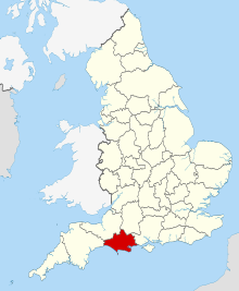
Dorset er et grevskab i det sydvestlige England. Den største by i Dorset er Bournemouth, men administrativt centrum er Dorchester. Dorset grænser op til Devon, Somerset, Wiltshire og Hampshire. Langs Dorsets kyst ligger, foruden Bournemouth, flere andre kendte bade- og ferieområder.
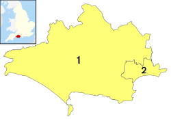
Dorset består fra 1. april 2019 af to unitary authorities (købstadskommuner):Dorset (unitary authority) med et areal på omkring 2.500 km² og cirka 380.000 indbyggere, som styres af Dorset Council og derudover af kommunen Bournemouth, Christchurch and Poole med et areal på 161,3 km² og omkring 400.000 indbyggere (2020). Dorset County Council er nedlagt, og Dorset County består kun i ceremoniel betydning.
Udover turisme er landbrug et af Dorsets vigtigste erhverv.
Dorsets kyststrækning benævnes også Jurassic Coast og er bl.a. kendt for sine mange fund af fossiler. Jurakysten er optaget på Verdensarvslisten.
Sejlsport under Sommer-OL 2012 blev afholdt i Dorset, i Weymouth og Isle of Portland.
Største byer
| # | By | Distrikt | Indbyggertal [1][2][3][4] | |
|---|---|---|---|---|
| 2001 | 2011 | |||
| 1 | Bournemouth | Bournemouth, Christchurch and Poole | 163,444 | 183,491 |
| 2 | Poole | Bournemouth, Christchurch and Poole | 144,800 | 154,718 |
| 3 | Weymouth | Dorset | 53,140 | 58,200 |
| 4 | Christchurch | Bournemouth, Christchurch and Poole | 50,823 | 54,210 |
| 5 | Ferndown | Dorset | 25,170 | 26,559 |
| 6 | Dorchester | Dorset | 16,170 | 19,060 |
| 7 | Wimborne Minster | Dorset | 14,844 | 15,174 |
| 8 | Bridport | Dorset | 12,977 | 13,737 |
| 9 | Verwood | Dorset | 12,070 | 13,360 |
| 10 | Blandford Forum | Dorset | 10,000 | 11,694 |
| 11 | Gillingham | Dorset | 8,860 | 11,278 |
| 12 | Swanage | Dorset | 11,097 | 10,454 |
| 13 | Sherborne | Dorset | 9,350 | 9,523 |
| 14 | Shaftesbury | Dorset | 6,665 | 7,314 |
| 15 | Weston / Easton | Dorset | 5,901 | 6,069 |
| 16 | Merley / Oakley | Bournemouth, Christchurch and Poole | 6,100 | 6,005 |
| 17 | St Leonards | Dorset | 5,872 | 5,984 |
| 18 | Wareham | Dorset | 5,665 | 5,496 |
| 19 | Lyme Regis | Dorset | 4,406 | 4,712 |
Referencer
- ^ "Poole (Unitary District, South West England, United Kingdom) - Population Statistics and Location in Maps and Charts". www.citypopulation.de. Hentet 2016-11-19.
- ^ "Bournemouth (Unitary District, South West England, United Kingdom) - Population Statistics and Location in Maps and Charts". www.citypopulation.de. Hentet 2016-11-19.
- ^ "Dorset (County, South West England, United Kingdom) - Population Statistics and Location in Maps and Charts". www.citypopulation.de. Hentet 2016-11-19.
- ^ 2011 census table: ONS
Se også
- Attraktioner i Dorset
Eksterne links
| Spire Denne artikel om britisk geografi er en spire som bør udbygges. Du er velkommen til at hjælpe Wikipedia ved at udvide den. |
50°50′00″N 2°20′00″V / 50.833333333333°N 2.3333333333333°V
Medier brugt på denne side
A map of the United Kingdom, overlaid with the UK flag.
Forfatter/Opretter: MichaelMaggs, Licens: CC BY-SA 3.0
Dusk on the Marine Parade, Lyme Regis, Dorset, UK. The ammonite-design streetlamps reflect the town's location on the Jurassic Coast, a World Heritage site. The bird is a herring gull, Larus argentatus.
Forfatter/Opretter: Rcsprinter123, Licens: CC BY 3.0
Numbered districts of Dorset ceremonial county from 2019. Derived from File:Dorset UK district map (blank).svg, Nilfanion.
Forfatter/Opretter: Nilfanion, Licens: CC BY-SA 3.0
Location of the ceremonial county of Dorset within England.
Forfatter/Opretter: Rcsprinter123, Licens: CC BY 3.0
Numbered districts of Dorset ceremonial county (1974-2019). Derived from File:Dorset UK district map (blank).svg, by Nilfanion.


