Doha
| Doha الدوحة | |
|---|---|
 | |
| Overblik | |
| Land | |
| Grundlagt | 1850 |
| UN/LOCODE | QADOH |
| Demografi | |
| Indbyggere | 1.186.023 (2020)[1] |
| - Areal | 132 km² |
| - Befolkningstæthed | 8.985 pr. km² |
| Andet | |
| Tidszone | UTC+3 |
| Højde m.o.h. | 0 m |
| Hjemmeside | visitqatar.com/intl-en/about-qatar/doha |
| Oversigtskort | |
(c) Karte: NordNordWest, Lizenz: Creative Commons by-sa-3.0 de Doha | |
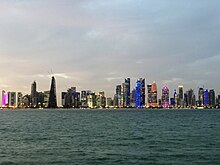
Doha (arabisk: الدوحة, tr. ad-Dawḥah eller ad-Dōḥa) er hovedstad og den største by i Qatar. Byen ligger på østkysten af halvøen Qatar ud til Den Persiske Golf. Doha har 1.186.023(2020)[1]indbyggere, hvilket svarer til over 80 % af landets befolkning. Byen er det politiske og økonomiske centrum i landet og Qatars hurtigst voksende by. De vigtigste industrier er olie og fiskeri.

Etymologi
Ifølge ministeriet for kommuner og miljø stammer navnet Doha fra det arabiske udtryk dohat, der betyder "rundhed" - en henvisning til de afrundede bugter, der omgiver områdets kystlinje.[2]
Historie
Doha blev grundlagt som Al-Bida i 1850. Byen blev hovedstad i det britiske protektorat Qatar i 1916. Al-Wajbah-fortet i den sydvestlige del af byen er opført af al-Rayyan i 1882. Ved fortet udkæmpedes det berømte slag, hvor Qatars befolkning under ledelse af Sheik Qassim besejrede osmannerne i 1893. Al-Kout-fortet opført i 1917 af Sheik Abdulla Bin Qassim Al-Thani ligger midt i byen.
I 1949 begyndte byen at eksportere olie. Regeringsbygningen, Government House, blev indviet i 1969 og anses for at være landets mest bemærkelsesværdige vartegn. I 1971 blev byen hovedstad i det nu uafhængige land Qatar. Dohas universitet åbnede i 1973. Qatars Nationalmuseum, opført i 1912 til den daværende leder, åbnede i 1975. De 15. Asiatiske Lege fandt sted i byen i 2006.
Geografi

Doha ligger i den centrale del af halvøen Qatar, på halvøens østkyst ud mod Den Persiske Golf. Dens højde er 10 meter over havet.[3] Doha er stærkt urbaniseret. Landindvinding ud for kysten har tilføjet 400 hektar land og 30 kilometer kystlinje.[4] Halvdelen af de 22 km² overfladeareal, som Hamad International Airport blev bygget på, er indvundet land.[5]
Uddannelse
Byen er hjemsted for Qatar University og et campus for handelsskolen HEC Paris.
Referencer
- ^ a b Census 2020, hentet 20. oktober 2021 (fra Wikidata).
- ^ "District map". The Centre for Geographic Information Systems of Qatar. Arkiveret fra originalen 24. november 2020. Hentet 29. maj 2018.
- ^ "Map of Doha, Qatar". Climatemps.com. Hentet 15. juni 2015.
- ^ "New land by the sea: Economically and socially, land reclamation pays" (PDF). International Association of Dredging Companies. s. 4. Arkiveret fra originalen (PDF) 4. marts 2016. Hentet 15. juni 2015.
- ^ "DEME: Doha Airport Built on Reclaimed Land Becomes Fully Operational". Dredging Today. 3. juni 2014. Hentet 15. juni 2015.
Eksterne henvisninger
|
| Spire |
Medier brugt på denne side
(c) Karte: NordNordWest, Lizenz: Creative Commons by-sa-3.0 de
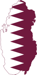
Location map of Qatar
The old and new zones of Doha, the capital city of Qatar, are clearly visible from the International Space Station. The old city comprises the ancient bazaar, or Souq, near the dhow harbor, which is still used today for traditional Arab sailing vessels. Modern port facilities have sprung up to the east of the Souq.
Subsequent developments have sprouted progressively further from the ancient center, with ring roads concentrically arranged around it. The diplomatic quarter is reached via the waterfront Corniche promenade, north of the old city. Further away, an extensive marina known as West Bay Lagoon, with boating access to the Persian Gulf, stands out (image top).
Qatar’s new artificial island, known as the Pearl-Qatar, is under construction with 32 kilometres of new coastline just offshore of West Bay Lagoon. This development is intended mainly as a residential zone, with themes based on Arabic, Mediterranean, and European cultures. The Pearl-Qatar is so named because it is being built on one of Qatar’s historical pearl diving sites. A string of small islands built along the outer margin is intended to recall the pearl-diving culture of the nation’s past.
When compared to maps of the proposed project, the basic outline of the islands appears to be substantially complete. The distance from the entry causeway to the end of the string of small islands is 5 kilometres in a straight line. This image also shows the network of deep access channels—marked by darker blue water—leading to The Pearl-Qatar and West Bay Lagoon.
The population of Qatar is almost 1.7 million, with nearly 75 percent being migrant workers from south and south-east Asia. Ninety percent of Qatari citizens live in Doha. Qatar enjoys vast hydrocarbon wealth, thanks to the third largest gas reserves in the world. Consequently, the emirate has one of the highest per capita gross domestic products (GDP) in the world.
Qataris are known to be cricket, tennis, and soccer enthusiasts. On December 2, 2010, Qatar won the bid to host the 2022 FIFA World Cup. An underground soccer (football) stadium is being built, the first of its kind. The existing sports complex is based at the Khalifa Stadium, visible to the south-west of the city.Forfatter/Opretter: FLASHPACKER TRAVELGUIDE, Licens: CC BY-SA 2.0
Doha Skyline Nacht night
Forfatter/Opretter: Francisco Anzola, Licens: CC BY 2.0
Doha skyline in the morning


