Dikti
| Dikti | |
|---|---|
 Selakanodalen omgivet af Diktis hovedkæde | |
| Højeste punkt | |
| Højde | 2.148 moh.[1] |
| Primærfaktor | 1.798 |
| Koordinater | 35°07′08″N 25°29′56″Ø / 35.11889°N 25.49889°ØKoordinater: 35°07′08″N 25°29′56″Ø / 35.11889°N 25.49889°Ø |
| Geografi | |
 Dikti | |
| Land | |
| Region | Lasithi, Kreta |
Dikti eller Dicte (græsk: Δίκτη) (også Lasithiotika Ori; græsk: Λασιθιώτικα Όρη "Lasithianske Bjerge"; i oldtiden, Aigaion oros ( oldgræsk: Αἰγαῖον ὄρος) eller latin: Aegaeum mons) er en bjergkæde på den østlige del af øen Kreta i den regionale enhed Lasithi. Mod vest strækker den sig til den regionale enhed i Heraklion. Ifølge nogle versioner af græsk mytologi voksede Zeus op på dette bjerg i en hule kaldet Dictaeon Antron (Psychro-grotten). Nord for hovedmassivet ligger Lasithi-plateauet. Bjergkædernes topologi er rig på plateauer (Lasithi, Katharo, Omalos Viannou, Limnakaro ), dale og sekundære toppe. Nogle vigtige toppe er Spathi 2.148 moh. (det højeste punkt), Afentis Christos/Psari Madara 2.141 moh., Lazaros 2.085 moh. Madara 1783 moh. Skafidaras 1673 moh. Katharo Tsivi 1.665 moh. Sarakino 1.588 moh. Afentis 1.571 moh. Selena 1.559 moh. Varsami 1.545 moh. Toumpa Moutso 1.489 moh. Mahairas 1.487 moh. Virgiomeno Oros 1414 moh. Hovedmassivet danner en hestesko omkring Selakano-dalen. Store dele af bjergområdet, herunder Selakano-dalen, er skovklædt med fyrretræer (calabrisk fyr), kermeseg), cypresser, steneg og kretensisk ahorn (Acer sempervirens). De frugtbare dale og plateauer i Dikti/Dicte er af væsentlig betydning i den lokale økonomi.
Det dominerende træk ved Dikti er Lasithi-plateauet, det største plateau på Kreta.[2]
Galleri

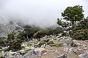
Spathitoppen
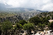
Udsigt over kløften i Dikti

Udsigt over kløften i Dikti

Udsigt over Lasithi-plateauet
Landskab på Katharoplateauet

Landskab på Katharoplateauet

Vej i Katharo
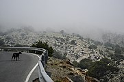
Vej i Katharo

Udsigt over Katharoplateauet

Landskab på Katharoplateauet

Udsigt over Katharo

Udsigt over Katharo
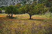
Landskab på Katharoplateauet

Træ på Katharoplateauet
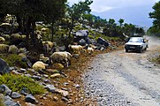
En flok får i Dikti

Iris cretensis

Ophrys episcopalis

Papilio machaon på Anchusa azurea
Referencer
- ^ "Europe Ultra-Prominences". Peaklist.org. Retrieved 2014-05-25.
- ^ William Smith, red. (c. 1873). A Dictionary of Greek and Roman biography and mythology. John Murray.
- Græsk bjergflora Arkiveret 10. september 2021 hos Wayback Machine
|
Medier brugt på denne side

a map symbol for a mountain, the center is in the middle of the base line - as opposed to Fire.svg


Forfatter/Opretter: JennyLisitsa, Licens: CC BY-SA 4.0
This is a a picture of a Natura 2000 protected area with ID

Forfatter/Opretter: Maria Ioanna Plevri, Licens: CC BY-SA 4.0
This is a a picture of a Natura 2000 protected area with ID

Forfatter/Opretter: JennyLisitsa, Licens: CC BY-SA 4.0
This is a a picture of a Natura 2000 protected area with ID

Forfatter/Opretter: JennyLisitsa, Licens: CC BY-SA 4.0
This is a a picture of a Natura 2000 protected area with ID

Forfatter/Opretter: JennyLisitsa, Licens: CC BY-SA 4.0
This is a a picture of a Natura 2000 protected area with ID

Forfatter/Opretter: Ellogon, Licens: CC BY-SA 4.0
This is a a picture of a Natura 2000 protected area with ID

Forfatter/Opretter: JennyLisitsa, Licens: CC BY-SA 4.0
This is a a picture of a Natura 2000 protected area with ID

Forfatter/Opretter: JennyLisitsa, Licens: CC BY-SA 4.0
This is a a picture of a Natura 2000 protected area with ID

Forfatter/Opretter: JennyLisitsa, Licens: CC BY-SA 4.0
This is a a picture of a Natura 2000 protected area with ID

Forfatter/Opretter: Maria Ioanna Plevri, Licens: CC BY-SA 4.0
This is a a picture of a Natura 2000 protected area with ID
(c) Lathiot fra en.wikipedia.org, CC BY-SA 3.0
w:en:Dikti mountain on w:en:Crete, w:en:Greece.

Forfatter/Opretter: ΓΙΑΝΝΗΣ ΖΑΧΑΡΑΚΗΣ, Licens: CC BY-SA 4.0
This is a a picture of a Natura 2000 protected area with ID

Forfatter/Opretter: JennyLisitsa, Licens: CC BY-SA 4.0
This is a a picture of a Natura 2000 protected area with ID

Forfatter/Opretter: Maria Ioanna Plevri, Licens: CC BY-SA 4.0
This is a a picture of a Natura 2000 protected area with ID
Forfatter/Opretter: Tschubby, Licens: CC BY-SA 3.0
Reliefkarte Griechenland

Forfatter/Opretter: Lourakis, Licens: CC BY-SA 3.0
North view of Spathi summit at Dikti range in early spring.

Forfatter/Opretter: JennyLisitsa, Licens: CC BY-SA 4.0
This is a a picture of a Natura 2000 protected area with ID

Forfatter/Opretter: JennyLisitsa, Licens: CC BY-SA 4.0
This is a a picture of a Natura 2000 protected area with ID

Forfatter/Opretter: ΓΙΑΝΝΗΣ ΖΑΧΑΡΑΚΗΣ, Licens: CC BY-SA 4.0
This is a a picture of a Natura 2000 protected area with ID

Forfatter/Opretter: JennyLisitsa, Licens: CC BY-SA 4.0
This is a a picture of a Natura 2000 protected area with ID