Death Valley

Death Valley er en dal i Mojaveørkenen i det sydlige Californien, USA nær grænsen til Nevada. Dalen som er omkring 225 km lang, er kendt for ekstrem hede. Der blev målt 56,7 °C 10. juli 1913 hvilket er den højeste temperatur målt på jorden. Dalens laveste punkt ligger 86 m under havets overflade. Dalen ligger i nationalparken Death Valley National Park. Lavpunktet ligger bare 136 km sydøst for USA´s højeste punkt Mount Whitney, som ligger 4.421 m over havniveau.
Notable attraktioner og steder
- Badwater Basin
- China Ranch
- Dante's View
- Darwin Falls
- Devils Hole
- Father Crowley Viewpoint
- Furnace Creek
- Harmony Borax Works
- Hells Gate
- Myers Ranch
- Oasis at Death Valley
- Russell Camp
- New Ryan
- Upper and Lower Noonday Camp
- Racetrack Playa, en stor udtørret sø
- Sailing stones, berømte vandrene sten i Death Valley
- Shoreline Butte
- Stovepipe Wells
- Tecopa
- Tecopa Hot Springs
- West Side Borax Camp
- Wilson Ranch
- Wildrose Ranger Station
Eksterne kilder/henvisninger
- Super bloom in Death Valley Arkiveret 11. november 2020 hos Wayback Machine
| Spire |
Koordinater: 36°27′25″N 116°51′55″V / 36.45694°N 116.86528°V
|
Medier brugt på denne side
(c) Lokal_Profil, CC BY-SA 2.5
Map showing Mainland USA ("lower 48") with a superimposed US flag.
Forfatter/Opretter: Original uploader was Daniel Mayer at en.wikipedia, Licens: CC BY-SA 3.0
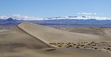
Photograph of Mesquite Flat Dunes in Death Valley looking toward the Cottonwood Mountains from the north west arm of Star Dune (the largest dune in the area — Death Valley National Park, California.
- This photo was taken the morning after a light rain so the dunes were darker than they normally would be.
- Notice the two people standing on the rightmost part of the largest dune in the foreground.
- Photo taken by Daniel Mayer in April 2003.
(c) Tuxyso / Wikimedia Commons, CC BY-SA 3.0
View on Panamint Butt / Panamint Valley from SR190 (at the end of Death Valley) with flash floods and reflections in the water.


