Dartmoor
| Dartmoor | |
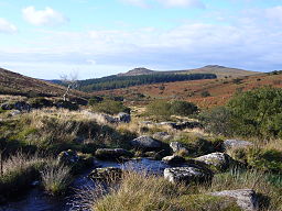
Udsigt langs floden Meavy mod Sharpitor og Leather Tor | |
| Land | |
|---|---|
| Constituent country | |
| County | Devon |
| Højeste punkt | High Willhays[1] |
| - højde | 621 moh |
| Laveste punkt | Doghole Bridge[1] |
| - højde | 24 moh |
| Areal | 954 km² |
| Dyr | Dartmoor-pony |
| Oprettet | 1951 |
| Administration | Dartmoor National Park Authority |
| - Beliggenhed | Bovey Tracey |
| Antal besøgende | 10,98 millioner[2] (1997) |
| IUCN-kategorier | V – Beskyttet landskab/havområde |
Contains Ordnance Survey data © Crown copyright and database right, CC BY-SA 3.0 | |
| Hjemmeside: www.dartmoor-npa.gov.uk | |
Dartmoor er en nationalpark i Devon i England med et areal på 953 km².
Området består af et moselandskab med flere hundrede granittoppe, kendt som tors. Det højeste punkt er High Willhays 621 meter over havets overflade. Der er mange fortidsminder i området blandt andet Grimspound fra bronzealderen og Postbridge fra 1200-tallet.
Dele af Dartmoor har været militær skydebane i mere end 200 år. Resten af nationalparken er åben for offentligheden, og området tiltrækker mange turister.
Dartmoor dannede kulisse om sir Arthur Conan Doyles bog Baskervilles Hund.
Eksterne links
- ^ a b "General Information Factsheet". Dartmoor National Park Authority. Arkiveret fra originalen 8. september 2008. Hentet 12. juli 2009.
- ^ "Sounding Dartmoor: A case study on the soundscapes of rural England at the opening of the 21st Century. John L Drever - Academia.edu". Arkiveret fra originalen 9. oktober 2020. Hentet 6. oktober 2020.
- Dartmoor National Park Authority Arkiveret 2. april 2011 hos Wayback Machine, Nationalparkens hjemmeside
| |||||||||||||||||||||
| Spire Denne artikel om britisk geografi er en spire som bør udbygges. Du er velkommen til at hjælpe Wikipedia ved at udvide den. |
Koordinater: 50°34′N 4°0′V / 50.567°N 4.000°V
|
Medier brugt på denne side
A map of the United Kingdom, overlaid with the UK flag.
Forfatter/Opretter: Own Herby talk thyme, Licens: CC BY-SA 4.0
This cross is known as both Nun's Cross (possibly from the Cornu-Celtic Nans meaning valley or ravine) & Siward's Cross (possibly in connection with Siward, Earl of Nothumberland at the time of Edward the Confessor). It may well be late Saxon or early medieval in origin. It may well have been used as a marker for the track from the monastery at Buckfast to the monastery at Tavistock. It is close to Nun's Cross Farm on South Dartmoor.
Contains Ordnance Survey data © Crown copyright and database right, CC BY-SA 3.0
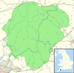
Map of Dartmoor National Park, UK with the following information shown:
- National Park boundary
- Administrative borders
- Coastline, lakes and rivers
- Roads and railways
- Urban areas
Equirectangular map projection on WGS 84 datum, with N/S stretched 150%
Geographic limits:
- West: 4.18W
- East: 3.60W
- North: 50.75N
- South: 50.37N
Forfatter/Opretter: w:User:StephenDawson, Licens: CC BY-SA 2.0
High Willhays, the highest point on Dartmoor and southern England at 621m (2037ft) above sea level, with Yes Tor beyond.
Forfatter/Opretter: Myself - Herby talk thyme, Licens: CC BY-SA 4.0
View towards Sharpitor & Leather Tor down the valley of the river Meavy. The river Meavy is in the foregound. The forestry plantation is just above Burrator reservoir.


