County Laois
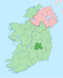
County Laois (irsk: Contae Laoise) er et county i Republikken Irland, hvor det ligger i provinsen Leinster.
County Laois omfatter et areal på 1.719 km² med en samlet befolkning på 69.012 (2006).
Det administrative county-center ligger i byen Portlaoise.
| Wikimedia Commons har medier relateret til: |
| |||||||||||||||||||||||||
|
| Spire |
Koordinater: 53°00′N 7°24′V / 53°N 7.4°V
Medier brugt på denne side
Forfatter/Opretter: Caomhan27, Licens: CC BY-SA 3.0
Flag of Ulster (heraldic banner of traditional coat of arms of the province, not to be confused with the former flag of Northern Ireland).
Forfatter/Opretter:
- Island_of_Ireland_location_map.svg: *Ireland_location_map.svg: NordNordWest
- Northern_Ireland_location_map.svg: NordNordWest
- Northern_Ireland_-_Counties.png: Maximilian Dörrbecker (Chumwa)
- derivative work: Rannpháirtí anaithnid (talk)
- derivative work: Mabuska (talk)
The island of Ireland, showing international border between Ireland and Northern Ireland, traditional provinces, traditional counties, and local authority areas in Ireland and Northern Ireland.
Forfatter/Opretter: CeltBrowne, Licens: CC BY-SA 4.0
The coat of arms of County Laois in the Republic of Ireland, as derived from the official blazon: Or on a chevron gules between in chief two fountains and in base a lion rampant sable seven ermine spots argent, with the motto: I bpáirt leis an bpobal (In partnership with the community).
Forfatter/Opretter:
- Population_density_of_Ireland_map2002.svg: *Ireland_complete.svg: Future Perfect at Sunrise
- derivative work: The Illusional Ministry (talk)
- derivative work: Sswonk (talk)
Map of Ireland's counties with names, Northern Ireland counties colored tan
Map of Ireland with flag.
Forfatter/Opretter: First author Caomhan27, Licens: CC BY-SA 3.0
Flag of w:Connacht.


