Col du Grand Cucheron
| Col du Grand Cucheron | |
|---|---|
.JPG) | |
| Højde | 1.188 m.o.h.[1] |
| Krydses af | Fransk landevej D207 |
| Sted | Savoie-departementet |
| Kæde | Dauphiné-Alperne |
| Koordinater | 45°29′24″N 6°14′53″Ø / 45.49000°N 6.24806°ØKoordinater: 45°29′24″N 6°14′53″Ø / 45.49000°N 6.24806°Ø |
 Col du Grand Cucheron | |

Col du Grand Cucheron
Col du Grand Cucherons beliggenhed i Savoie

Col du Grand Cucheron (1.188 m.o.h.) er et bjergpas i Frankrig. Det ligger i departementet Savoie og krydses af landevejen D207.[2] Det forbinder Maurienne-dalen med Grésivaudan-dalen. Passet ligger i Belledonne-massivet og er en del af Dauphiné-Alperne.
Galleri
 (c) Matthieu Riegler, CC-by
 (c) žába, CC BY 3.0
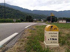
Første skilt med stigningens data set fra Maurienne-dalen

Sidste skilt med stigningens data set fra Maurienne-dalen
Kildehenvisninger
- ^ "maurienne-tourisme.com, grand-cucheron". Hentet 25. maj 2019.
- ^ "Google Maps, Col du Grand Cucheron". Hentet 17. september 2018.
Eksterne henvisninger
| ||||||||||||
| Spire Denne artikel om et fransk naturområde er en spire som bør udbygges. Du er velkommen til at hjælpe Wikipedia ved at udvide den. |
Medier brugt på denne side


France Flag Map.svg
Map showing France with the ch flag.
Map showing France with the ch flag.
Flag map of France.svg
Map showing France with the ch flag.
Map showing France with the ch flag.
Savoie department relief location map.jpg
Forfatter/Opretter: Eric Gaba (Sting - fr:Sting), Licens: CC BY-SA 3.0
Blank physical map of the department of Savoie, France, for geo-location purpose.
Scale : 1:800,000 (precision : 200 m)
Forfatter/Opretter: Eric Gaba (Sting - fr:Sting), Licens: CC BY-SA 3.0
Blank physical map of the department of Savoie, France, for geo-location purpose.
Scale : 1:800,000 (precision : 200 m)
Savoie-Position.svg
Forfatter/Opretter: Marmelad, Licens: CC BY-SA 2.5
Autogenerated image to indicate departement given by filename.
Forfatter/Opretter: Marmelad, Licens: CC BY-SA 2.5
Autogenerated image to indicate departement given by filename.

Col du Grand Cucheron 1 km from top.jpg
Forfatter/Opretter: Jesper Bøtker Mortensen, Licens: CC BY-SA 4.0
Coming up from the Maurienne Valley this is the last signpost of tour climbs
Forfatter/Opretter: Jesper Bøtker Mortensen, Licens: CC BY-SA 4.0
Coming up from the Maurienne Valley this is the last signpost of tour climbs

Col du Grand Cucheron.JPG
(c) Matthieu Riegler, CC-by
Col du Grand Cucheron avec vu au fond sur le massif de la Lozière
(c) Matthieu Riegler, CC-by
Col du Grand Cucheron avec vu au fond sur le massif de la Lozière
Col du Grand Cucheron depuis Col de Champ-Laurent (octobre 2023).JPG
Forfatter/Opretter: Florian Pépellin, Licens: CC BY-SA 4.0
Sight, from Col de Champ-Laurent pass, of Col du Grand Cucheron pass giving on Maurienne valley and Lauzière mountain range, in Savoie, France.
Forfatter/Opretter: Florian Pépellin, Licens: CC BY-SA 4.0
Sight, from Col de Champ-Laurent pass, of Col du Grand Cucheron pass giving on Maurienne valley and Lauzière mountain range, in Savoie, France.


Col du Grand Cucheron 13 km from top.jpg
Forfatter/Opretter: Jesper Bøtker Mortensen, Licens: CC BY-SA 4.0
Coming up from the Maurienne Valley this is the first signpost of tour climbs
Forfatter/Opretter: Jesper Bøtker Mortensen, Licens: CC BY-SA 4.0
Coming up from the Maurienne Valley this is the first signpost of tour climbs
France relief location map.jpg
Forfatter/Opretter: Eric Gaba (Sting - fr:Sting), Licens: CC BY-SA 4.0
Blank physical map of metropolitan France for geo-location purpose.
Scale : 1:14 816 000 (accuracy : about 3,7 km) for the bathymetry. More maps of France, view → Commons Atlas of France.
Forfatter/Opretter: Eric Gaba (Sting - fr:Sting), Licens: CC BY-SA 4.0
Blank physical map of metropolitan France for geo-location purpose.
Scale : 1:14 816 000 (accuracy : about 3,7 km) for the bathymetry. More maps of France, view → Commons Atlas of France.