Christinenthal
| Christinenthal | |
| Våben | Beliggenhed |
 | (c) Karte: NordNordWest, Lizenz: Creative Commons by-sa-3.0 de |
| Administration | |
| Land | |
|---|---|
| Delstat | Slesvig-Holsten |
| Kreis | Steinburg |
| Amt | Schenefeld |
| Borgmester | Claus Peter Ralfs |
| Statistiske data | |
| Areal | 3,37 km² |
| Højde | 15 m |
| Indbyggere | 62 (31/12/2018) |
| - Tæthed | 18 Indb./km² |
| Andre informationer | |
| Tidszone | CET/CEST (UTC+1/UTC+2) |
| Nummerplade | IZ |
| Postnr. | 25593 |
| Tlf.-forvalg | 04892 |
| Koordinater | 54°3′16″N 9°31′59″Ø / 54.05444°N 9.53306°ØKoordinater: 54°3′16″N 9°31′59″Ø / 54.05444°N 9.53306°Ø |
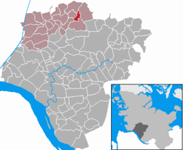
| Beliggenhed af kommunen Christinenthal i Landkreis Steinburg | |
 | |
Christinenthal er en by og kommune i det nordlige Tyskland, beliggende i Amt Schenefeld i den nordvestlige del af Kreis Steinburg. Kreis Steinburg ligger i den sydvestlige del af delstaten Slesvig-Holsten.
Geografi
Christinenthal ligger ved Bundesstraße B430 mellem Schenefeld og Hohenwestedt. Vandløbene Bekau og Lammsbek løber gennem kommunen.
Eksterne kilder/henvisninger
- Kommunens side Arkiveret 16. august 2017 hos Wayback Machine på amtets websted
- Statistikamt Nord – Bevölkerung der Gemeinden in Schleswig-Holstein 4. Quartal 2014 (XLSX-Data) (Fortschreibung auf Basis des Zensus 2011)
Medier brugt på denne side
(c) Karte: NordNordWest, Lizenz: Creative Commons by-sa-3.0 de
Location map of Germany
Forfatter/Opretter: ClausG, Licens: CC BY-SA 3.0
This map shows the area of the municipality Christinenthal in the Kreis (district) Steinburg, Schleswig-Holstein, Germany.
Coat of arms of the municipality Christinenthal in Schleswig-Holstein, Germany.


