Cheshire

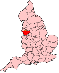
Cheshire er et grevskab i England med Chester som administrationsby. Grevskabet tilhører regionen North West England og grænser op til Merseyside, Stor-Manchester, Derbyshire, Staffordshire og Shropshire samt det walisiske grevskab Clwyd. Pr. 2002 boede der 986.079 indbyggere i grevskabet, som totalt dækker et areal på 2.343 km².
Cheshire er opdelt i fire områder; Cheshire East, Cheshire West and Chester, Halton og Warrington. Den største by er Warrington, mens Chester er county town.
Byer
| # | By | Council area | Indbyggertal[1][2][3][4][5] | ||
|---|---|---|---|---|---|
| 2001 | 2011 | 2021 | |||
| 1 | Warrington | Warrington | 157,860 | 165,456 | 174,954 |
| 2 | Chester | Cheshire West and Chester | 81,650 | 86,011 | 92,742 |
| 3 | Crewe | Cheshire East | 67,760 | 71,722 | 74,123 |
| 4 | Runcorn | Halton | 60,320 | 61,789 | 61,635 |
| 5 | Widnes | Halton | 55,680 | 61,464 | 59,939 |
| 6 | Ellesmere Port | Cheshire West and Chester | 62,510 | 61,090 | 65,421 |
| 7 | Macclesfield | Cheshire East | 54,440 | 56,581 | 54,340 |
| 8 | Northwich | Cheshire West and Chester | 42,820 | 45,471 | 50,531 |
| 9 | Winsford | Cheshire West and Chester | 29,440 | 30,259 | 35,000 |
| 10 | Wilmslow | Cheshire East | 34,090 | 35,945 | 26,000 |
| 11 | Congleton | Cheshire East | 25,510 | 26,178 | |
| 12 | Sandbach | Cheshire East | 17,630 | 17,976 | |
| 13 | Nantwich | Cheshire East | 13,450 | 17,226 | |
| 14 | Poynton | Cheshire East | 15,442 | 15,282 | |
| 15 | Neston | Cheshire West and Chester | 15,018 | 15,064 | |
| 16 | Middlewich | Cheshire East | 13,100 | 13,595 | |
| 17 | Alsager | Cheshire East | 14,178 | 13,347 | |
| 18 | Knutsford | Cheshire East | 12,656 | 13,191 | |
| 19 | Lymm | Warrington | 9,830 | 11,608 | |
| 20 | Frodsham | Cheshire West and Chester | 8,908 | 9,032 | |
| 21 | Bollington | Cheshire East | 6,880 | 7,373 | |
| 22 | Culcheth | Warrington | 6,730 | 6,708 | |
| 23 | Weaverham | Cheshire West and Chester | 6,293 | 6,087 | |
| 24 | Holmes Chapel | Cheshire East | 5,669 | 5,605 | |
| 25 | Helsby | Cheshire West and Chester | 4,911 | 5,166 | |
| 26 | Haslington | Cheshire East | 5,075 | 4,855 | |
Se også
Referencer
- ^ "Warrington (Unitary District, North West England, United Kingdom) – Population Statistics, Charts, Map and Location". www.citypopulation.de (engelsk).
- ^ "Cheshire West and Chester (Unitary District, North West England, United Kingdom) – Population Statistics, Charts, Map and Location". www.citypopulation.de (engelsk).
- ^ "Cheshire East (Unitary District, North West England, United Kingdom) – Population Statistics, Charts, Map and Location". www.citypopulation.de (engelsk).
- ^ "Halton (Unitary District, North West England, United Kingdom) – Population Statistics, Charts, Map and Location". www.citypopulation.de (engelsk).
- ^ 2011 census table: ONS
 | Wikimedia Commons har medier relateret til: |
53°10′00″N 2°35′00″V / 53.166666666667°N 2.5833333333333°V

