Campolongopasset
| Campolongopasset | |
|---|---|
| Passo Campolongo Campolongo Pass | |
 | |
| Højde | 1.875 m.o.h.[1] |
| Længde | 10 km[2][3] |
| Krydses af | Italienske landevej SP244[4] |
| Sted | |
| Kæde | Alperne |
| Koordinater | 46°31′12″N 11°52′27″Ø / 46.52000°N 11.87417°ØKoordinater: 46°31′12″N 11°52′27″Ø / 46.52000°N 11.87417°Ø |
 Campolongopasset | |
Campolongopasset (1.875 m.o.h.) (italiensk: Passo Campolongo) er et bjergpas i de italienske alper, som forbinder Arabba med Alta Badia.[5]
Landevejen over passet forbinder byerne Corvarra og Arabba. Vejen over passet blev bygget mellem 1889 og 1901.[6]
Vejpasset ligger i den såkaldte Sellagruppe. Passet er en del af Sellaronda, som er en berømt turistvej.[7][8] Heri indgår også Sellapasset, Gardenapasset og Pordoipasset.[9]
Galleri

Vinter på Campolongo til højre i billedet


Vejskilt - Passo Campolongo
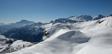
Snedække på Campolongo til venstre i billedet
Kildehenvisninger
- ^ "dolomiti.org, sellaronda-in-moto". Arkiveret fra originalen 28. maj 2019. Hentet 28. maj 2019.
- ^ "paesseatlas.de, Passo Campolongo". Hentet 28. maj 2019.
- ^ "Google Maps, Arabba - Corvarra". Hentet 28. maj 2019.
- ^ "Google Maps, Passo Campolongo". Hentet 28. maj 2019.
- ^ "arabba.it, Passo Campolongo". Hentet 28. maj 2019.
- ^ "sentres.com, Passo Campolongo". Hentet 28. maj 2019.
- ^ "telegraph.co.uk, sella-ronda-bike-ride". Hentet 28. maj 2019.
- ^ "paesseatlas.de, sellajoch". Hentet 28. maj 2019.
- ^ "dolomiti.org, sellaronda". Arkiveret fra originalen 28. maj 2019. Hentet 28. maj 2019.
Eksterne henvisninger
|
Medier brugt på denne side

Campolongo0001.jpg
Forfatter/Opretter: No machine-readable author provided. Idéfix~commonswiki assumed (based on copyright claims)., Licens: CC BY-SA 3.0
Forfatter/Opretter: No machine-readable author provided. Idéfix~commonswiki assumed (based on copyright claims)., Licens: CC BY-SA 3.0
Passo Campolongo
Picture taken by user Idéfix , november 1, 2006
Cherz y Pas Ciaulong.jpg
Forfatter/Opretter:
,
Licens: CC BY-SA 3.0
Skiing on the "Cherz" area in Alta Badia, Dolomites - South Tyrol - on the right pass Campolongo
Forfatter/Opretter:
| Feel free to use my photos, but please mention me as the author and send me a message. |
This image is not in the public domain. Please respect the copyright protection. It may only be used according to the rules mentioned here. This specifically excludes use in social media, if applicable terms of the licenses listed here not appropriate.
|

| Please do not upload an updated image here without consultation with the Author. The author would like to make corrections only at his own source. This ensures that the changes are preserved.
Please if you think that any changes should be required, please inform the author. Otherwise you can upload a new image with a new name. Please use one of the templates derivative or extract. |
Skiing on the "Cherz" area in Alta Badia, Dolomites - South Tyrol - on the right pass Campolongo

Col de Stagn y pas Ciaulong.JPG
Forfatter/Opretter:
,
Licens: CC BY-SA 3.0
Skiing at the "Col de Stagn" in the Sella Group, Dolomites - South Tyrol - on the left pass Campolongo
Forfatter/Opretter:
| Feel free to use my photos, but please mention me as the author and send me a message. |
This image is not in the public domain. Please respect the copyright protection. It may only be used according to the rules mentioned here. This specifically excludes use in social media, if applicable terms of the licenses listed here not appropriate.
|
|
| Please do not upload an updated image here without consultation with the Author. The author would like to make corrections only at his own source. This ensures that the changes are preserved.
Please if you think that any changes should be required, please inform the author. Otherwise you can upload a new image with a new name. Please use one of the templates derivative or extract. |
Skiing at the "Col de Stagn" in the Sella Group, Dolomites - South Tyrol - on the left pass Campolongo

Campolongo0002.jpg
Forfatter/Opretter: No machine-readable author provided. Idéfix~commonswiki assumed (based on copyright claims)., Licens: CC BY-SA 3.0
Forfatter/Opretter: No machine-readable author provided. Idéfix~commonswiki assumed (based on copyright claims)., Licens: CC BY-SA 3.0
Passo Campolongo
Picture taken by user Idéfix , november 1, 2006
Campolongo0.jpg
Forfatter/Opretter: No machine-readable author provided. Idéfix~commonswiki assumed (based on copyright claims)., Licens: CC BY-SA 3.0
Forfatter/Opretter: No machine-readable author provided. Idéfix~commonswiki assumed (based on copyright claims)., Licens: CC BY-SA 3.0
Passo Campolongo
Picture taken by user Idéfix 2001