Bumba
| Bumba Bumba | |
|---|---|
 | |
| Overblik | |
| Land | |
| provinser i Demokratiske Republik Congo | Bumba |
| UN/LOCODE | CDBMB |
| Demografi | |
| Indbyggere | 103.328 (2010) |
| Andet | |
| Tidszone | UTC+1 |
| Højde m.o.h. | 409 m |
| Oversigtskort | |
(c) Karte: NordNordWest, Lizenz: Creative Commons by-sa-3.0 de Bumba | |

Bumba er en by og flodhavn der ligger ved breden af Congofloden i Mongala-provinsen i Demokratiske Republik Congo. Den er det det administrative centrum for Bumba-territoriet. I 2010 havde den en anslået samlet befolkning på 103.328 mennesker.[1] Byen har hverken elektricitet eller rindende vand.[2]
Infrastruktur
Fra 2007 er den smalsporede jernbane, Vicicongo-linjen fra Bumba til Isiro ikke i drift. Byen kan nås via Bumba Lufthavn, men Congofloden er hovedtransportpulsåren.
Referencer
- ^ "Congo (Dem. Rep.): largest cities and towns and statistics of their population". World Gazetteer. Hentet 21. januar 2009. (Webside ikke længere tilgængelig)
- ^ Poon, Linda (3. maj 2015). "What Happens To A Country When An Outbreak Of Ebola Ends?". NPR. Hentet 4. maj 2015.
| Spire |
Medier brugt på denne side
The national flag of the Democratic Republic of the Congo. Created according to the 2006 constitution : Son emblème est le drapeau bleu ciel, orné d’une étoile jaune dans le coin supérieur gauche et traversé en biais d’une bande rouge finement encadrée de jaune. (Its symbol is a sky blue flag, decorated with a yellow star in the upper left corner and crossed in the diagonal by a red strip with thin yellow borders) It seems to be identical, except for a lighter field hue, to the 1966–1971 flag.
(c) Karte: NordNordWest, Lizenz: Creative Commons by-sa-3.0 de
Location map of the Democratic Republic of the Congo
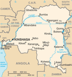
Democratic Republic of the Congo map from CIA World Factbook, converted from original GIF format (July 2011 version showing South Sudan)
The Station at Bumba - p. 426


