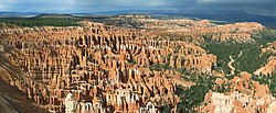
Bryce Canyon National Park
Bryce Canyon National Park er en nationalpark i den sydvestlige Utah i USA. Inden for parkens område ligger Bryce Canyon, som er et stort, "amfiteater" dannet ved erosion langs den østlige side af Paunsaugunt plateauet.
Nationalparken ligger i omkring 2.500 meters høje over havet og omfatter ca. 145 km²
De første hvide nybyggere, der slog sig ned i området omkring 1850 var mormoner. I 1875 slog Ebenezer Bryce sig ned i området, og efter ham har kløften fået sit navn.
Nationalparken ligger ret afsides, og har derfor forholdsvis få besøgende. Godt 800.000 (2006) mod de over 4 millioner, der besøger Grand Canyon National Park og 2.5 millioner, der besøger den nærliggende Zion National Park.
Eksterne kilder/henvisninger
| Spire |
|
Koordinater: 37°37′42″N 112°10′05″V / 37.6283°N 112.168°V
Medier brugt på denne side
(c) Lokal_Profil, CC BY-SA 2.5
Map showing Mainland USA ("lower 48") with a superimposed US flag.
Logo of the United States National Park Service, an agency of the United States Department of the Interior. This version is shaded to look as if it has been carved out of wood or rock. The elements on the logo represent the major facets of the national park system. The Sequoia tree and bison represent vegetation and wildlife, the mountains and water represent scenic and recreational values, and the arrowhead represents historical and archeological values. The bison is also the symbol of the Department of the Interior. The logo became the official logo on July 20, 1951, replacing the previous emblem of a Sequoia cone, and has been used ever since. The design was slightly updated in 2001, and a few different renderings are used today. For more information, see here and here.[dead link]
(c) I, Jonathan Zander, CC BY-SA 3.0
Panorama of Hoodoos in Bryce Canyon National Park, Utah. This version has improved contrast and is downsampled. Take with a Canon PowerShot S400 Camera


