Bourscheid
| |||
| Placering | |||
|---|---|---|---|
 | |||
| Information | |||
| Land | |||
| Distrikt (Mørkegrå) | Diekirch | ||
| Kanton (Mørkerød) | Diekirch | ||
| Areal | 36,86 km² | ||
| Befolkning - Total | (2005) 1.231 indbyggere | ||
Bourscheid (luxembourgsk: Buerschent, tysk: Burscheid) er en kommune og et byområde i Luxembourg. Kommunen, som har et areal på 36,86 km², ligger i kantonen Diekirch i distriktet Diekirch. I 2005 havde kommunen 1.231 indbyggere.
Galleri
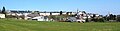
Udsigt over byen

Bourscheid Slot
Eksterne henvisninger
| ||||||||

| Spire Denne artikel om luxembourgsk geografi er en spire som bør udbygges. Du er velkommen til at hjælpe Wikipedia ved at udvide den. |
Koordinater: 49°54′33″N 6°03′46″Ø / 49.909167°N 6.062778°Ø
|
Medier brugt på denne side


Luxembourg geo stub.svg
Forfatter/Opretter: Escondites, Licens: CC BY-SA 4.0
An SVG map for the Luxembourg geo stub template on en-wiki
Forfatter/Opretter: Escondites, Licens: CC BY-SA 4.0
An SVG map for the Luxembourg geo stub template on en-wiki

NW Bastion Bourscheid.JPG
Forfatter/Opretter: Caranorn, Licens: CC BY-SA 4.0
North-West Bastion (built after 1477) and approach to the gates of Castle Bourscheid. Also visible (to the right) two towers of the South-Western lower-Bailey (built in the 14th century), the roof of the main gatehouse (centre) and the Bergfried (left).

Coat of arms bourscheid luxbrg.png
Forfatter/Opretter: Spanish Inquisition, Licens: CC BY-SA 3.0
Coat of arms of the municipality of Bourscheid, Luxembourg
Forfatter/Opretter: Spanish Inquisition, Licens: CC BY-SA 3.0
Coat of arms of the municipality of Bourscheid, Luxembourg

Buerschent.jpg
Forfatter/Opretter: Les Meloures, Licens: CC BY-SA 2.5
Village of Bourscheid seen from the hill Béchel.
Forfatter/Opretter: Les Meloures, Licens: CC BY-SA 2.5
Village of Bourscheid seen from the hill Béchel.