Bosporus


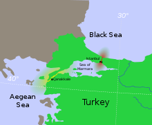
Bosporus eller Bosporusstrædet (tyrkisk İstanbul Boğazı) er det stræde, som skiller Europa og Lilleasien fra hinanden. Strædet er 30 km langt og mellem 750 m og 3,7 km bredt. Strædet skærer midt igennem Istanbul, og deler dermed byen i en europæisk og en asiatisk del.
Bosporus forbinder Sortehavet med Marmarahavet. Fra Marmarahavet er gennem Dardanellerne vandforbindelse til Ægæerhavet og derigennem til Middelhavet.
Bugten Det Gyldne Horn, der nord for Istanbuls historiske kerne skærer sig ind i Bosporus' europæiske bred, er en naturlig havn.
41°9′N 29°4′Ø / 41.150°N 29.067°Ø
| Spire |
Medier brugt på denne side
Forfatter/Opretter: User:Interiot, Licens: CC BY-SA 2.5
Disambiguation for Turkish Straits.
Istanbul, Turkey: The Crossroads of Europe and Asia
This digital camera image was taken by the crew of the International Space Station on April 16, 2004. When this image was taken, strong currents carried turbid coastal waters from the Black Sea through the Strait and into the Sea of Marmara. The rugged uplands to the north of the city are forested and contain vital reservoirs. Note Ataturk airport southwest of the city near the bottom of the image, the picturesque Prince Islands in the Sea of Marmara, and the sinuous waterway and harbor on the western shore known as the Golden Horn.
Astronaut photograph ISS008-E-21752 was taken with a Kodak DCS760 digital camera equipped with an 200-mm lens, and is provided by the Earth Observations Laboratory, Johnson Space Center. The International Space Station Program supports the laboratory to help astronauts take pictures of Earth that will be of the greatest value to scientists and the public, and to make those images freely available on the Internet. Additional images taken by astronauts and cosmonauts can be viewed at the NASA/JSC Gateway to Astronaut Photography of Earth.


