Blaenau Gwent
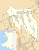
Blaenau Gwent et county borough i det sydvestlige Wales. Det grænser op til Monmouthshire og Torfaen mod øst, Caerphilly mod vest og Powys mod nord. De største byer er Abertillery, Brynmawr, Ebbw Vale og Tredegar. Det højeste punkt er Coity Mountain med 578 moh.
I 2017 havde countiet 70.020 indbyggere. Ifølge en folketælling fra 2011 kan 5,5% af countiets befolkning (ca. 3.705 personer) tale, læse og skrive walisisk,[1] mens 7,8%, eller 5.284 beboere blot kan tale walisisk.[2] Ved samme folketælling havde Blaenau Gwent det højeste niveau af fattigdom blandt børn i Wales.[3]
Referencer
- ^ Welsh language skills by electoral division, 2011 Census Retrieved 13/12/21
- ^ Welsh speakers by local authority, gender and detailed age groups, 2011 census Retrieved 13/12/21
- ^ "Save the Children: Severe child poverty Wales highest". BBC News. 23. februar 2011. Hentet 20. august 2017.
51°46′33″N 3°11′47″V / 51.775833333333°N 3.1963888888889°V
Medier brugt på denne side
Contains Ordnance Survey data © Crown copyright and database right, CC BY-SA 3.0
Blank map of Blaenau Gwent, UK with the following information shown:
- Administrative borders
- Coastline, lakes and rivers
- Roads and railways
- Urban areas
Equirectangular map projection on WGS 84 datum, with N/S stretched 160%
Geographic limits:
- West: 3.35W
- East: 3.10W
- North: 51.85N
- South: 51.65N


