Aruba
Aruba Aruba | |
|---|---|
 Våbenskjold | |
Nationalmelodi: Aruba Dushi Tera | |
 Arubas beliggenhed i Caribien | |
 Kort over Aruba | |
| Hovedstad og største by | Oranjestad 12°31′N 70°02′V / 12.517°N 70.033°V |
| Officielle sprog | Nederlandsk; Papiamento[1] |
| Regeringsform | Konstitutionelt monarki |
• Konge | Willem-Alexander |
• Guvernør | Alfonso Boekhoudt |
• Premierminister | Evelyn Wever-Croes |
| Lovgivende forsamling | Staterne |
| Befolkning | |
• Anslået 2024 | |
• Tæthed | 600/km2 |
| ISO 3166-kode | AW, ABW, 533 |
Aruba er en ø i det sydlige Caribien og et af de fire konstituerende lande, der udgør Kongeriget Nederlandene (udover Curaçao, Nederlandene og Sint Maarten). Indbyggerne i Aruba er derfor også nederlandske statsborgere.
Arubas hovedstad er Oranjenstad.
Historie
Aruba var først beboet af indianere, den tidligst kendte bosættelse er dateret til 1000-tallet. I 1499 blev øen opdaget af spanieren Alonso de Ojeda, og tilhørte Spanien frem til 1636, hvor den blev hollandsk. Fra 1845 til 1986 tilhørte Aruba de Nederlandske Antiller, men siden 1986 har Aruba været adskilt fra de Nederlandske Antiller.
De Nederlandske Antiller ophørte d. 10. oktober 2010 med at eksistere som en administrativ enhed. Øerne fik fra denne dato ny status indenfor Nederlandene: Bonaire, Sint Eustatius og Saba er herefter en direkte del af Nederlandene som særlige kommuner, og Curaçao og Sint Maarten har nu status som selvstændige lande indenfor Kongeriget Nederlandene – samme status som Aruba fik i 1986.[3]
Geografi
Øen ligger 45 kilometer fra Venezuelas kyst.
Politik
Staterne er Arubas lovgivende forsamling.
Galleri

 (c) Em erasmus, CC BY-SA 3.0Imeldahof, et krisecenter for børn i Noord, der har eksisteret siden 1970'erne. Bygget i 1950'erne.
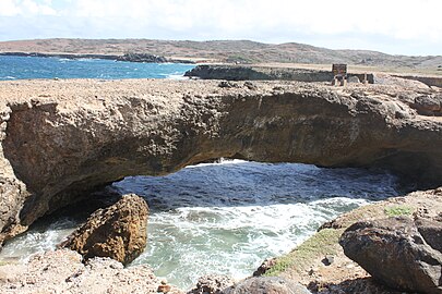 Naturlig klippebro.
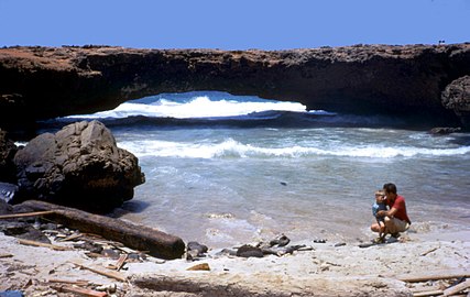 Klippebro der kollapsede i 1973. Fotograferet i 1973.
 Parlamentet
.jpg)
Kilde
- ^ Migge, Bettina; Léglise, Isabelle; Bartens, Angela (2010). Creoles in Education: An Appraisal of Current Programs and Projects. Amsterdam: John Benjamins Publishing Company. s. 268. ISBN 978-90-272-5258-6. Arkiveret fra originalen 3. maj 2016. Hentet 7. maj 2016.
- ^ Skabelon:Https://www.worldometers.info/world-population/population-by-country/
- ^ "avisartikel". Arkiveret fra originalen 12. juni 2011. Hentet 22. januar 2011.
Eksterne henvisninger
| Wikimedia Commons har medier relateret til: |
| Spire Denne artikel om nederlandsk geografi er en spire som bør udbygges. Du er velkommen til at hjælpe Wikipedia ved at udvide den. |
Medier brugt på denne side

The flag of Aruba

The Flag of Europe is the flag and emblem of the European Union (EU) and Council of Europe (CoE). It consists of a circle of 12 golden (yellow) stars on a blue background. It was created in 1955 by the CoE and adopted by the EU, then the European Communities, in the 1980s.
The CoE and EU are distinct in membership and nature. The CoE is a 47-member international organisation dealing with human rights and rule of law, while the EU is a quasi-federal union of 27 states focused on economic integration and political cooperation. Today, the flag is mostly associated with the latter.
It was the intention of the CoE that the flag should come to represent Europe as a whole, and since its adoption the membership of the CoE covers nearly the entire continent. This is why the EU adopted the same flag. The flag has been used to represent Europe in sporting events and as a pro-democracy banner outside the Union.

.svg)

Forfatter/Opretter: Versageek, Licens: CC BY 3.0
Natural Bridge in Aruba - circa June 1973. This is the larger of the two bridges. It collapsed in 2005.

(c) Em erasmus, CC BY-SA 3.0
This is a photo of a monument in Aruba identified by the ID

Map of the Netherlands with flag.

Forfatter/Opretter: PrasadGondi, Licens: CC BY-SA 3.0
Natural bridge in Aruba

Forfatter/Opretter: David et Magalie fra Vancouver, Canada, Licens: CC BY 2.0
typical dutch architecture. pretty nice considering that the guidebook said that there was nothing to see in Aruba, architecture-wise, that is...
oranjestad
Forfatter/Opretter: TUBS
Location of XY (see filename) in the region.