Anhalt-Köthen
Fyrstendømmet Anhalt-Köthen Fürstentum Anhalt-Köthen | |
|---|---|
| Territorium i Det Tysk-Romerske Rige {1832-1509, 1606-1806) Medlem af Rhinforbundet (1806-1813) Medlem af Tyske Forbund (1815-1847) | |
| 1382–1847 | |
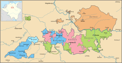
 De anhaltske fyrstendømmer i anden halvdel af 1700-tallet. | |
| Regeringsform | Monarki |
| Historie | |
• Etableret | 1382 |
• Ophørt | 1847 |
Anhalt-Köthen var et fyrstedømme og fra 1806 et hertugdømme) i det centrale Tyskland som existerede under dette navn fra 1382–1847, med en pause 1552 til 1603, hvor fyrstedømmet var en del af Anhalt-Dessau. Hovedstaden var Köthen. Fra 1847 til 1863 hørte det under Anhalt-Bernburg og blev så en del af hertugdømmet Anhalt . Anhalt-Köthen indgik i det Tyske rige i 1918. Anhalt-Köthen er i dag en del af delstaten Sachsen-Anhalt.
Fyrster af Anhalt-Köthen 1396–1561
Til Anhalt-Dessau 1552.
Fyrster af Anhalt-Köthen 1603–1807
- Ludvig 1. 1603–49
- Vilhelm Ludvig 1649–65
- Lebrecht 1665–69
- Emmanuel 1669–70
- Emmanuel Leberecht 1671–1704
- Leopold 1704–28
- August Ludvig 1728–55
- Karl Georg Lebrecht 1755–89
- August Christian Frederik 1789–07
Hertugdømme fra 1807.
Hertuger af Anhalt-Köthen 1807-1847
Til Anhalt-Dessau 1847.
| |||||||||||||||||||||||||
| |||||||||||||||||||||||||||||||||||||
| Spire |
Koordinater: 51°45′00″N 11°58′00″Ø / 51.75°N 11.966667°Ø
|
Medier brugt på denne side
is almost identical to that of 1. Versailles version but signed
Forfatter/Opretter: ziegelbrenner, Licens: CC BY 2.5
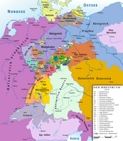
Map of Confederation of the Rhine 1812
Forfatter/Opretter: ziegelbrenner, Licens: CC BY 2.5
Map of German Confederation 1815–1866
Forfatter/Opretter: Vektorgrafikken blev lavet med Inkscape. ., Licens: CC BY-SA 3.0
Imperial Coat of arms of the German Empire, as proposed in 1848.
Flag of Anhalt-Bernburg (1830-1863), Anhalt-Köthen (1813-1847), and Anhalt-Dessau (1813-18??)
Forfatter/Opretter: Sir Iain, Licens: CC BY-SA 3.0
Map of Anhalt between 1747 and 1793, between the purchase of the Amt Alsleben by Anhalt-Dessau and the extinction of the House of Anhalt-Zerbst.


