Anhalt-Dessau
Fyrstendømmet Anhalt-Dessau Fürstentum Anhalt-Dessau | |
|---|---|
| Fyrstendømme under Det tysk-romerske Rige | |
| 1396–1863 | |
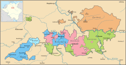
 Kort over Anhalt i perioden 1747-1793 mellem sammenlægningen med Amt Alsleben til Anhalt-Dessau og ophøret af Huset Anhalt-Zerbst. | |
| Hovedstad | Dessau |
| Regeringsform | Monarki |
| Fyrste Hertug | |
• 1396–1405 | Sigismund 1. |
• 1817–1863 | Leopold 4. |
| Historie | |
• Etableret | 1396 |
• Ophørt | 1863 |
Anhalt-Dessau var et fyrstendømme i det Tysk-romerske rige, og senere et hertugdømme i det Det tyske forbund. Det tilhørte Huset Askanien, og blev oprettet i 1396 efter opdelingen af Fyrstendømmet Anhalt-Zerbst, og endeligt lagt ind i Hertugdømmet Anhalt i 1863. Hovedstaden var Dessau i det nuværende Sachsen-Anhalt.
| |||||||||||||||||||||||||
| |||||||||||||||||||||||||||||||||||||
| Spire |
|
Koordinater: 51°49′17″N 12°14′32″Ø / 51.8214°N 12.2423°Ø
Medier brugt på denne side
Flag map of Germany
Forfatter/Opretter: ziegelbrenner, Licens: CC BY 2.5
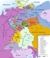
Map of Confederation of the Rhine 1812
Forfatter/Opretter: Berthold Werner, Licens: CC BY-SA 3.0
Berlin, Brandenburg Gate, eastside
Forfatter/Opretter: ziegelbrenner, Licens: CC BY 2.5
Map of German Confederation 1815–1866
Forfatter/Opretter: Glasshouse with elements by Sodacan, Licens: CC BY-SA 4.0
Shield of the Duchy of Anhalt
Forfatter/Opretter: Vektorgrafikken blev lavet med Inkscape. ., Licens: CC BY-SA 3.0
Imperial Coat of arms of the German Empire, as proposed in 1848.
Flag of Anhalt-Bernburg (1830-1863), Anhalt-Köthen (1813-1847), and Anhalt-Dessau (1813-18??)
Forfatter/Opretter: Sir Iain, Licens: CC BY-SA 3.0
Map of Anhalt between 1747 and 1793, between the purchase of the Amt Alsleben by Anhalt-Dessau and the extinction of the House of Anhalt-Zerbst.


