Achæmenidiske rige
Achæmenidiske rige امپراتوری هخامنشی Emperâturi-ye Hakhâmaneshi | |||||||||||||||
|---|---|---|---|---|---|---|---|---|---|---|---|---|---|---|---|
| Imperium | |||||||||||||||
| 550 f.Kr.–330 f.Kr. | |||||||||||||||
Standard af Kyros den Store | |||||||||||||||
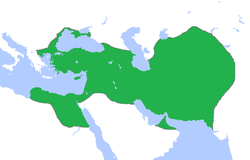
 Det Achaemenidiske rige i 480 f.Kr. | |||||||||||||||
| Hovedstad | Pasargadae, Ecbatana, Persepolis, Susa, Babylon | ||||||||||||||
| Sprog | Oldpersisk, Aramaeisk, Elamitisk, Akkadisk | ||||||||||||||
| Religion | Zarathustrianisme | ||||||||||||||
| Regeringsform | Feudale Monarki | ||||||||||||||
| Shahanshah (Kongernes konge) | |||||||||||||||
• 559-530 f.kr. | Kyros den Store (første) | ||||||||||||||
• | Dareios 3. (sidste) | ||||||||||||||
| Historie | |||||||||||||||
• Persisk oprør | 550 f.Kr. | ||||||||||||||
• Slaget ved Pelusium | 525 f.Kr. | ||||||||||||||
• Perserkrigene | 498–448 f.Kr. | ||||||||||||||
• Fald til Makedonien | 330 f.Kr. | ||||||||||||||
| Areal | |||||||||||||||
• | ca 8 mio km² | ||||||||||||||
| |||||||||||||||
Det Achæmenidiske rige (550-330 f.Kr.) var det første persiske rige[1]. Det blev grundlagt af Kyros den Store i 550 f.Kr. efter han besejrede Lydien og Det nybabylonske kaldæiske rige. Riget er opkaldt efter den mytiske kong Achaimenes, der regerede Persien fra 705 f.Kr. til 675 f.Kr. Fra den iranske højslette beherskede achæmeniderne et vidtstrakt område, der omfattede mange vasalstater i de kaukasiske bjergegne, Centralasien, Mellemøsten og den sydlige del af Balkan, hvor nutidens Grækenland, Makedonien, Egypten, Jordan, Israel, Libanon, Syrien, Tyrkiet, Iran, Irak, Pakistan og Armenien ligger.
Omkring 600'erne f.Kr. havde perserne (Parsa) bosat sig i det sydvestlige område Parsua (Persis på græsk)[2] af den iranske højslette. Området var afgrænset mod vest af floden Tigris og mod syd af den Persiske Bugt. Dette område blev den centrale del af det Achæmenidiske rige. Herfra udgik Kyros den Stores hær, der besejrede Mederne, Lydien og Det nybabylonske kaldæiske rige. Disse sejre banede vejen for den efterfølgende erobring af Egypten.
Riget havde en god central administration, der blev styret gennem vasaller, som alle talte samme sprog. Der blev etableret postvæsen samt gode vejforbindelser. [3] Alexander den Store, der var en stor beundrer af Kyros den Store, erobrede størstedelen af riget 330 f.Kr.[4]
Referencer
- ^ Sampson, Gareth C. (2008). The Defeat of Rome: Crassus, Carrhae and the Invasion of the East. Pen & Sword Books Limited. s. 33. ISBN 978-1-84415-676-4.
Kyros den Store, grundlægger af det første persiske rige (c. 550–330 BC).
- ^ http://www.utexas.edu/cola/centers/lrc/eieol/opeol-MG-X.html Arkiveret 18. februar 2016 hos Wayback Machine Macdonell and Keith, Vedic Index. This is based on the evidence of an Assyrian inscription of 844 BC referring to the Persians as Paršu, and the Behistun Inscription of Darius I referring to Parsa as the area of the Persians. Radhakumud Mookerji (1988). Chandragupta Maurya and His Times (p. 23). Motilal Banarsidass Publ. ISBN 81-208-0405-8.
- ^ Ulrich Wilcken (1967). Alexander the Great. W. W. Norton & Company. s. 146. ISBN 978-0-393-00381-9.
- ^ Taagepera, Rein (1979). "Size and Duration of Empires: Growth-Decline Curves, 600 B.C. to 600 A.D.". Social Science History. 3 (3/4): 123. doi:10.2307/1170959. JSTOR 1170959.
A superimposition of the maps of Achaemenid and Alexander's empires shows a 90% match, except that Alexander's realm never reached the peak size of the Achaemenid realm.
Eksterne links
| ||||||||||||||||||||||||||||||||||||||
| Spire |
| Spire |
| Spire |
Koordinater: 32°32′11″N 44°25′15″Ø / 32.53639°N 44.42083°Ø
|
Medier brugt på denne side
Forfatter/Opretter: Crates, Licens: CC BY-SA 4.0
Map of the Median Empire since 600 B. C.
Reconstruction of the Achaemenid "falcon standard", based on the design of a tile of Egyptian blue frit found at Persepolis in 1948 (Īrān-Bāstān Museum, Tehran, no. 2436), with the addition of coloring.
The plaque shows Egyptian Horus, but in the Persian context was likely associated with the Avestan "glory-bringing bird", varəγna.
Literature: Sāmī, Persepolis, tr. R. Sharp, Shiraz, 1970, fig. facing p. 100; H. Luschey, "Ein königliches Emblem," AMI 5, 1972, pp. 257-60. A. Shapur Shahbazi, DERAFŠ, Encylopedia Iranica (1994).
- The standard is described by Xenophon in Cyropaedia (Book VII, C.1) as: "...and the word went down the lines, "Eyes on the standard and steady marching!". The standard was a golden eagle, with outspread wings, borne aloft on a long spear-shaft, and to this day such is the standard of the Persian king." (however here he is describing Artaxerxes II's standard at Cunaxa).
is almost identical to that of 1. Versailles version but signed
Forfatter/Opretter: Jeff Dahl, Licens: CC BY-SA 4.0
Map of Ancient Egypt, showing the Nile up to the fifth cataract, and major cities and sites of the Dynastic period (c. 3150 BC to 30 BC). Cairo and Jerusalem are shown as reference cities.
Map of the Neo-Babylonian Empire.
Forfatter/Opretter: Gabagool, Licens: CC BY 3.0
This a map of the Achaemenid Empire showing its greatest extent. I have given it more regions as listed on the Behistun Inscription the Persian King Darius wrote telling his conquests.
Forfatter/Opretter: self, based on WP locator maps Category:Locator maps, Licens: CC BY-SA 3.0
Lydian Empire ca. 600 BCE.


