Šolta
| Šolta | |
|---|---|
 Uvala Jorja | |
| Geografi | |
 Šolta | |
| Sted | Adriaterhavet |
| Koordinater | 43°23′01″N 16°17′24″Ø / 43.3836°N 16.29°Ø |
| Areal | 58,98 km²[1] |
| Højeste punkt | Vela Straža (238 moh.) |
| Administration | |
| Land | |
| Distrikter | Split-Dalmatia |
| Største by | Maslinica |
| Demografi | |
| Folketal | 2.049 (2021[2]) |
Šolta er en ø i Adriaterhavet ud for Kroatiens kyst. Øen ligger vest for Brač, syd for Split og øst for Drvenik Veli.[3] Šolta har et areal på 58,98 km² og en befolkning på 2.049 (2021).[2] Den højeste top på Šolta er Vela Straža,[4] som er 238 meter over havets overflade. På den nordøstlige side af øen ligger de store bugter Rogač og Nečujam. I de vestlige dele af det indre Šolta er der en landbrugsslette på omkring 6 km lang og 2 km bred.
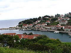
Hovederhverv på øen er dyrkning af vin, oliven og frugt samt fiskeri og turisme.[4][3] Flere landsbyer ligger inde i landet (Grohote, Gornje Selo, Srednje Selo, Donje Selo), mens den største landsby Maslinica og Stomorska ligger ved kysten.[4]. Maslinica er kun udsat for nordvestlig vind, og derfor en god havn for mindre både.[3]
Galleri
 Havnen i landsbyen Stomorska
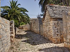 Grohote
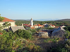 Gornje Selo
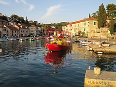 Maslinica
 Nečujam
 Bunja Nečujam
Referencer
- ^ Šolta på peljar.cvs.hr hentet 15. december 2023
- ^ a b Census of Population, Households and Dwellings 2021 (p 82) First Results by Settlements ISSN 1333-1876
- ^ a b c "Šolta på Kroatien-online.com". Arkiveret fra originalen den 20. august 2006. Hentet 17. december 2023.
{{cite web}}: CS1-vedligeholdelse: BOT: original-url status ukendt (link) - ^ a b c General Encyclopedia of Yugoslavian Lexicographic Institute, bind 8 (Zagreb, 1982)
Eksterne henvisninger
Kroatiske øer | ||
|---|---|---|
| Istrien |  | |
| Kvarner | ||
| Norddalmatien | ||
| Centraldalmatien |
| |
| Syddalmatien | ||
Medier brugt på denne side
Forfatter/Opretter: NordNordWest, Licens: CC BY-SA 3.0
Location map of Croatia
Det er let at give dette billede en kant

Forfatter/Opretter: Joadl, Licens: CC BY-SA 3.0 at
The bay of Nečujam Šolta / Croatia / Adriatic Sea. In the background the mountains near Split. View towards the northeast.
Forfatter/Opretter: DioklecijanovaPalata, Licens: CC BY-SA 4.0
Uvala Jorja (Jorja Cove), on the Dalmatian Island of Šolta, part of Croatia. The view is from the main approach by land, a steep dirt road.

Forfatter/Opretter: Joadl, Licens: CC BY-SA 3.0 at
Bunja in U Maslinica part of the bay of Nečujam Šolta / Croatia / Adriatic Sea. Bunjas are single-room, without windows, without wood built round stone cottage with a round roof of limestone piled up. The design has Neolithic origin and was used until the modern era as a tool and storage shed. Bunjas were built of limestone.

Forfatter/Opretter: No machine-readable author provided. Andres rus assumed (based on copyright claims)., Licens: CC BY-SA 3.0
City of Stomorska (Croatia). Own photo.

Forfatter/Opretter: Joadl, Licens: CC BY-SA 3.0 at
The Port of Maslinica on the island Šolta / Croatia / Adriatic Sea. Atmosphere at sunset, looking towards the northeast. At the pier is a fishing boat. In the background the north and south shores of the bay. The old date palm is still standing at the end of the bay in 2012.

Forfatter/Opretter: Joadl, Licens: CC BY-SA 3.0 at
Gornje Selo on the island Šolta / Croatia / Adriatic Sea. View to the west.

Forfatter/Opretter: Joadl, Licens: CC BY-SA 3.0 at
Old limestone houses, some still covered with stones in Grohote on the island Šolta / Croatia / Adriatic Sea. In 2019 the stone-covered roof had already collapsed and no longer exists. Date palms stand to the right and left of the paved path. In 2019 they died because they were also victims of the Red Palm Trunk Beetle.