Western Empire-Europe870
Forfatter/Opretter:
J.B. Bury
Kredit:
Atlas To Freeman's Historical Geography
Shortlink:
kilde:
størrelse:
428 x 317 Pixel (85075 Bytes)
beskrivelse:
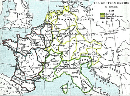
Frank king Charlemagne's kingdom survived the leader and covered much of Western Europe from 795 until 843 when a treaty split it amongst his grandsons: Central Franks ruled by w:Lothar I (green), East Franks ruled by w:Louis the German (yellow), and w:Charles the Bald led West Franks (purple). This particular map is from the Atlas to Freeman's Historical Geography, edited by J.B. Bury, Longmans Green and Co. Third Edition 1903. It is in the public domain and you may download it or print it for any use.
Licens:
Public domain
Yderligere oplysninger om licens til billedet kan findes her. Sidste ændring: Thu, 11 Apr 2024 07:23:54 GMT