WW2-Holocaust-Ukraine big legend
Forfatter/Opretter:
Shortlink:
kilde:
størrelse:
700 x 342 Pixel (242317 Bytes)
beskrivelse:
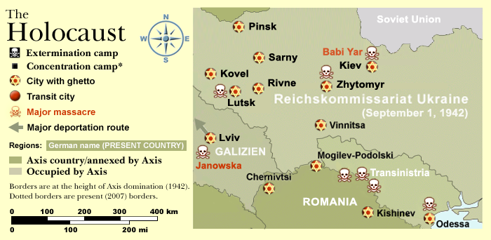
Map of the Holocaust in Ukraine during World War II, 1939-1945.
This map shows all extermination camps (or death camps), most major concentration camps, labor camps, prison camps, ghettos, major deportation routes and major massacre sites.
Notes:
1. Extermination camps were dedicated death camps, but all camps and ghettos took a toll of many, many lives.
2. Concentration camps include labor camps, prison camps & transit camps.
3. Not all camps & ghettos are shown.
4. Borders are at the height of Axis domination (1942).
5. Some regions have German designations (e.g. "Ostland"), with the present country name denoted in uppercase letters in parenthesis below the German designation (e.g. "(AUSTRIA)").
6. Present (2007) borders are dotted.
Map of the Holocaust in Europe during World War II, 1939-1945.
This map shows all extermination camps (or death camps), most major concentration camps, labor camps, prison camps, ghettos, major deportation routes and major massacre sites.
Notes:
1. Extermination camps were dedicated death camps, but all camps and ghettos took a toll of many, many lives.
2. Concentration camps include labor camps, prison camps & transit camps.
3. Not all camps & ghettos are shown.
4. Borders are at the height of Axis domination (1942).
5. Some regions have German designations (e.g. "Ostland"), with the present country name denoted in uppercase letters in parenthesis below the German designation (e.g. "(AUSTRIA)").
6. Present (2007) borders are dotted.
Map of the Holocaust in Europe during World War II, 1939-1945.
This map shows all extermination camps (or death camps), most major concentration camps, labor camps, prison camps, ghettos, major deportation routes and major massacre sites.
Notes:
1. Extermination camps were dedicated death camps, but all camps and ghettos took a toll of many, many lives.
2. Concentration camps include labor camps, prison camps & transit camps.
3. Not all camps & ghettos are shown.
4. Borders are at the height of Axis domination (1942).
5. Some regions have German designations (e.g. "Ostland"), with the present country name denoted in uppercase letters in parenthesis below the German designation (e.g. "(AUSTRIA)").
6. Present (2007) borders are dotted.
Licens:
Kommentar på licensen:
CC, see below. The map is completely unrestricted for any Wikipedia/Wikimedia project.
Licensbetingelser:
Creative Commons Attribution 3.0
Yderligere oplysninger om licens til billedet kan findes her. Sidste ændring: Wed, 31 May 2023 01:07:11 GMT