Treasure-island-map
Forfatter/Opretter:
Kredit:
- Original source: Beidecke Library
- Transferred from cs.wikipedia to Commons by Sevela.p using CommonsHelper.
Shortlink:
kilde:
størrelse:
2369 x 4211 Pixel (2326300 Bytes)
beskrivelse:
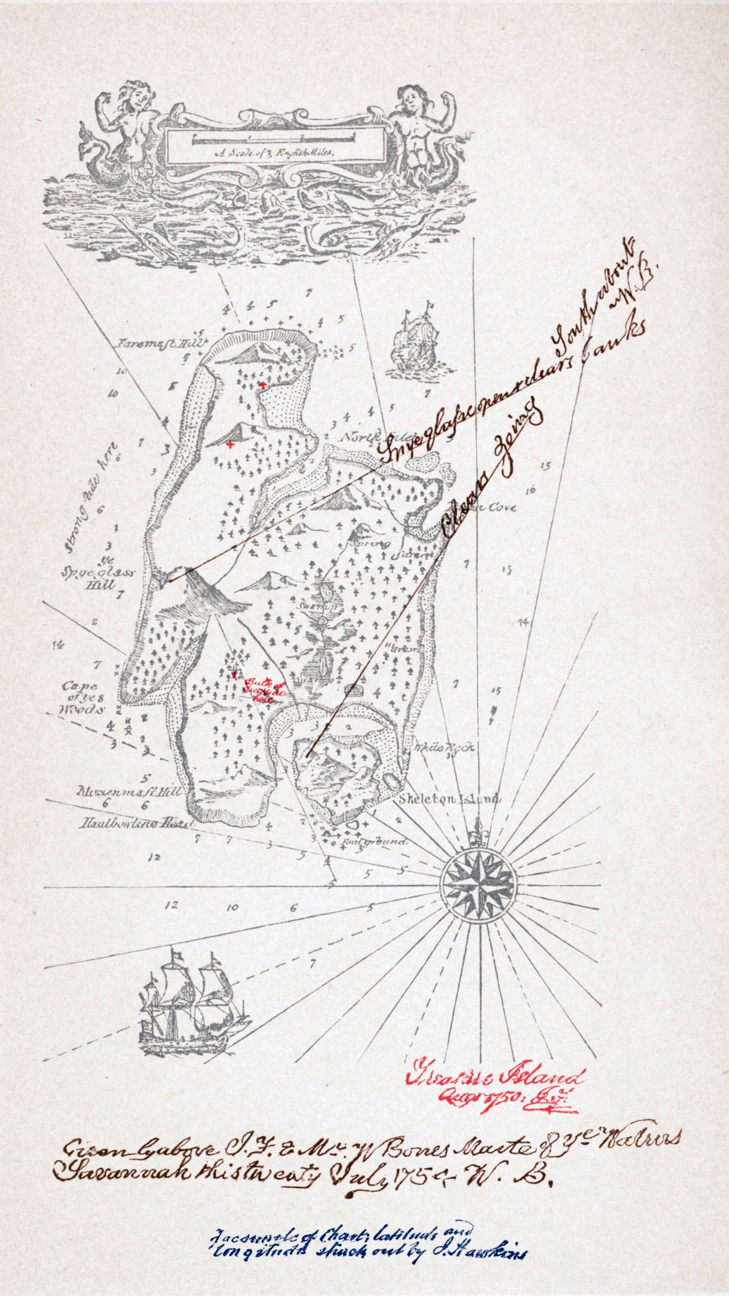
Map of Treasure Island from the 1883 edition by Cassel.
"I sent in my manuscript, and the map along with it, to Messrs. Cassell. The proofs came, they were corrected, but I heard nothing of the map. I wrote and asked; was told it had never been received, and sat aghast. It is one thing to draw a map at random, set a scale in one corner of it at a venture, and write up a story to the measurements. It is quite another to have to examine a whole book, make an inventory of all the allusions contained in it, and with a pair of compasses, painfully design a map to suit the data. I did it; and the map was drawn again in my father’s office, with embellishments of blowing whales and sailing ships, and my father himself brought into service a knack he had of various writing, and elaborately FORGED the signature of Captain Flint, and the sailing directions of Billy Bones. But somehow it was never Treasure Island to me." (Robert Louis Stevenson, My First Book: ‘Treasure Island’, First published in the Idler, August 1894 .
"I sent in my manuscript, and the map along with it, to Messrs. Cassell. The proofs came, they were corrected, but I heard nothing of the map. I wrote and asked; was told it had never been received, and sat aghast. It is one thing to draw a map at random, set a scale in one corner of it at a venture, and write up a story to the measurements. It is quite another to have to examine a whole book, make an inventory of all the allusions contained in it, and with a pair of compasses, painfully design a map to suit the data. I did it; and the map was drawn again in my father’s office, with embellishments of blowing whales and sailing ships, and my father himself brought into service a knack he had of various writing, and elaborately FORGED the signature of Captain Flint, and the sailing directions of Billy Bones. But somehow it was never Treasure Island to me." (Robert Louis Stevenson, My First Book: ‘Treasure Island’, First published in the Idler, August 1894 .
Licens:
Public domain
Kommentar på licensen:
|
Værket er også offentlig ejendom i lande og områder, hvor ophavsrettens længde er ophavsmandens levetid plus 100 år eller derunder. Dette værk er offentlig ejendom i Amerikas Forenede Stater (USA) fordi det blev udgivet (eller registreret hos U.S. Copyright Office) før 1 januar 1929. | |
| Denne fil er blevet identificeret som værende fri for kendte restriktioner under lov om ophavsret, herunder alle relaterede og tilstødende rettigheder. | |
Yderligere oplysninger om licens til billedet kan findes her. Sidste ændring: Sun, 24 Mar 2024 19:12:35 GMT